
Sunday 23rd November. A few weeks ago Trevor Boardman from the Greenheart Project contacted our Society asking about our knowledge of the Leyland Mill Iron Works (Haigh Foundry) and in particular the canal and railway that linked it to the coalfields around Whelley. I had heard of their existence but had no idea where they ran or if there was still evidence on the ground. His offer to show us the routes of these early transport links therefore, was an opportunity we couldn’t miss. So at quite short notice a field trip was quickly arranged.
The few of us who could make it met with Trevor at the Plantation Gates in Whelley. This is just south of the where the Whelley Loop line used to cross the main road to Aspull. Dismantled and made into a public footpath, this line originally opened in the late 19th century creating a by-pass from the L & Y line to the Northwest main line. Our tour started here as the construction of the line has destroyed any evidence of the canal and railway anywhere east of this point.
We weren’t long into our walk when Trevor showed us the first evidence of the canal – a ditch halfway up the side of the embankment. I must admit it wasn’t convincing but as we progressed further down the path and crossed the tarmac road leading to the hall, we found ourselves on a level metalled track. This did look like the embankment of a railway but the ditch running along side did not look particularly canal-like (it could have been just a depression caused by the embankment). However as we progressed along the track, a bank started to develop separating the railway from the ditch. The ditch was also getting wider and thus more convincing as a canal.
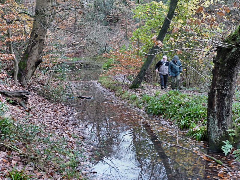
Rounding the next bend the canal feature seemed to take a shortcut through a cutting, the rail track however taking a wider sweep. Further on the track began to separate from the canal and started to go downwards on a gentle slope. The canal however remained level. After a short while the canal ditch ended up in a small body of water which was held back by a dam with a foot bridge over it. This was obviously the source of the water for the canal. 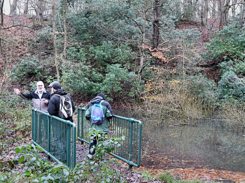 On the other side of the water the canal continued and any doubt that it was a canal was removed as it was now full of water.
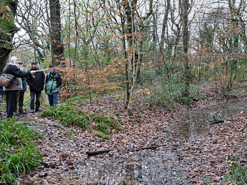
 After passing a disused stone quarry, we eventually we arrived at our destination i.e. Leyland Mill which is now occupied by industrial units. Here the canal stops abruptly as a steep precipice overlooking the mill site prevents it progressing any further. Material would have to be unloaded from the barges here and lowered down to the factory site. In the distance we could see the bridge carrying Leyland Mill lane and beyond more factories some dating to the 19th century.
 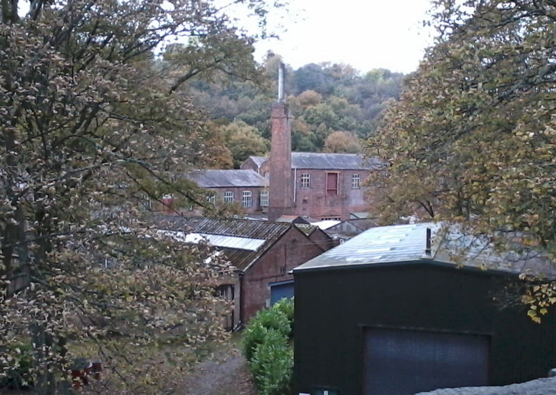 The major mill buildings from the days of the foundry no longer exist but there other buildings and workshops that have survived.
Lord Lindsay, the Earl of Balcarres, established his Iron Works here in 1788 running two blast furnaces and a cupula furnace for re-melting the scrap iron. There were also forges here and also at Brock Mill just a few hundred metres up stream. The theory is that the canal was built to supply the foundry with the quantities of coal required for the smelting and forging. At some point in time the railway line was added to replaced the canal as it was able to run into the works thus avoiding the steep precipice. Smelting ended on the site sometime before 1815 but the engineering works continued until the mid 19th century. It would become well know for producing steam engines and other machinery including the famous Laxey Wheel on the Isle of Man.
The canal and railway are fascinating rare fragments Wigan’s early industrial heritage predating the huge Kirkless Iron Works site by over 70 years. In deed when Haigh Hall was rebuilt in the mid 19th century the estate was landscaped and planted with the ubiquitous rhododendrons – thus sweeping away much of the eyesores left by the many years of intensive coal mining. Studying the 1849 6 inch OS map shows that, apart from the small body of water, there is no sign of the canal or the railway. We are very lucky therefore that evidence for them still survives.
A good project for the Society would be to survey the route properly producing an accurate map (a surveyed was carried out by Donald Anderson when the features were first identified. However this was a height survey to establish that the canal was in deed level and the inclination for the railway wasn’t to great. If we could get permission to dig we could also answer other questions such as how wide the canal was and whether it actually did predate the railway. It would be useful to confirm the date of the canal (mining has been carried out on this estate since at least the 16th century) but proving its age might prove quite difficult.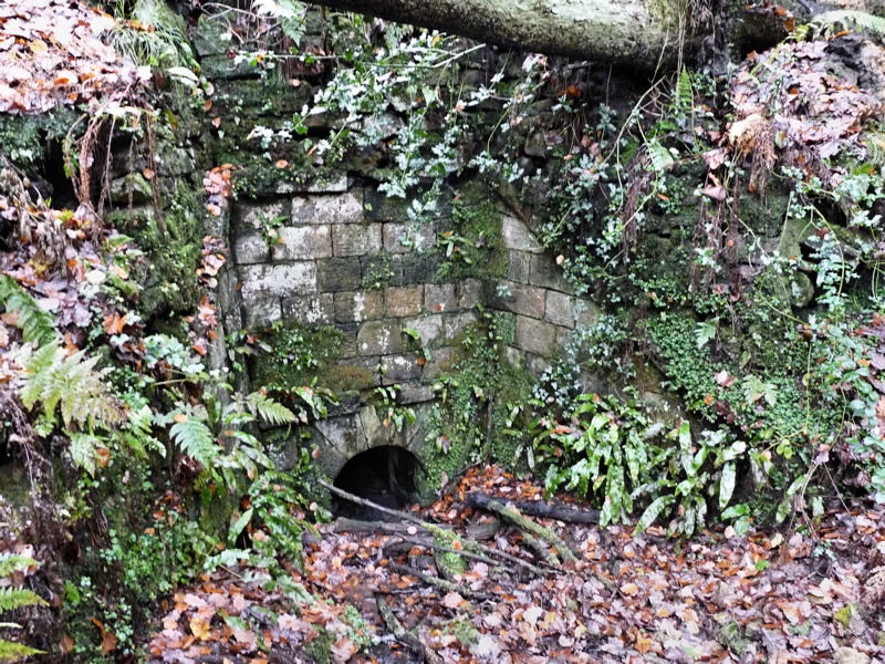 Culvert running under the substantial railway embankment
Soon after posting this I received a link from Eric Walter to the Cloggs & Ganzey Newsletter number 7 (2001) which has an article about a similar walk carried out by the members of the Leeds & Liverpool Sanal Society – http://www.mikeclarke.myzen.co.uk/C&G/C&G7.pdf .
Interestingly the editor has added his own research which suggests the canal was commissioned in 1795 as follows:-
‘The best source of information which I have found is ‘Geographical Change and industrial Revolution’ by John Langton. Published in 1979 (ISBN 0 521 22490 X), this is a history of coal mining in South West Lancashire from 1590 to 1799, and it suggests that the coal mines and ironworks mentioned in this article were part of the Chadwick family’s empire, a footnote to page 178 stating: ‘The colliery was linked to the ironworks by a short canal. Haigh MSS/Canals Box/Articles of Agreement, Lewis v. Haliburton, June 22, 1795.’ When researching the L&LC, I looked at this agreement which was: …between John Lewis of Pool in Montgomery, canal cutter, and Alexander Haliburton for Earl Balcarres on June 22, 1795, to build a navigable canal from the steam
engine at the iron works at Haigh thro’ Haigh Park to Marsdens Farm where Robert Marsden lives and a pit has been sunk for an intended steam engine. Length of canal 860 yards, depth of water 5 feet, width
of canal at bottom 6 feet, slopes 3 horizontal to 2 vertical, width of water surface 21 feet. Embankments and towing paths 10 feet wide at the top (1 foot above water level). Puddling where required to be 6 – 8 inches above water level. Cost £315.’
(As yet I haven’t be able to locate Marsdens Farm.)
I have walked this before never thought it was a canal think I may walk along it again. I look foward to a update.
Hi
thanks for this article following a suggestion that i visit your website by one of your members at kirkless sitr last sun . I read the article and went to the site which i have walked many time but never new it was a rail link and canal. I am now taking friends to see it.
i believe marsdens still farm in the area
cheers
colin h
Hi again
there is also what appears to be the remnents of a shaft and the head gear supports in the old quarry which is adjacent to the path of where canal would have been prior to it being landscaped.
cheers
colin h
Hi Colin,
Glad you like the article, not sure there was ever a shaft there – there was a wooden head gear but it was only installed for display.
Bill
Hi bill
yes it did look a bit perfect.
cheers
colin h
Hi Colin,
Found this about the pit head gear https://www.flickr.com/photos/28709338@N04/14605941425
– the gear was put there in 1980 having been re-erected form Bispham Hall Gauntley Pit, Billinge (last wooded head gear in Lancashire).
Thanks for that
Hi Bill,
Im waiting for the weather to dry so i can take a friend along the canal. It is a bit slippy further along.
Cheers Colin H
Interested to read about the walk along the old canal down to Haigh Foundry. I’ve been interested in the local industry for years and have collected quite a lot of info on the Foundry and some of the remarkable machines and ironwork they made.
My other connection is that I was in charge of moving the headgear from Bispham Hall to Haigh in 1979-80. To be honest, it was a daft place to put it as it was never really looked after, but at least Wigan MBC did offer it a home.
I think the other notable survivors from the Foundry era are the two cast iron bridges over the Douglas, one at Brock Mill and one behind the surviving foundry buildings.
Regards
Ted McAvoy
Hi Ted – nice to hear from you. A shame about the headgear – it was never going to easy to protect it there but as you say at least they tried.
The Haigh Foundry is a fascinating site – the more I read about it, the more impressed I am about what they were able to make there.
As it happens our Society trip has just had a trip to Bersham near Wrexham which, as you may know, was operating about the same time, – so we’ve been learning quite a lot about the iron making industry recently. Although iron smelting doesn’t seem to have been too successful at Haigh, their cast iron production was immense. There must have been a number of ‘air-furnaces’ on the site (wonder if there is anything left of them). I’m particularly impressed by the number of steam engines they made (apparently over 100 – including two for Brunel’s GWR).
I have seen the bridge at Brock Mill but not the one near the foundry buildings (a site visit seems in order in the near future).
I have just read with interest the article on `Haigh Canal and Railway`, I was born and brought up in the Haigh Foundry Cottages, during the 1940`s and 50`s. and have always been interested in the history of the foundry. I have collected quite a lot of material including quite detailed maps of the two rail links to the foundry, If you let me have an e-mail address I will let you have copies. With regard to the canal I think its real purpose was to supply water to water wheels at the foundry. There are a number of ponds in the upper plantations, beyond the railway line. that all drain through ditches into the pond at the end of the canal thus providing a steady supply of water.
Hi Bill, great to hear from you. Yes, any information about the foundry would be very welcome – I will send you my E-mail address shortly. I must admit it hadn’t occurred to me that the ‘canal’ could be just for supplying water, however it does make sense (although there should be signs of a sluice or something at the foundry end – something to look for next we’re out there).
Hi Bill
I am very familiar with the layout of the plantations and the ponds you mentioned. Ive visited the canal many times and find it facinating that i have walked the paths and never realised its purpose untill reading these pages. If possible could i have a copy of the maps please.
Cheers
Colin Holland
Hi Colin,
Neither the canal nor railway appear on any map we’ve seen – the canal went out of use well before the 1849 OS map was published and the railway, which came after the 1849 map, was gone before the next survey late in the 19th century. We do however have a LiDAR image which picks out the route nicely. I published it in a Newsletter earlier in the year :-http://www.wiganarchsoc.co.uk/content/News_Letters/news190.htm
Hope this helps,
Bill
Hello both Bills (Melling and Aldridge),
What an interesting and enlightening article. Would it be possible to share Bills detailed maps of the two rail links down at the Foundry?
I currently have one of the smaller industrial units down at what remains of the Foundry and am enjoying founding out the history.
Regards
Carl Middleton
Hi Carl,
What Bill sent me was an extract from the Mining and Geology Trail to Haigh Plantations Wigan – Booklet No.4. It was published by Wigan Metro Leisure Dept and gives details of the evidence for the first railway which existed between 1856 to 1869. Bill also sent me a copy of the 1907 map which shows only the second railway which took over from the first in 1869 and lasted till 1909. I’ll send these to you when I get chance.
Best regards
Bill Aldridge
Hi Bill.
I’ve got both of the documents that you are referring to so there is no need to send them over, thanks anyway for letting me know what those actual references where.
I was down at the Wigan reference library today looking for a reference made to this railway line (contained in “The Industrial Railways of the Wigan Coalfield – Part 2, Townley, Smith and Peden).
The news was contained in the Wigan Examiner dated 8th of March 1862:
“….the means of shipping(*) where provided by the construction of a railway of ample strength and dimensions which skirts the plantations and, pursuing the track of the old canal passes through the yard by Haigh Foundry” *Presumably this meant coal from the Lindsay Pit going down to Haigh Foundry for use/land-sale and finished goods from the foundry coming back via the Lindsay Pit and onwards to the mainline connection at New Springs (thus avoiding the steep climb up Leyland MIll Lane).
There was a rather interesting end to this news article:
“At the foot of the main road leading to the Hall and not far from the path to Bottling Wood, Mr Pearce erected a small but handsome lodge, thus making his railway ornamental rather than otherwise”
I wonder if anyone can shed any light on this?
Great piece of research Carl, sort of confirms that the ditch was in deed a canal. Not sure where Mr Pearce’s lodge would have been (could be Whelley Lodge I suppose). Nothing else is shown on the 1893 OS map but could have been destroyed when the Whelley Loop Line was put in.
In the early 1970s I was at Wigan Art School doing a predip for 1 year before doing a 3 year diploma at Exeter. I have a number of black and white photos taken along the canal (towards Rivington) and also of Lever Park, Rivington plus a few of Wigan itself. Most of them are filed as negatives and contact strips and I wondered if copies they might be of interest to your group. I also noticed that Haigh Windmill was restored in 2011 and I am sure I have a couple of photos of that as a ruin from the same period.
Hi, Peter,
These photos sound fascinating – I’ll contact you directly so we can arrange something.
Bill Aldridge
Hi, just thought I would help with the location of Marsden Family farm, the main farm was located on wigan Road, next to the colliers Arms, at the foot of ivy mount, around 200 yards from the bridge over the Leeds to Liverpool at new springs.
The farm yard and building have been sold, but the last of the Marsden family is Mandy who runs a stables business. As you cross the bridge headed towards Aspull from wigan, immediately after the bridge there is a turning, this leads to where Mandy lives in the valley behind the original farm location.
The mineral railway line which crosses the Leeds to Liverpool at the old dairy pit site, has several branches here, as well as a lot of evidence of the mine buildings.
I’ve done some digging into the local industrial heritage around here as I grew up in Aspull, when I was young there was a lot more in the local area,but alas much has been lost.
I walk the areas around the loop line regular as it is near home, I did wonder a out the bodies of water you come along on the route towards Leyland Mill, great information so I can pick out the features for myself.
Hi Andrew, this is great information. You mention that this was the main farm, I suspect therefore that they had another farm further down as this location is far to high for a canal to have reached it from the Lower Haigh Plantation. We’re assuming the farm would have been somewhere near to where the Lindsay Pit was located. The later railway running from the Leylands Mills probably connected to the mineral line you mention giving it a connection with the main line through the the Springs Branch line.
I have done a quick recce of industry near the Leeds Liverpool from Top Lock to Ellerbeck. I am finding difficulty in getting info on most that disappeared pre 1920s. There are several areas near Haigh and between Red Rock and Adlington which have obviously seen industrial activity. Is there any society that I might join who have similar curiosity?
Hi Simon, quite a few years a go we researched a water mill on the Douglas at Arley (http://www.wiganarchsoc.co.uk/content/Projects/Arley_Mills.htm) and therefore was interested in the industrial activity in the general area (although not in great detail). We have some early maps if they are of interest – was anything specific you were looking at?
Hi too all local enthusiasts
Can anybody help me with any information regarding the ponds within Haigh hall plantations.As a Angler,I have a passion fishing old pre/post industrial revolution waters.Over the last few years I have learned and collected information in the origins of these waters,from marl pits to old pit lodges.I have had the privilege to have fished waters that date back 200 plus years.During these visits I try to find any useful information that has a link too the waters,in which during time i log the information along with depths features history and obviously it’s fishing qualities.After a little research into the ponds in the plantations I was led to believe I was fishing a pond that was within the grounds of the old Dairy pit.Like most collieries,a reservoir of some sort was mandatory and I was wondering is this pond a actual man built lodge or was the pond part of the workings itself.Am hoping to refresh the minds of locals who knew these ponds.information such as local names of ponds,origins or old fishing stories would be extremely appreciated.I thank you all for taking out the time to read my post.bet wishes
Hi Gaz, I think everyone interested in the origin of ponds in NW England will find this article of considerable use (free download)
https://www.researchgate.net/publication/309772785_The_Distribution_and_Conservation_of_the_Ponds_of_North-west_England
As for the ponds in Haigh Lower Plantations, it seems likely – not certain – that one of their functions was to serve as feeders into the special contour canal to Haigh Foundry, as they seem to have been the only source of topping up water.
As for the railway line in the Haigh Lower Plantations, when we wrote the Mining and Geology Trail for Wigan Council, I requested the local metal detecting club to walk along the railway route and they found several metal holders for the rails, but not the rails.
As for the function of the canal, we found strong evidence for an adit opening directly to the canal, indeed no other way to get out of the adit. This was if I recall correctly The Ince 4ft seam of good coal resting on a nice fireclay. Down by the Douglas we excavated the very high quality fireclay of the Ince 7ft seam, that seems to be the source of clay for the making near-porcelain by the Fulham Potter.
We also found another adit into the Ince 4ft which we managed to correlate with an illegal mine worked in Victorian times by unemployed skilled miners during one of the miners strikes. The entire Wigan police force of constables was ordered to evict them but the miners refused to come out. There was a standoff, and – as the local paper explained – the entire Wigan Police Force fell asleep and the miners made their escape!
Hi Robin, great information. You mention the very high quality fireclay that the Fulham Potter used for his near-porcelain pots. This was John Dwight who lived in Wigan at the time. In their Wigan Coal and Iron book Donald Anderson & A.A. France say he was experimenting with clay from or near the cannel pits – ‘in April 1672 he obtained from Charles II a patent with the sole right to manufacture porcelain or China, Persian ware and Cologne ware, which, in the form of drinking vessels and bottles’. A year later he ‘moved to Fulham where he established the celebrated pottery which was to remain in business for 300 years’. It would be interesting to know where you found the clay and whether this was the mug clay they mention (and where the Mugg House was located which could well have been near by).
Hi from Manchester, I have lived abroad in Mongolia, Kyrgystan, Kazakhstan and Afghanistan since 1995 so somewhat out of touch. When we opened the Haigh Mining and Geology Trail in 1979, more than 150 people turned up and it was a bit of a challenge for our string of guides to explain the features. A few points:
1: the bridge over the Whelley Loop Line – this is much wider that necessary, in order that steam trains – burning the otherwise unsaleable poor coal – would not WUMP His lordship and companions who might be crossing the bridge. Old records show the air pollution and sparks ruined farmers crops and compensation had to be paid.
2: Closure of the Whelley Loop Line -. it remained inactive but not officially closed. It order for it to be declared Derelict and therefore 100% Derelict Land Grant could be obtained, British Rail first had to declare it as non-operational land. As was Lib Dem Councillor at the time, so I took the initiative to call BR Euston from the Telephone Box by Standish Bleachworks. I spent a fortune talking to them, but finally they AGREED and BR penned me a short letter confirming the route was permanently closed and therefore non-operational. I took the letter to Wigan Council and the Derelict Land Grant arrived. So far as I am aware, this was the one and only railway line closed by a bloke ringing up BR from a Telephone Box. I felt proud at what I had done, but in recent years given ear-ache by engineers telling me I had destroyed the best route for the HS2! Can’t please everybody… cheers! Robin Grayson FGS
Cheers for this Robin, it’s great information (sorry for the late reply, not been keeping my eye on recent posts).
Hello All, In the 1970s I worked at the then Potter’s Herbal Supplies which adjoined the Malt Works at Leyland Mills which at one time belonged to Haigh foundry, these building were situated by going along the road under the bridge that carried Leyland Mill Lane above. The last time I was down there in Valley Gate the road under the bridge was gated along with being barricaded, also not long ago the buildings had been set on fire, and I’m sure that I’ve read they was to be cleared for housing.
Along the front of these buildings were old railway lines and the remains (girders) of an old bridge across the River Douglas, apparently this railway supplied coal and other materials to the foundry at Brock Mill and Haigh foundry which is now a gym or fitness centre, this did have a tall chimney at the front which was removed some years ago. Molly Ashcroft who was a cleaner in the offices said that as a young girl folks could get a train from which I’m sure she called Haigh station which was situated down there, the railway then ran through the plantations before joining the Whelley loop line. At one time you could walk along a path close to where it ran which you got to through Valley Gate and went behind the stone cottages above the river bank, though this was at some time blocked off either by the owners of Valley Gate or the cottagers.
There was also another cottage close to this line and bridge at Leyland Mills, whether it was at one time something to do with the railway I don’t know, this was where the boiler stoker lived and was demolished in the early 1970s to make way for a warehouse to be built.
If the site has now been cleared I doubt any evidence of the railway lines around there shall now remain or have been retained. Best regards, Cyril.
Apologies if I’ve repeated any information about this line that you may have got from Bill Melling.
Cheers Cyril, very useful information (sorry for the late reply, not been keeping up with recent posts)