
(this report was first published in the Society’s annual Journal of 1989 – it has been re-edited for this blog)
For the two previous years the farmer at Brimelow had tried to grow a cereal crop in his north field, but the results had been poor. This year he reverted back to hay which he harvested towards the end of June. This gave us the ideal opportunity to carry out a small weekend excavation (the first ever to be carried out by the Society) to try to discover the existence of the Roman road which we believe runs across this field.
LOCATION
The society first became interested in this. particular field in the early 1980’s (producing a Report in 1983). At that time it was possible to see, during the winter months, a green line stretching across the field from north to south. Our attempts to capture this effect on film had proved difficult. However. in 1985 using a soil resistivity metre borrowed Greater Manchester University extra-mural department, we were able to carry out a large area survey. This produced convincing results, (see Brimelow Farm 1985), indicating a possible road like feature towards the centre of the field. Significantly this was in the area where we had seen the green line.
EXCAVATION
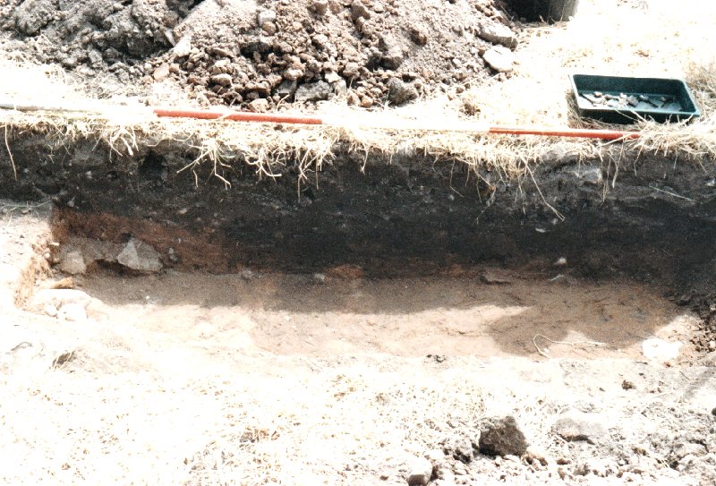
Using this information we marked out our first trench (Trench 1) – 1 x 3 metre long, 25 metres south of the allotments and 80 metres east of the cottage wall (Ref Map Fig 1). This in theory would straddle the anomaly.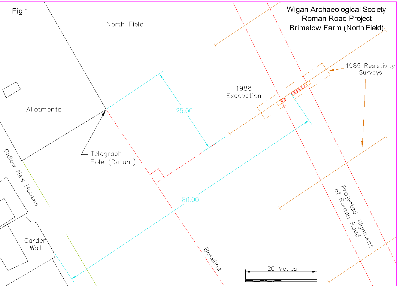 As soon as we removed the topsoil large stones of all shapes and sizes began to be exposed. It was obvious the feature lay just a spade depth below the surface and therefore had been greatly disturbed by the plough. We had suspected this would he the case from the reports the farmer had given of how difficult it had been to plough this particular section, often having to lift the blades clear of the soil to avoid damage. Despite this, a considerable amount of the feature remained, covering the whole area of the trench.

Trench 1 looking west
No actual road surface had survived but the large stone blocks set in clay were clearly part of a substantial structure. Our main task was to try to discover the features’s width (assuming it was the road running north south). Therefore a second trench (Trench. 2) was started of similar proportions 8 metres west of the first. Unlike Trench 1, no stones were encountered to a depth of over 25 cm (10 inches). It was decided therefore to concentrate the effort on the east side of the trench. At about 30 cm light brown clay layer began to emerge which we presumed to be the natural sub-soil. We therefore extended this trench 1 meter in an easterly direction towards Trench 1. With still no feature exposed. a new trench ( Trench 3) was started 1 metre further east between Trenches I and 2. thus placing its easterly edge only 2 metres from Trench 1. This time the stones immediately appeared. As sods law dictates. we had skipped over the crucial edge area which had to lay somewhere in the section between Trenches 2 and 3. When the two trenches were joined and the surface cleaned up, the edge of our feature was clearly revealed. It was in the form of quite a pronounced change in colour from the light sandy clay of the stony section to the dark soil fill of a shallow depression. Then a gradual change lighter to the colour of the subsoil. To examine this section more closely a deeper cut was taken and the side wall cleaned ready for drawing and photography.
Trench 2&3 looking south (showing road edge and shallow ditch)
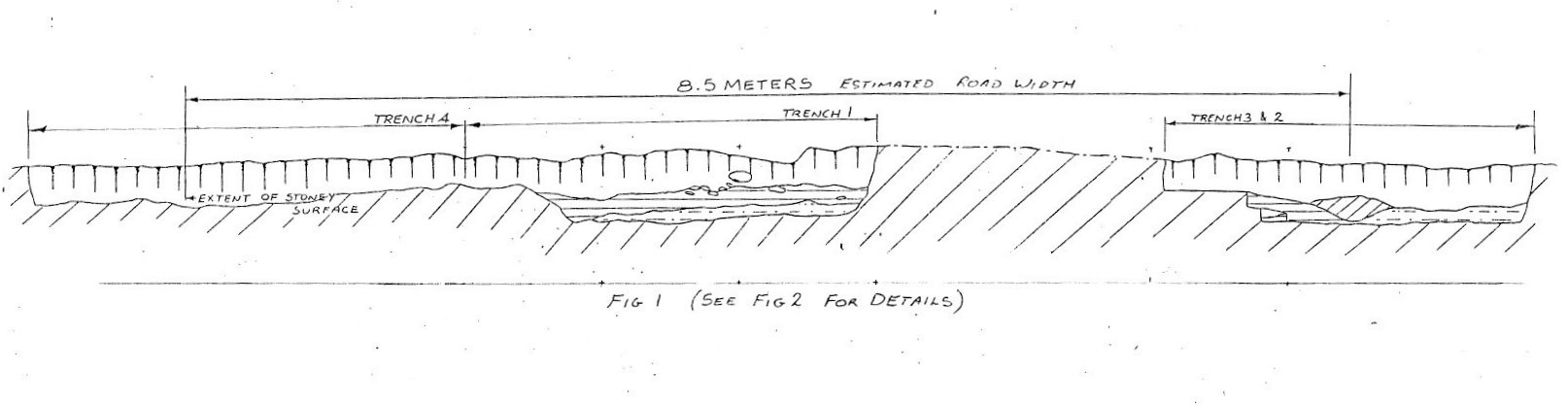
The next task was to find the edge on the other side of the road and therefore determine its width. On the following day a 1 x 1 m trench (Trench 4) was started 1 metre to the east of Trench 1. The stony surface was again encountered although this time not so pronounced. As we extended the trench eastwards there was a gradual reduction in the amount of stones until the surface was free of them altogether. Joining Trench 4 to Trench 1 completed the extent of the excavations.

Trench 4 looking west
However no specific edge had been revealed at this stage and, as time was rapidly running short, we had to make the decision to stop any further digging. We had uncovered about as much as we could effectively record. This meant that we were not able to determine exactly the width of the road. However by estimating the extent of the stony surface, a width of about 8.5 metres (27 ft) was assumed.
 When the stony surface of Trench 1 had been thoroughly cleaned, it revealed a jumbled variety of stones compacted into light reddish sandy clay. The main type of stone used were granite pebbles of various sizes, some as much as 20 cm across. Also there was a significant quantity of sandstone blocks of similar proportions scattered randomly in the fill. Many of the stones showed signs of being broken from much larger blocks. In some areas it was obvious the smaller stone pebbles had been rammed into the clay between the larger blocks to form a solid foundation for the road surface which would have been typically of rammed gravel. This type of construction was discovered some years ago when a stretch of the same road was excavated by the Chorlev Archaeological Society at Hic Bib Lane, off Coppull Moor Lane between Coppull and Standish.
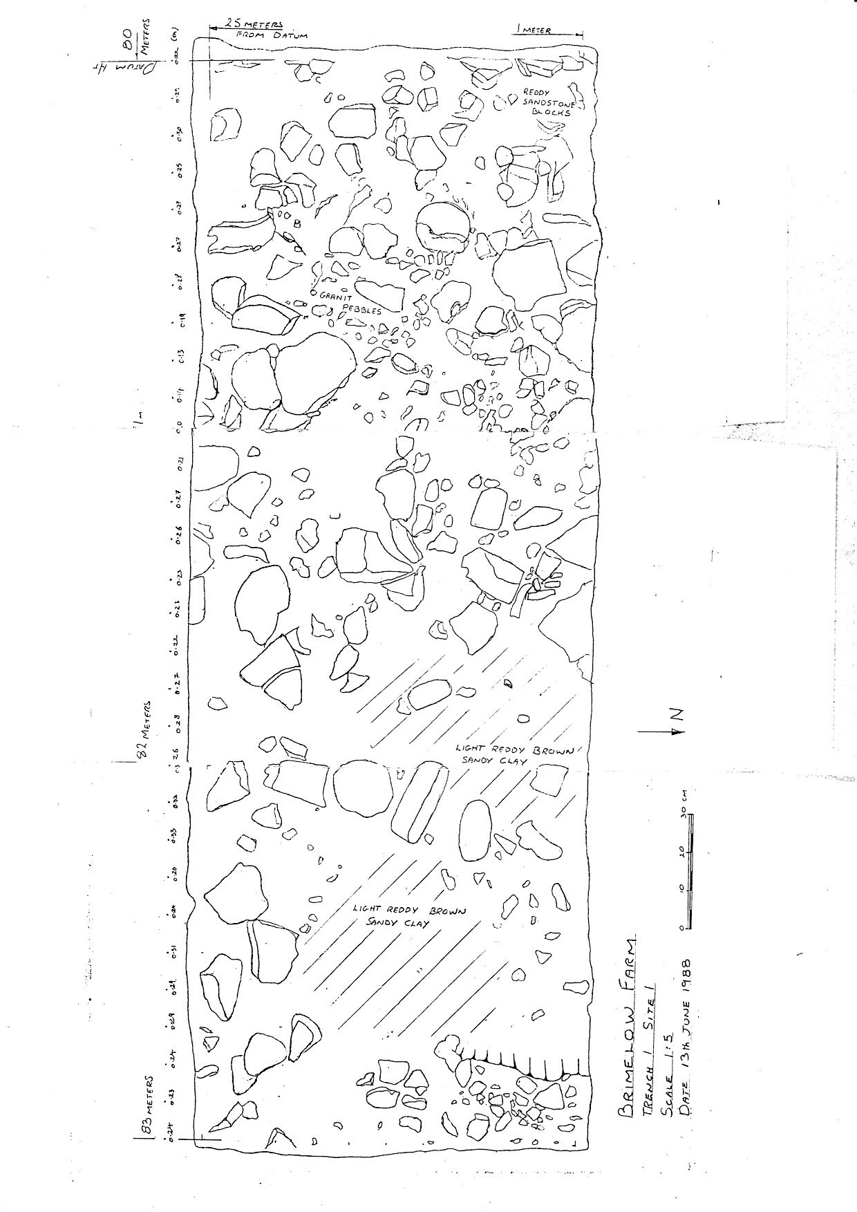 All pottery found in the excavations was either Victorian or slightly earlier, the exception being one piece. This, because of its rough lighter fabric was later identified as possibly medieval. Apart from the overall construction, there was no direct evidence of the road we had discovered had a Roman origin.
(Back)