
Tuesday 22nd November
Day 60 – Last day of the season today so just three on site i.e. Bill, Chris and Patrick. Patrick had arranged with Nick the farmer to come with his machine to do some backfilling (which trench to backfill however had yet to be decided). Even with all the heavy rain recently, most of the trenches had remained relatively dry, the bedrock seeming to be very porous (even Trench 7 which had previously filled up, was more or less dry now that more of the bedrock had been exposed). We decided therefore to keep most of the trenches open (with the farmer’s permission) as we perceived they would survive the winter. Trench 4 however had already experienced a collapse on the section wall, it was decided there was no point in keeping it open and this therefore would need to be backfilled.
The question however lay with Trench 6a which constantly filled with water and was almost to the top. We haven’t finished investigating the ditch here as we had only see bedrock on the very bottom. There is a thought that the bedrock may be hiding behind side walls and we needed more time to investigate this. If we backfilled the trench, it would be a huge job to re-excavate. If we left it open, the section may collapse into the water creating a porridge that would be even more difficult to remove. The section looked quite stable though despite the water and the thought was that if it did collapse no archaeology would be destroyed. It was decided therefore that if we could we would leave it open.
While waiting for Nick to arrive, Bill set about draining Trench 6a just to get a better idea of any potential damage (our pump working well at the moment). Apart from the expected slutch in the bottom, most of this feature seemed to have survived its period under water.
 When Nick arrived it didn’t take him very long to backfill Trench 4 and he was happy with the plans for the rest of the trenches. It was sad to see the ditch disappear but it was well recorded and and the trenches would need to be backfilled eventually.
Saturday 19th November
Day 59 – After a two week break due to the bad weather, we were back to day, not to do much work but to show independent archaeologist, John Trippier around the site (his knowledge of the prehistoric would be invaluable). Showing him around today were Bill, Patrick and Chris (Peter Cooke was also there for a last look before we close the site down for the winter). John was surprised at its size, width and depth of the ditch and the strange junction of the ditch sections. He tried to draw some comparisons with the causewayed ring ditch at Bleasdale (John has a deep knowledge of this Bronze Age site having given us a talk on it at last month’s Society meeting).
After John had gone Patrick helped Bill to do height survey (using the dumpy) along the Profile 3 which runs north-south across the site. Bill thought this would be an interesting profile as it ran along the field contour, thus showing a clearer view of the mound (the other profiles he’d done included the slope of the hill therefore the extent of the mound was more ambiguous). When drawn up the result clearly showed the mound extended almost up the the ditch allowing for little or any berm. From our excavations in Trench 1, 2 and 3 we had experienced a layer of clay towards the centre which seemed to be what the mound is made of. Bill wonder that, because this clay was ‘clean’, it could be a natural deposit, disappointingly this would meaning the mound could be natural rather than manmade. Chris pointed out though that this contradicted the result from our testpit in the centre which had shown a mix of material suggesting in the area it was manmade (could the ancients have utilised a ready made natural feature (this is on of the questions we hope to be able to answer next year).
Thursday 3rd November
Day 58 – Much better day today weather-wise and so a good turn out. With Bill and Andy today were Chris and John Needle with Patrick as usual joining in the afternoon. Bill had brought the pump back from servicing (the problem was a loose spring on the throttle) and immediately set about draining Trench 6a. Even with the pump performing really well, it still took quite a while to empty the large quantity of water in the trench. When completed the amount of slutch and the slippery surface meant that work in this trench was not really practical. Bill asked Andy therefore to dig out more of the backfilled Trench 2 (in the area around the new cut between 6a and 7). This was because Bill was having problems understanding the stratigraphy in Trench 6a. Trench 2 had revealed a layer of bright soft sandy clay between the sub-soil and the hard orangey natural. This layer had got thicker going towards the centre and therefore had been assumes to be part of the central mound itself (although this it not what was found in the test pit recently dug). The section revealed in the north wall of Trench 6a (on the east side of the new cut) also had this bright soft sandy clay but lying under the fill of the ditch. The new cut proved that this fill extended as far as Trench 2 perhaps showing that there was a ramp leading into the terminus. A very clear layer of iron pan (a think layer of rust under a pale grey layer) was delineating the top of the fill where it interfaced with the sub-soil.  The iron pan and ditch fill was also evident on the west side of the new cut. However the bright soft sandy clay was not so clear – in fact seemed to be disappearing under the harder orange clay which is much higher here than the level in the new cut. If this is the case then the bright soft sandy clay must be a natural layer (and therefore not part of the central mound as initially thought). This layering sequence seemed to be confirmed when more of the south section of Trench 2 was revealed.
  Meanwhile Chris and John worked on the ditch wall in Trench 7 but things weren’t going to plan here either. As Chris cleared the soft fill from the southeast wall, a huge crack was becoming apparent. John, troweling the southwest side also revealed a strange streak of bright hard material.
  This streak stretched right across the south side and, when Chris checked it in the section, it was shown to be diving vertically downwards. In fact as Chris worked his way westward, the bedrock was beginning to move inwards into the ditch and showed that the bright hard streak was part of the natural bedrock.
  Time is running out now for work to continue on this site and some backfilling seems inevitable (in fact the wall in Trench 4 has already collapsed). We will also need to cover the burnt wood feature in Trench 5. Patrick will arrange with Nick therefore for a day when we can come and effectively close the site down.
Tuesday 1st November
Day 57 – The weather is becoming unpredictable now so we’re finding that we have to be more flexible. Today’s visit therefore was arranged at short notice. This meant only three attendees, Bill and Chris with Patrick joining in the afternoon. Plenty water in both trenches 6a and 7 (but 5 and 5a were perfectly dry). An attempt was made to drain Trench 7 using the pump but only managed half before packing in (Bill decided he would take it home and give it a service). The trench therefore needed to be finished by bailing out by hand. This revealed the extended bedrock floor uncovered last week. After Chris had cleared the silt and dried the floor, he exposed the bedrock wall Andy had uncovered the week before on the east side. The west side however wasn’t so obvious (Bill speculated whether it didn’t exist there at all, Andy may have cut the clay wall of the ditch, which shows signs in the section).  Chris set about uncovering more of the bedrock of the east wall hoping to chase it around the terminus in an attempt to reveal the true terminus profile (was it beginning to look square – like 5a?).
In the meantime Bill worked in Trench 5a cleaning the SW section wall ready for recording. This ditch had been different than others in that it has layers at its base i.e. a thick layer of clay on top of a layer of compacted gravel. These layers contained large stone cobbles. With the weather closing in it was decided to call an early finish.
Wednesday 26th October
Day 56 – No Bill today but still a good turn out. Joining Chris were Brian, John N, Steve, Bob and Andy. The conditions were very wet and slippery so we were limited to which trenches we could access.
Trench 6a was drained with the hope it would dry out, but even in the afternoon it was too muddy and slippery to enter. Trench 7 was drained and carefully entered. Andy and Brian exposed the rock cut bottom of the ditch to enable them to work on a dry firm surface. They found the eastern rock cut edge and by the end of the day they think that they had the western edge too.
Trench 5 and Trench 5a were fine to work in (once you had got in). Steve, John N and Bob cleaned the rock floor and sides ready for recording with the drone. 
 A couple of breaks for heavy rain showers, and an attempt to cut better steps on both trenches to make them safer to access.
John helped Chris to continue working on the burnt wood feature in Trench 5 and was able to expose more of it. It now seems the feature, which includes the overlying cobble stones, is huge – probably circular, maybe 1.5m diameter and runs under the steps and marker and may have been 0.3m high.
The drone survey produced a clear orthometric overhead image and a detailed digital elevation model which can be used to create profiles of any section. You can see in T5 the circular shape of the feature containing the burnt wood (pale green). Several smaller sections of burnt wood have now been found.
Thursday 20th October
Day 55 – Better turn out today – Joining Bill, Chris and Andy were new recruit Brian and then John Needle and later a reluctant Patrick, not convinced with the weather. It was wet but Chris’s internet said it would be blown over by 2.00 (this didn’t happen – never trust the internet).
First job for Andy was to continued removing the last of the clay from at the bottom of the ditch in Trench 5a. John was asked to worked on the ditch end wall in Trench 5 while Brian was instructed on clean the ditch section in Trench 5a ready for drawing. Chris’s internet proved incorrect and by 3.00 the rain got the better of us – all we got to do in the end was photograph the section (quite complicated as the upper fill was not showing the usual pattern across the ditch). 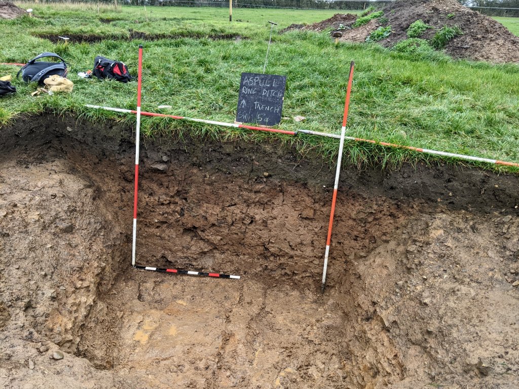 While work continued in Trench 5 and 5a, Bill and Chris set about marking an area on to top of the mound ready to put a test pit in. The intention was to avoid any of the possible features indicated by the resistivity result . A 0.7m x 1m pit was therefore marked out on the the south side of Profile No.1, 0.3m east of the 25m crossing Profile (No.2). When Patrick arrived he approved of the location, and so the test pit was dug there.
  As soon as the turf was removed, a clay surface appeared – it lay just under the plough soil without any sign of a sub-soil. The clay was mottled, black and grey streaks intermingled with patches of light brown but very little stone. This strongly suggests that the mound (which shows up on LiDAR) is not a natural i.e. the variety of coloured clays most likely represent a manmade deposit rather than a natural build up.
The question we were trying to answer was, what exactly is the mound made of. If stone, it would explain where the material from the ditch went. The result showed this not to be the case but that doesn’t necessarily rule out this being material from the ditch. John Smalley’s theory is that sandstone tends to disintegrate over time when exposed to the air and there were some signs of this process in the test pit. This is an attractive theory as it also explains where the fill in the ditch came from. However our test pit mainly consisted of sandy clay.
It was decided to remove another ten centimetres just to confirm that it wasn’t just a thin upper layer. This revealed more of the same including a large area of black material – not charcoal but seemingly the internals of a disintegrate stone, similar to the one found at the bottom of Trench 5a. 
After recording with photos, the test pit was back filled. By 3.00 the rain was getting the better of us and so we called it a day, but happy to have gained more knowledge about our enigmatic feature.
Wednesday 19th October
Day 54 – Varying weather reports resulted in uncertainty about which days to dig on – it resulted in only three of us attending today, i.e. Bill, Andy and Chris.
After the success in finding the bedrock in the terminal end of the ditch in Trench 5, Chris was curious as to why we hadn’t seen any bedrock in the side walls of the ditch in the adjacent Trench 5a. We had bedrock at the bottom but there was still a quest whether this was the bottom whether the clay layer was the natural bottom. Andy was given the task therefore of exploring the outer wall in Trench 5a at the base of the ditch. It wasn’t long before gratifyingly he came across bedrock in the wall. Chris therefore set about looking for bedrock in the inner wall which again began to emerge not far below its surface. By the end of the day they were able to the reveal the bedrock almost all the way around this ditch terminus. It not only proved that this was another terminus but also, very strangely, it was square ended. 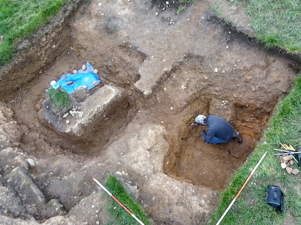 Meanwhile Bill worked on the ditch in Trench 3 as he had realised that the section had not been properly recorded, particularly on the northwest side. He therefore set about trowelling it down and cleaning the section. He soon realised that this, inside edge of the ditch was just as complexed as the outside edge (if not more so). It’s difficult to see but the upper fill of the ditch seems to be different from the subsoil. It finishes when the bedrock is reached but there is signs of a hard compacted layer of clay on top of the bedrock (which changes from small friable pieces to large solid lumps). Moving further inward, when the big lumps end, a layer of soft orange clay appears. This layer is lying on top of the hard compacted layer – it’s very uneven with holes here and there (there is a similar soft orange clay in Trench 1).
Saturday 15th October
Day 53 – Just four today, in fact Bill and Andy could only make lunch time (Bill on child minding duties in the morning). By then Chris and John Needle had spent sometime working on the ditch in Trench 5, John removing more of the baulk covering the end wall and Chris chasing the bedrock on the inside wall. Here a sharp edge seemed to be emerging and Chris wondered if it matched the niche found by Patrick on the outside wall. The complete profile of the ditch’s terminus was now taking shape. Chris attempted some drone work but the dull rainy day wasn’t helping with the photography (neither was Thursday’s bright sunny day for the opposite reason i.e. casting deep shadows across the trenches). Over in Trench 6a, Bill was determined to make progress with the recording, so once again set about draining the ditch. This time he put the pump inside the trench with the hope of reducing the suction pressure needed to lift the water out of the ditch. This seemed to work but the slippery conditions inside the trench made moving the equipment around quite precarious. Despite the difficult conditions, Andy set about cleaning out the bottom of the ditch and trowelling down the south wall, while Bill dug out the baulk that had been left in the middle so that the south wall section could be drawn. The section here is particularly interesting as it shows a thick iron pan layer marking the top of the fill, and also at least two layers of fill below it, first a dark brown layer, then a lighter brown below it (difficult to pick in the photo). Intermittent showers were making their task more difficult but by the end of the day, Bill and Andy were able to record the section (at least what they were able to dig down to – further work required here, preferably on a much dryer day).
Thursday 13th October
Day 52 – On site today with Bill and Chris (back from his hols) were Steve, Andy and John Smalley with Bob and Patrick (also back from his hols) joining later. We also had a new volunteer, Brian Smith who happens to be doing a course on landscape archaeology (something that might prove very useful for us on this site and would good to hear his thoughts on it).
After been given a tour of the site, Brian joined Chris investigating on the dark material feature in Trench 5 which produced another large piece of charcoal.
Steve, meanwhile, was given the task of removing the steps from the SW wall of Trench 5a so that the section through the ditch could be drawn. In doing this he was able to expand the area at the bottom of the ditch revealing more of the bedrock (and the curious fissures running through it). As he previously found, the bedrock is lying under a layer of dense clay embedded with large rounded cobbles. He was beginning to wonders whether the ditch ever reached the bedrock, the clay layer being the bottom of the ditch. Chris however, reminded him that he had come across, what seemed like straw material and flecks of charcoal embedded in the clay at the bottom. 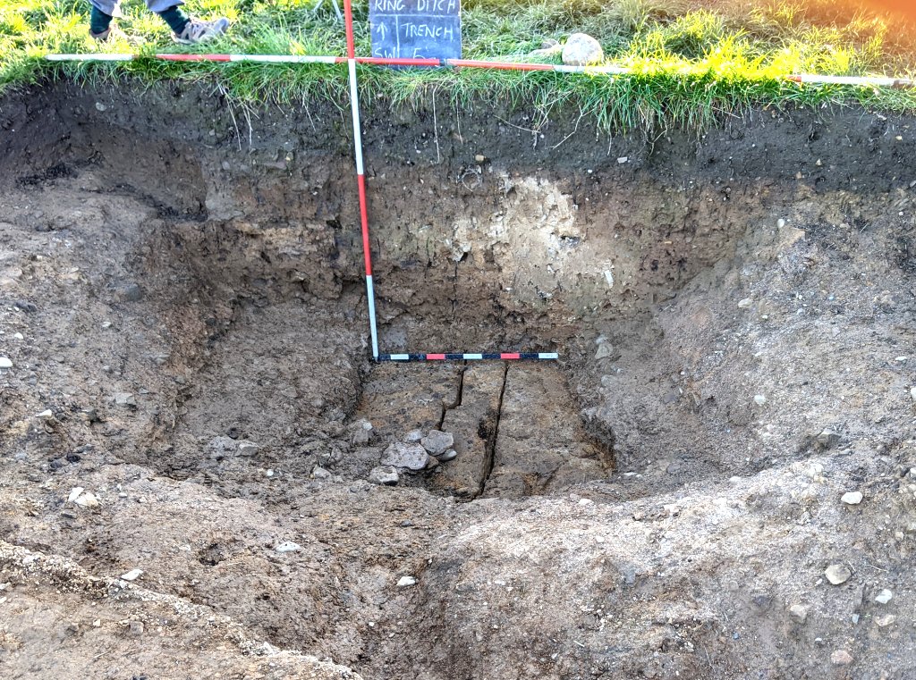 At the same time John worked on the end wall of the terminus in Trench 5 pushing back the baulk to reveal more of the bedrock the ditch was cut into. Both terminal ends are now looking more squared off rather than the bowl shapes we seem to have in Trenches 6a and 7.
 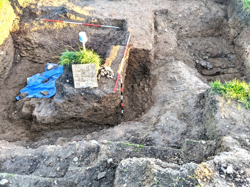 Meanwhile in the Trench 6a, as usual the ditch needed draining and once again Bill and Andy got a soaking trying to get the pump to work. The latest issue is with the connection on the suction pipe i.e. getting it to seal. With continuous use, the thread has worn down and the connector jumps the thread if over tightened (Andy has suggested replacing with a snap-on connector which Bill said he would explore).
Following on from Saturday’s visit, Bill was keen to try to understand what was happening to the bright soft clay layer on the west side of the cut, as there was no sign of an end to it. It was therefore decided to extend Trench 6a on the west side, i.e. remove the corner that had left in, down at least to the natural that had been originally revealed when the trench was first opened. Even after Bob’s careful trowelling though, it was difficult to see any change from this surface and the bright soft clay layer. A cut was therefore made into it, in effect extending the north wall section – but again, nothing could be detected. Without opening up more, this area is going to remain a mystery for the time being. 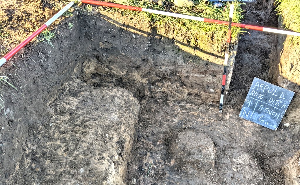 At the same time in Trench 7, Bill helped Andy in removing the remaining baulk so that the full profile of the terminus could be seen. This again proved to be difficult as the difference between the soft fill of the ditch and the natural clay was hard to see 9or feel). Despite the root damage though, there didn’t seem to be a ramp leading into the ditch here (which appears to be the case in the south terminus).
 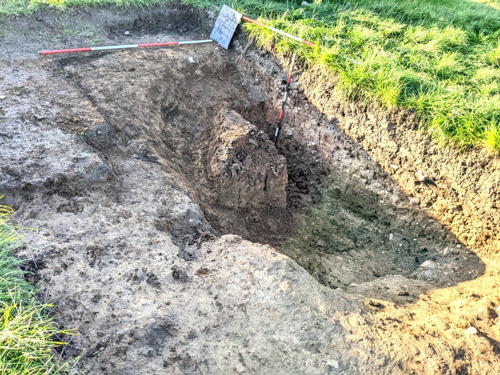 It would be good to get both termini finished and backed filled before the end of the season.
Saturday 8th October
Day 51 – Just three today, joining Bill were Andy and Christine Barbour-Moore. First job, draining Trench 6a. Chris was thoroughly entertained by this, watching Bill and Andy struggle getting the pump to work. This involved removing the top plug to feed in priming water, only to find it gushing out when it started, drenching them both in the process before the stopper could be replaced.
Getting back to the archaeology, Chris and Andy were given the task of giving the cut between Trenches 6a and 7 a good trowelling ready for photos and drawing. The reason for digging this section was to try to understand what was happening with the bright soft clay layer lying under the subsoil that was first detected when Trench 2 was dug. The trowelling revealed on the north side that this layer ended abruptly about a metre in from Trench 7 (indicated by the blue dotted line). The section south of Trench 2 however was not so clear. It seems though that the bright soft clay layer follows the natural as it dips into the terminus. The fill of the ditch lying under the subsoil more or less does the same, meaning that the subsoil tapers out to nothing by the time it reaches Trench 2. This means the dark brown layer seen on the this side of Trench 2 on Day 6 was in fact ditch fill (we weren’t of course to know this at the time).
 Meanwhile Bill set about removing the rest of the material from the north wall of Trench 6a (east of the cut) down to the natural, again ready for photos and drawing. Chris had to leave at lunch time but before she did she gave this area a good trowelling while Bill removed the material on the west side of the cut. Chris’ trowelling revealed the natural surface sloping gentle upwards away from the cut (yellow dotted Line). The bright soft clay layer follows suit, until it disappears at about two metres from the cut, leaving just the subsoil beneath the plough soil (light blue dotted Line). The ditch fill, as defined by the iron pan, runs out after about a metre.
 On the other side of the cut the ditch fill seems to be rising but the bright soft clay layer doesn’t show much sign of running out, even when the end of the trench is reached (need to look at the west wall next time).
By the end of the day Bill and Andy were able to draw this section and the east wall of the cut (this included a section through Trench 7).
Thursday 6th October
Day 50 – Wow! our fiftieth day – but only a few on site to celebrate as both Patrick and Chris on holiday and Steve otherwise engaged. So joining Bill today were just Andy and John Smalley – with Bob and Martin joining later in the afternoon.
As the weather is getting wetter and the end of the digging season is coming close, the big priority is to finish the work on the termini – in particular Trench 6a which fills up with water and won’t survive the winter. All other trenches are fortunately free draining and therefore can be left open which Nick, the farmer, is happy with (as the site is well fenced off). After once again, after draining Trench 6a, John and Andy finished cutting the trench connecting Trench 6a with Trench 7.
Andy worked in the area where Trench 2 crossed the cut, taking the backfill out to reveal the northside section of Trench 2. It was important to see this to remind us about what we had originally recorded there (reported on Day 6 in April) i.e. three layers above the natural, plough soil, subsoil and another bright soft clay layer.
Meanwhile John worked on the northside, coming in from Trench 7 to chase the natural surface i.e. a bright orange hard layer laying under the subsoil (the natural in Trench 7 seems much higher than in Trench 6a). John found that the natural soon disappear to reveal the greyer soft clay layer, presumably the same that Andy had exposed in the section of Trench 2. It was decided to take of photo of this before taking this layer out (by this time Bob had arrived and was tasked with trowelling the rest of natural surface in Trench 6a).  Bob’s excellent trowelling also removed the soft material from around the edge of the terminus revealing a more gradual entry from the natural into it.
 In the meantime Bill was looking at the outside edge of the ditch in Trench 5 (where Patrick had discovered a niche in the bedrock). He decided to extend it westward to show how the bedrock curved rose up and curved round forming the terminus (it would also allow water to drain out of the pocket created in Trench 5a).
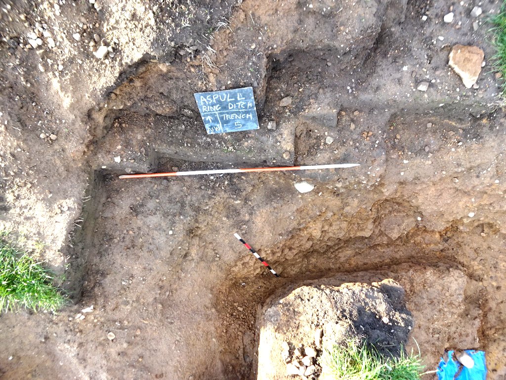
 Bill asked Andy to set up the dumpy so that he could do some levelling while he set about cutting through the baulk in Trench 6a to allow the water to drain out of the pocked on the east side. John meanwhile was tasked with taking out the bright soft clay layer on the Trench 7 side of the cut down to the natural (as found in Trench 2). This was so that the section could be drawn. When Martin arrived, he took over on the Trench 6a side of the cut to chase the natural from Trench 2 down to the level found in Trench 6a.
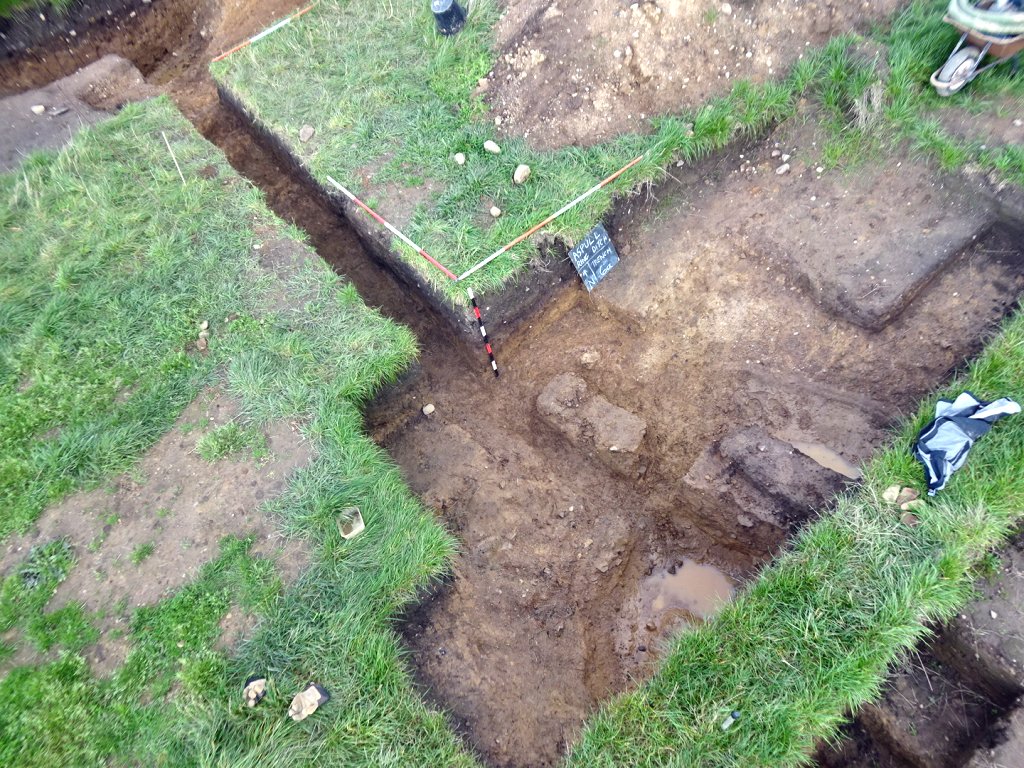 As mentioned before, this area is becoming very interesting as the iron pan layer on the north side of Trench 6a, shows the fill of the ditch extending beyond what appears to be the terminus. Now we can see that the ditch fill is overlying a layer of the bright soft clay (which must be the same as the layer detected in Trench 2 stretching over the entrance). This seems to indicated that this layer, not only continues towards internal mound, but also extends down into the terminus – when the ditch was backfilled, this layer was buried with it.
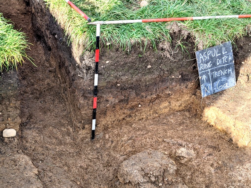 The big question now is, If this bright soft clay layer is what the mound is made of, where did this material come from as it is certainly not the same as the ditch fill – and also where did that material come from if not from the mound?
Thursday 29th September
Day 49 – Bill back this week and joining him and Chris today were Andy, John Needle and Martin (Patrick off on his hols). The priority today was to find the outer edge of the ditch in new Trench 8. To do this we needed to extend the trench northward by about a metre. After helping him to remove the topsoil John was tasked with trowelling down the subsoil. It wasn’t long before the tell-tale change in the sandy clay began to emerge form the hard compacted surface to the softer fill of the ditch. It wasn’t 100 percent clear though so John was asked to dig out the ditch fill further in, where the material was so soft it was easily spaded out, and work his way towards the outer edge. Assuming he has found the outer edge the ditch width here is about 3.7m which is in line with most of the others.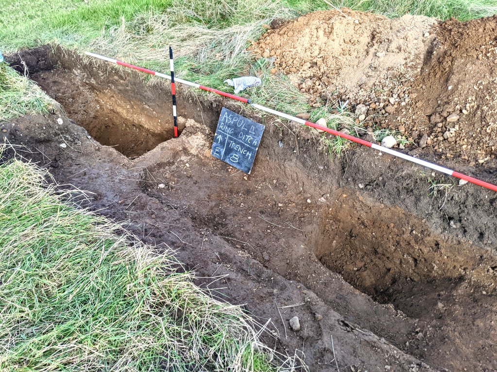
Chris set about cleaning the outer wall of Trench 5 where Patrick had discovered a strange alcove in the bedrock.
Meanwhile Bill and Andy had another go at draining Trench 6a using the pump (when it gets going it works really well but need to make sure the inlet hose is on properly).
Bill was concerned about the iron pan layer showing in the north wall of the trench. In all other areas were this phenomena had appeared, it was demarking the layer between the subsoil and the fill of the ditch. This would suggest that even here, which was less than a metre away from Trench2, we still had ditch fill (which seemed to be confirmed when Bill excavated the trench so that he could draw the section (Day 46). No ditch or fill layer was detected in Trench 2 so there must be a rapid change occurring between the north end of Trench 6a and Trench 2. It was decided therefore to excavate a trench between the two, in effect across the south side of the entrance. It was a daunting task to do manually but Bill and Andy were help by Martin when he arrived. By the end of the day, the cut had reached well into Trench 2 which was revealed in the section. Bill had just enough time to trowel the base and clean the section ready for drawing next time.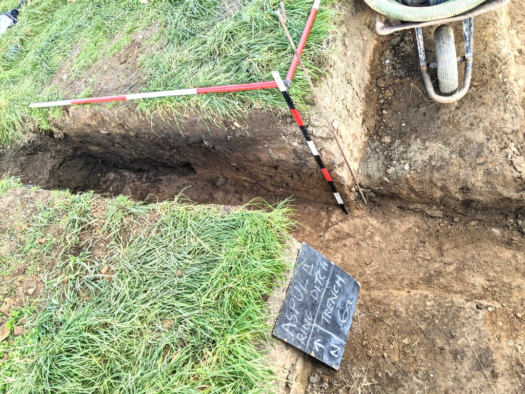
While Bill cleaned up the section, Martin was asked to start a similar cut on the north side of the entrance so that a full section of it can be drawn.
Saturday 24th September
Day 48 – Better weather today. Joining Chris were Denise (Chris’ partner), John Needle, Martin, Patrick and another newcomer, Christine Barbour-Moore. We also had help today from Phil Cox and Penny Jones, a couple of Chris’ colleagues from the BHAG (Borders Heritage and Archaeology Group). It’s over ten years ago that we first met Phil when he took us around his excavation site a Bryn Alyn near Wrexham.
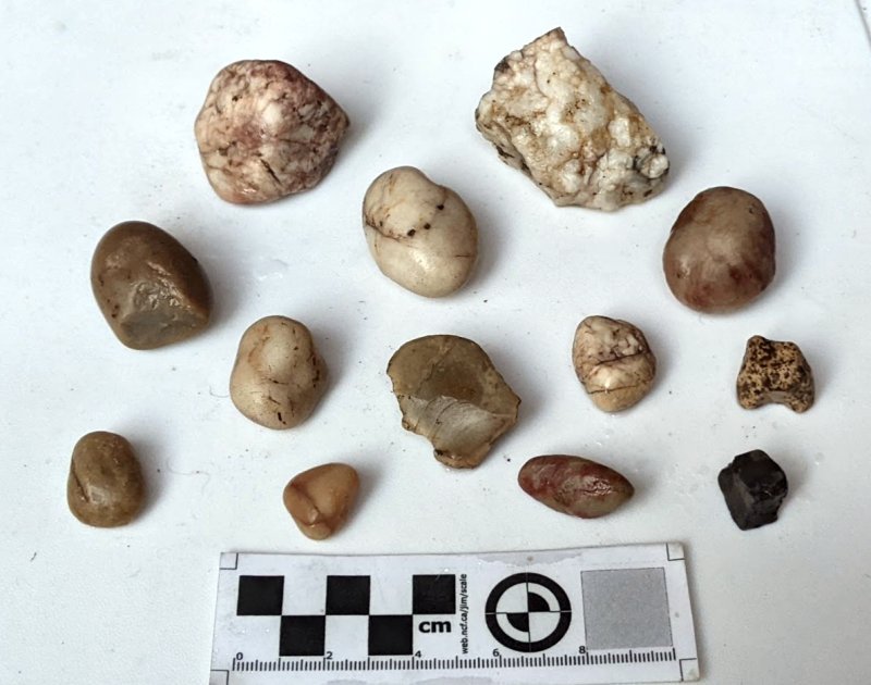
The floor of Trench 5 was cleaned and the stones covering the burnt wood exposed. The wall running between Trench 5 and 5a was clearly exposed so we can now see how the ditch curves round and does not join up with the section of the ditch running from Trench 7 to 5a. A strange looking stone came from the bottom of Trench 5. The one thing you can say about it, is that it did not need cleaning as it came out of the ground clean, polished and smooth and ever so tactile.
 It’s one more to be added to a growing number of small stones made from ‘exotic’ material (collected by Andy). They could be just glacial erratics but could also perhaps have some significant ritual purpose.
 John and Martin found the inner edge of the ditch in new Trench 8, about half way across the trench. This suggests that the northern edge of the ditch is flat/straight as the crop mark suggests.
A drone survey of the site and Trench 5/5a was completed at the end of the day. The resulting image clearly shows the wall between the two separate ditches. What it also reveals is that the wall in not continuous with a shallow groove being cut through it connecting the two. 

Thursday 22nd September
Day 47 – Bill away again this week so Chris was in charge. Joining him were
Patrick, Andy, Steve and Bob. They worked to complete the joining up of Trench 5 and 5a, removing the steps in the centre of Trench 5, cutting a new set of steps. By joining up the outer ditch wall between Trench 5 and 5a the shape of the ditch terminus could be clearly seen. Rain stop play after 1.5hrs.
Thursday 15th September
Day 46 – Again just five today with John Smalley replacing Steve and newcomer Ian Trumble replacing Patrick in the afternoon. Chris immediately set about pulling back what seems like the terminus wall of the ditch in Trench 5a, while Andy looked at exploring more of its outer edge. Chris noticed that the ridge running across the ditch from its outer edge, seemed to be dipping down only to re-emerge to form the rest of terminus wall. Meanwhile John worked in Trench 5 looking at extending the inner edge in towards 5a.
Bill was concentrating on Trench 6a as he wanted to get a section drawn of the terminus before it was too late. Unlike most of the other trenches, this trench was particularly susceptible to filling with water. It therefore would need to be backfilled before the end of the season – the others would survive the winter but not this one (it had already been emptied once and was now quite full again). Bill had brought the petrol water pump which rapidly drained the water out (a new spark plug proving its worth) but left a messy sludge in the bottom. After clearing this Bill set about cleaning out the bottom of the ditch which had a nice flat bedrock base (similar colour to that in Trench 5a). By the time he got to the section baulk left by Chris however, the ditch seemed to be on the rise, suggesting the section baulk was not on the ditch centre.
When Ian arrived, Bill asked him to finish cleaning out and trowelling the other side of the baulk. Once done Bill asked him to also put a cut into it, to see if there was some correlation with what he was getting on the other side of the baulk. Bill showed him the iron pan layer in the north wall of this trench, as reported last month on Day 41. Steve Hewitt had explained in his visit that this type of phenomena occurred when minerals leached out to for a layer of oxide. This was not from above however but from below i.e. from the fill of the ditch. Bill realised therefore that there was still a substantial depth of fill even at this point on the north wall of the trench. He needed therefore to chase it down into the ditch before he could get a complete section. By the end of the day he managed to get the full section across the trench but it was obvious something strange was going on here – therefore more trowelling would be need for this terminus to be fully understood (hopefully before it gets full of water again).
In Trench 5a Andy had gone as far as he could pushing the outer edge wall further out before he would need more top soil and therefore spoil heap to be removed. John had also managed to pull back the inner edge in Trench 5 which was looking like it was rising to match what had been found in Trench 5a. Andy pointed out that, before Patrick left the day before, he had seen something similar on the outer edge. He’d come across what seemed to be bedrock cutting across the ditch just above the stony layer uncovered earlier (Bill had not seen this). It became obvious to confirm this was bedrock, we would need to remove the baulk left between the two trenches which mean removing once again more of the spoil heap. With some help from Bill and Ian this was done enough to allow Andy to start removing the baulk (at least it would allow Andy to properly chase the outer edge in Trench 5a).
Wednesday 14th September
Day 45 – Just five today – joining Bill and Chris were Steve and Andy, with Patrick arriving later. With Trench 5a now opened up it was decided to concentrate on the the problem of the mismatch between it and Trenches 5. While Bill and Andy looked at extending the outer edge in Trench 5a towards Trench 5, Steve and Chris worked on the inner edge in Trench 5a. When Patrick arrived he set to removing the fill from the outer edge wall in Trench 5. This proved difficult as the lack of bedrock meant he was relying on the change of texture of the clay. Eventually he came down onto a stony surface which he thought maybe the base of the ditch although it was a bit high.
To extend the outer edge in Trench 5a Bill and Andy need to pull back more top soil. Andy was struggling to identify the edge so Bill suggested digging down into the fill to see if it was more identifiable lower down. After some effort to do this, Andy was given enough room to find the edge. In doing it Bill was also able to reveal more of the ridge running across the trench marking the junction of the the two ditches. He then set about extending the inner ditch in Trench 5.
Meanwhile Steve made good progress chasing what looked like the terminal end of the ditch in Trench 5a, while Chis cleaned the top inner edge to reveal its shape in the southwest corner. Steve also got chance to clean out the bottom of the ditch to reveal more bedrock (with a curious fissure in it) and more stones lying on top.
The overall view of the two trenches is now seemingly confirm that we have the junction of two separate ditches which are not quite inline. Chris’s research into causewayed enclosures suggest this arrangement is not unusual (only thing is these enclosures are always much bigger than our ring).
Saturday 10th September
Day 44 – Good turnout again for a Saturday. With Bill and Chris today were Steve, Andy, Peter with Patrick and Martin joining later. Also in the morning we had a visit from Ashley Brogan who cast her professional eye on our efforts. She wanted to compare our site with a site near Bury she had recently been involved with, which had been descried as hengeform but as yet undated (she had to admit though that ours is bigger).
More Resistivity. While she was here Bill asked Ashley if she would help him with an experiment with the resistivity meter. The result from last Thursday’s survey was disappointing but Bill thought that perhaps we could improve on the result. The procedure we used involved using a method known as a Wenner configuration which measures the absolute resistivity in the area around the probes. This wasn’t the usual way we did our surveys – ours system is geared to using the dipole method. This compares the resistivity of the survey area with the readings from remote probes. This gives relative values and has given us some success in the past. Bill’s experiment was to seen if using the remote probe method would give a better result. With Ashley’s help, he took a number of readings in the area where we knew the ditch to exist and an area beyond where in didn’t. It could be the dry weather followed by the recent rain that was effecting the system but the results were again disappointing with no discernible difference (the experiment at least prevented us wasting another morning doing a full scan).
In the meantime Patrick and Chris were pondering what to do with Trench5a which was tending to show a junction of two ditches. To understand this better it was agreed we need to open up a much bigger area. The prospect of doing this manually was to daunting so Patrick saw if Nick the farmer was available. Fortunately for us he was and said he would be up later in the morning.
While waiting for Nick, the team began removing more of the spoil heap in anticipation. They also took the opportunity to join the 0.5m test pit to the adjacent Trench 5 thus enabling more of the burnt wood feature at the bottom of the trench to be exposed. It also enabled the the outer edge of the ditch in this trench to be extend.
When Nick arrived he very skilfully removed the topsoil without spoiling the trowelled area at the bottom of Trench 5a. 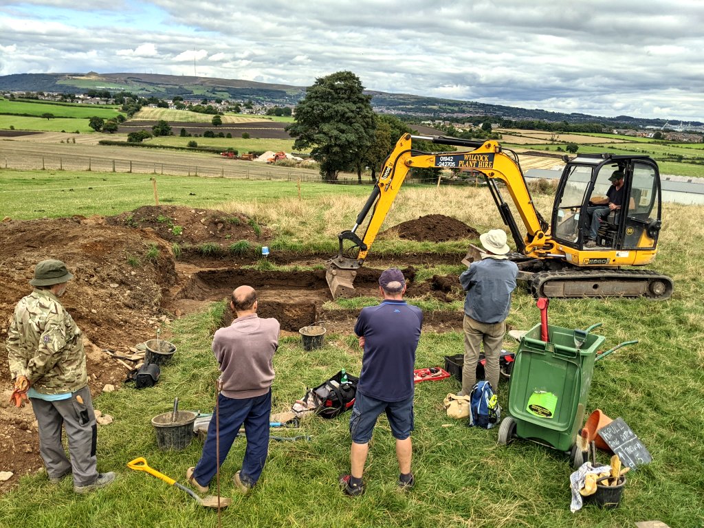 In fact he was able to expand the trench till it eventually connected up with Trench 5.
 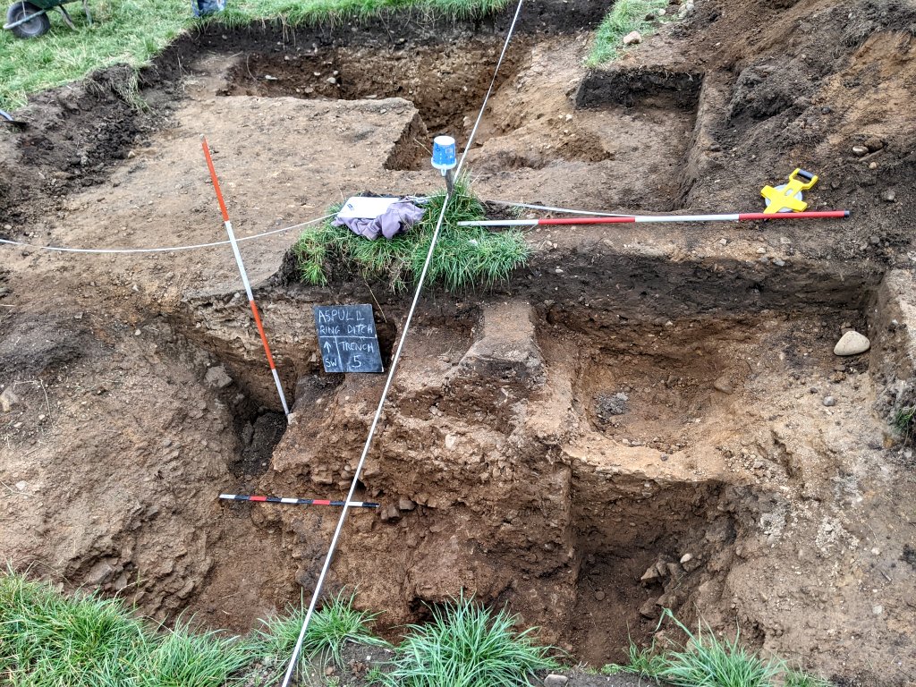 We then asked him to open up a new trench, Trench 8 on the north side of the site to confirm the shape of the ditch in this area. We had earlier carried out some augering in this area which had suggested the ditch was much further in than previously assumed. The trench Nick opened was 7.7m x 1.3m and straddled the datum line starting .7m south of Peg 16. There did appear to be a colour change on the north side suggesting the ditch was further north than anticipate, Further augering by Bill and Andy seemed to confirm this – once again casting doubt on the reliability of the this technique for prospecting for the ditch (but with the failure of the resistivity, is our only option at the moment).
Thursday 8th September
Day 43 – Joining Bill and Chris today were Andy, Peter and John S with Patrick and Bob joining later. Heavy rain over the last few days had made Trenches 6, 6a and 7 unworkable with a good deal of water in the bottom. It was decided to concentrate on Trenches 5 and 5a to try and sort out the apparent discrepancy between the outer edge of the ditch in Trench 5 and the outer edge of the ditch in Trench5a. Chris and Peter were given the task of removing the subsoil exposed last week in Trench 5a so that the outer edge of the ditch could be better seen in this Trench.
In the meantime Bill had brought his petrol strimmer and Andy was given the task of giving all the trenches a ‘hair cut’ so that they could be better seen from Chris’s drone and also safer for people walking through the long grass.
Pseudo-sectioning. We had a committee meeting last Thursday where it was decided we had to find a another way of identifying where the ditch was in areas yet to investigated, as it was going to be impractical to be putting more trenches in with the limited time we had left this year. Augering had help but had been found to be misleading in some areas. More resistivity had been suggested and Bill had mentioned a technique called pseudo-sectioning which uses resistivity to scan vertically down into the ground. He added however that his experience with it had not been good but was willing to give it a try on this site. The technique involves inserting 20 odd steal probes across the section to be tested and then using the meter to take many reading from the probes in a specified manner. The method is manually intensive but with the help of four additional operatives the system can be completed in a reasonable amount of time. Still it took us all morning to complete two scan at 1m spacing and then 0.75m spacing on the same line (giving a section depth of 3.2m and 2.4m respectively). The result however, when processed, despite our efforts was once again disappointing. There was some correlation between the two scans but neither revealed anything that could possibly be described as indicate a ditch. Ah well at least we tried (seems we’ll be back to relying on the auger).
Back to Trenches 5 and 5a – by mid afternoon Peter and Chris had revealed the outer edge in the latter. It was obvious though that we needed to expand the trench once again to chase the edge towards Trench 5. This however was not going to be easy due to the unfortunate location of our spoil heap which had ended up there because we had not anticipated the ditch to be this far out. We decided to grasp the nettle and managed to push it back enough to give some space to expand Trench 5a. It also allowed for a 0.5m wide test pit next to Trench 5 to look for where the outer ditch edge was going in that area. By the end of the day Bob and Bill had managed to get down below the sub-soil which allowed the ditch edge to be identified.
The expansion of Trench 5a was just a spade’s width on the northwest side but this was enough to reveal more of the ditch edge. However it was becoming apparent that we had a ridge running across the ditch. This suggested, strangely enough, that we had two terminals coming together (a junction perhaps of two working parties) which would perhaps explain the mismatch between the two trenches.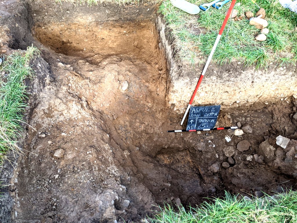
As this was being carried out, Andy and Bill cleaned out the bottom of Trench 5a where the bedrock had previously been revealed. The colour of the bedrock here is bright orange for some reason and Bill was able to examine a band of soft back material seemingly embedded in it (this had previously be reported by Steve when the ditch was first excavated). Bill thought it looked like rusted iron but couldn’t possibly be as it was embedded in the rock.  John S later emailed that whilst it was probably not iron per se, he thought it was some iron compound given that Trencherbone Sandstone is known to have deposits of iron compounds between the leaves of rock (he also explained how you could test for it).
Wednesday 31st August
Day 42 – Only one day this week but another good turnout – joining Bill, Chris and Patrick were Steve, Andy and Peter with Bob and Martin joining later on. Chris got stuck in straight away working on his the burnt wood feature in Trench 5. His attempt at getting a series of images to create a 3D model last week had fail due to the shadows but today the lighting was just right. That done, Chris resolved to reveal more of the feature but before starting he took the opportunity to remove a small sample just in case we need to send off for another C14 date.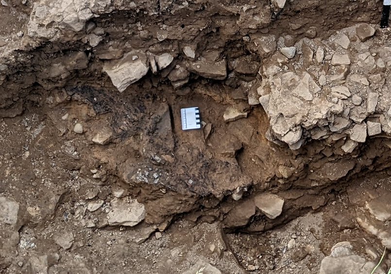
The discrepancy between the outer edge of the ditch in Trench 5 and the outer edge of the ditch in Trench5a was still puzzling. During our last session Bill had carried out some probing of the surface outside the outer edge of the ditch in Trench 5a. This seemed to suggest the there was bedrock 10 or 12cm below the surface. He therefore ask Andy to open up a sondage to test the theory. Sure enough the bedrock appeared at the suspected depth (it was a surprise to find bedrock here as none had appeared in Trench 5a except at the very bottom and even in Trench 5 it was quite low down). Bill therefore asked Andy to expand the sondage towards to see why we hadn’t detected it when digging out Trench 5a’s ditch fill. Pretty soon he reached the edge of it and not surprisingly was outside where we had previously perceived edge to be. Chasing it down into the ditch, Andy could also see that it was angled more northwards (this was encouraging as it seemed to be heading more towards the outer edge in Trench 5). Bill helped Steve therefore to open up Trench 5a to see if we could follow the outer edge towards Trench 5.  When Steve eventually came across the edge on the northwest side of the trench, he proceeded to chase it towards Trench 5. This didn’t however go to plan as suddenly the edge began to turn outwards suggesting we had an abrupt change rather than a smooth transition (obviously we need to open up more of this area).
Meanwhile Patrick decided to persevere in Trench 7 to see the profile of the terminus could be better determined. Pockets of soft clay in some areas and the baking of the surface in others was making this particularly difficult. The area where we suspected the rotted tree root to have been was also not helping.  At the same time, in Trench 6a Peter had been tasked with expanding the cut he had made last week on the west side. Gratifyingly this produced the nice bowl shape we were expecting representing the terminal of the ditch. Peter then turned his attention to the bottom of the ditch and digging out the fill up to a central line Chris had marked out with a string. When Bob arrived, Bill helped him to dig out the east side of the terminal leaving a baulk in the middle. Again a nice bowl shape was revealed.
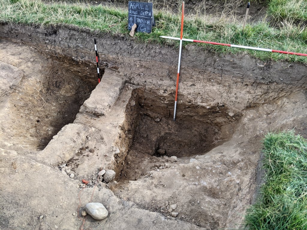
Bill had invited Steve Hewitt to come and give his assessment of our site. Steve used to teach geology and archaeology at Wigan Tech so is quite well placed to give us his opinion what we have discovered. When he arrived Bill gave him a tour of the trenches. As expected he intrigued with Trench 3 where an area of loose stone filled what seemed like another ditch outside the main ditch. The question is, is manmade or natural? Steve’s comments were that, as this was random rubble, his first impression was that it was a manmade. However he couldn’t be 100% certain of this and could envisage the possibility of it being the result of glacial action (the jury is still out). Steve also reserved his judgement of the site as a whole, the only thing he would admit to was that it was ‘ceremonial circle’ of some kind.
Thursday 27th August
Day 41 – Great turn out today with John N, Andy and Bob joining yesterday’s team of five. Not seen Bob for a while but he was happy clearing the vegetation that was starting to grow in Trench 1. Chris continued to investigate the burnt wood feature in Trench 5, revealing more of it by removing the cobble lying on top of it. Steve, also in Trench 5, got stuck in to trowelling down the outside wall of the ditch which Bill had been trying to reveal the day before. This came up quite nicely revealing the bedrock that the ditch had been cut into. The only problem was it didn’t show any indication of a turn towards the ditch in Trench 5a. In the meantime Peter, in Trench 7, had another go at finding the the west wall while Patrick tried to expose more of the bedrock showing at the bottom of the ditch. This was proving difficult in the restricted area. Bill was wondering however about the fact that, unlike all the other trenches, no bedrock had been exposed in the wall of this ditch (as was true in in the other terminus i.e. Trenches 6 and 6a,). Bill was a bit worried that the hole exposing the bedrock in the bottom of the ditch may have cut through the the actual bottom of the ditch (meaning the top of the bedrock layer is below the ditch and therefore not defining it). There was certainly a harder clay at the bottom of the ditch but this had large cobbles embedded in it, similar to Trench 5a. Peter and Andy were confident that the fill they removed from the hole to reveal the bedrock was quite soft.
It was decided that, to get a better idea about what was going on we needed to expand the area by taking out one of the quadrants of the terminus. As we were confident we had the east and south walls, the east quadrant was selected for removal. By the end of the day however things hadn’t become much clearer as we ended up with quite a raggedly shaped outline – not much of the bowl shape we’d expected. Much black staining had emerged in the loose fill and this, together with the dark feature at the very south end, suggests that this area had been effected by tree growth. This seemed to reflect what Chris found in the north section of the ditch in Trench 6a, (were the terminus ends marked with trees one wonders?). Bill and Patrick also had some concerns with Trench 6a. Previous work had revealed the bedrock at the bottom and not far above it, a nice bowl shape had been revealed, cut into the hard clay, defining the west quadrant. However above that there was nothing to show the shape of the terminus either on the west or east side.
Looking next door in Trench 6 (maybe due to the drying out of the soil) Bill could see a thin layer of iron pan in the form of a red oxide line in the north wall (not easy to see in the photo). This seemed to be defining the bottom of the subsoil layer which lay below the plough soil (marked with a white dotted line in the photo). The subsoil dips down reflecting, as in other trenches, the underlying ditch (maybe caused by settling of the backfilled material). Iron pans are caused by the leaching out of iron oxide in the soil which gets trapped between layers. An iron pan line could also be seen in the north wall of Trench 6a, but no dip in the subsoil here as it’s not far from Trench 2 where there was of course no ditch.
  Looking at the south wall of Trench 6a there is no iron pan showing, but the subsoil can been seen quite clearly, dipping as would be expected, reflecting the ditch at this point. It can also been seen that the dip stretches all across the exposed trench. This would indicate that the edge of the upper ditch edge on either side has not been exposed (which seemed to be confirmed by comparison with the ditch in neighbouring Trench 6).
 It was therefore decided to extend the trench on the west to match Trench 6 and also take down the level on the east side to expose the edge of the ditch on that side. After de-turfing, Peter set about cleaning the surface looking for the wall on the west side. This he eventually achieved by working up from the bottom (from the know to the unknown) revealing more of the shape of the terminus here.
 The bowl shape is now well defined but the bedrock seemed to appear below the shape (are we seeing a recut here – which may perhaps explain what we’re seeing in Trench 7)?
In the meantime Bill set about removing the remaining plough soil and ditch fill on the east side. Eventually the eastern edge of the ditch was revealed. This became quite clear after some neat trowelling by John N (although not showing very well in the photo). Hopefully the bowl shape will be revealed when more of the fill is removed. 
As mentioned before, Chris has been interested in the possibility of an ancient lake in the Borsedane Brook valley. With this in mind, he and Patrick set off to try to trace the possible edge. They were assuming the back layer exposed in the new fish pond was the edge from which they could followed the contour. They found that the monument would have been prominent on the skyline all along the western bank of the theoretical lake, but not so much on the eastern edge.
With dark clouds looming, it was decided to pack up a little early to avoid a soaking. However before we left we were able to carry out some augering on the north side of the north/south axis. Previous augering here 20m out from Peg3 (suggested by the possible oval shaped ditch) had failed to detect the ditch. The crop marks showing on the aerial photos however suggested the ditch is definitely there but further towards the centre. Todays augering session seem to confirm this, showing the ditch to be between 14.5m and 18.5m from Peg3 (although less than a meter deep) – of course only an excavation will prove it. If it is true (and it does happen to match the aerial photos) then the shape of the ditch is looking quite irregular in this northwest quadrant.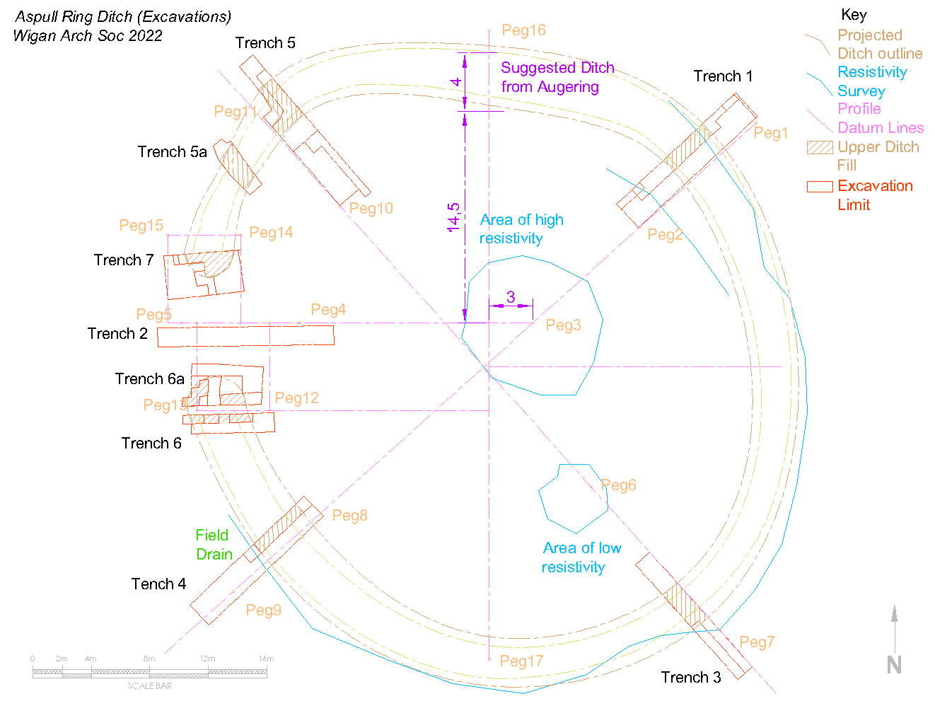
Wednesday 25th August
Day 40 – Bill back from his hols, so joining him were Chris, Peter and Patrick. While Bill was away, our equipment was stored in Nick’s workshop which we will continue to do as it saves Bill having to bring it every time.
Before finishing off last week, Chris had cut a new set of steps on the southwest side of Trench 5. This was so that we still had access once the fill had been removed above the burnt wood feature he discovered last week. After examining the outside edge of the ditch and how it might line up with the ditch in Trench 5a, it was decided to widen Trench 5 to expose more of the ditch’s outside edge (to see if a turn could be detected similar to the inside edge). Bill set about the task of removing the ditch fill in this area – this would also help Chris to examine more of the new feature.
Chris had already started on this, bringing down the level to the top of the loose cobbles lying on top of the feature.
Steve got going on removing the stones from his ‘water feature’ after Bill had recorded them for posterity ( Bill and Patrick both were sure this wasn’t a feature, just random scatter of stones).
In the meantime Peter was tasked with cleaning the west side wall of the ditch in Trench 7. The previous week, Andy had exposed the east side wall which although difficult to see after the rain, was quite well defined (as was the previously exposed south wall) – there was no cut the the bedrock, just hard clay defining the ditch.  However the west wall was not so clear as soft fill material was still coming off the surface. There was also an issue of the very end of the south wall were Andy had detected a dark feature cut into the clay. On closer examination there was a cavity in it stained back, suggesting a rotted tree root.
Thursday 18th August
Day 39 – Just the one day this week but progress made on both termini, and in Trench 5 and 5A. Bill on his hols again so joining Chris were Steve, Andy, Peter and Patrick.
Initially work was carried out in Trench 5 to cut new steps to allow more or the ditch floor to be exposed. However work was halted when a strip (at least 50cms) of burnt ‘wood’ was exposed. There is an interesting sequence here. Sat on the rock floor, is a grey clay layer, then orange sand layer, then the burnt ‘wood’, then another layer of orange sand, then small loose rock fragments/pebbles after which the usual ditch fill. This area has now been covered ready for further investigation.
 Steve worked some more on Trench 5A and confirmed he had found the inner edge. The ditch actually looks to be only 2.5m wide here (assuming we have the outer edge) but this inner edge links to Trench 5 better (still no sharp turn yet to get to Trench 7 though). Patrick, Peter and Andy opened up more of Trench 7. Later on Peter moved on to Trench 6A and took out more of the ditch fill. Chris carried out more drone surveying and later produced a detailed coloured topographic image which will be very useful for Bill’s plan drawing.
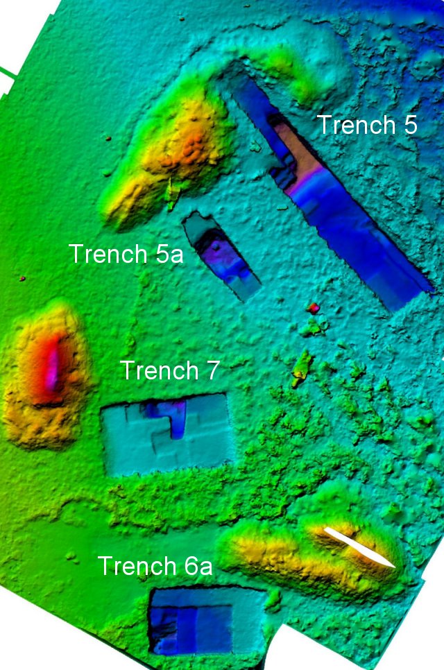
Nick the farmer also mentioned that he had started to open a new fishing pond extension to the northeast of the farm and had to stop as he had found a ‘dark layer’ on top of a sand layer. Patrick and Chris went round to have a look as this could support a theory that the fields east of the farm were once a lake/marsh. Chris is currently working on QGIS to analyse different flooding levels of this landscape but if this is shown to be true, it could be one explanation for the location of the monument.
Thursday 11th August
Day 38 – Another scorcher today – same team as yesterday except Chris instead of Andy (and no Patrick). We were accompanied by a brace of pigeon shooters in the next field (Nick had invited them as the flocks were becoming a nuisance – only thing was they were shooting in our direction and, although a whole field away, Steve swore he could hear shot falling in the grass around about).
The only thing to do in Trench 5a was to see if the inside edge of the ditch could be located so Steve cracked on by extending the trench about 90cm inwards. When the turf had been removed Bill put did some aurgering which seemed to suggest the edge was in this area (aware however that he had been deceived before). By the end of the day (which came early do to the heat) Steve was confident he had the edge. This however made the ditch just less than 3m wide at this point which is the smallest so far. Peter worked in Trench 7, trowelling out more of the soft fill to reveal more of the clay and stones in the bottom. It was decided to remove the clay (which turned out to be 10cm thick) which revealed the flat bedrock underneath.
Meanwhile Chris and Bill persevered in Trench 5 to eventually reveal the inner edge of the ditch across the full width of the trench. This seemed to show a flattening off or maybe a slight curve but not the sharp turn that was perhaps expected to get inline with the ditch in trench 5a (the newly exposed inner edge in 5a however was not as far in as expected so maybe a sharp turn isn’t needed).
During our break for lunch Peter spotted our first piece of flint (or more likely chert) sticking out of the topsoil of Trench 5a. Not a tool but maybe a piece broken off when a tool was being made.
Wednesday 10th August
Day 37 – Just four braving the blisteringly hot day (37 in the shade apparently). Joining Bill were Peter, Steve and Andy (with Patrick arriving at lunch time). Steve got going straight away in Trench 5a, trowelling back the northeast wall towards the outside edge of the ditch. This confirmed that the large stones in the bottom of the ditch continues right up to the edge – and also revealed that the hard stony corner, which seemed to suggest the edge was turning in, was lying on top of softer material, thus showing this was no the case. Steve continued by investigating the south side of the trench. This revealed a series of stony layers, almost like steps (Bill suggested a water feature and for a moment Steve took him seriously). It was difficult to tell though whether these had been deliberately placed or if it was just they the ditch had been backfilled. What was significant was the that the large stones were almost exclusively rounded cobbles i.e. not from the local bedrock. Where had they come for and why and for what purpose had they been used on this monument?
Bill asked Peter to look at Trench 5 as the seemed to be a disconnect between it and Trench 5a – i.e. the projected alignment of the ditch in 5 seemed to miss the the ditch in 5a, or it made a tight turn somewhere between. It was therefore decided to chase the inside edge of the ditch in Trench 5 towards 5a (this would mean some hard digging but it seemed the best option).
In the meantime Bill helped Andy opening up a section across the ditch on the west side in Trench 7. It was noticeable that the fill of the ditch here was quite soft with few stones in contrast to the stony harder fill in Trench 5a just a few metres away. As Andy was reaching what appeared to be the bottom, the situation began to change and a thick clay layer began to immerge. Significantly this had large rounded stones in it similar to the situation in Trench 5a – it seems therefore that there is a connection between the two trenches.
Thursday 4th August
Day 36 – Joining Chris and Bill today were Steve, Andy and John N (with Patrick joining in the afternoon). Examining Trench 5a, it was obvious something strange is going on particularly in the north corner as the stony ditch wall seemed to be turning inwards. The only option was to expand the northwest edge of the trench. A string line was therefore set out to add another half metre and a protective sheet placed in the bottom to protect as best as possible the exposed archaeology. Once the thick layer of topsoil had been removed the going got difficult due to the stony condition of the underlying subsoil. It was easy to why we were thinking the wall of the ditch was turning in and perhaps this was another terminus (which would mean a another entrance and another terminus on the other side).
Looking at the large stones in the bottom however, it was obvious they were going underneath the overburden. More trowelling on them had started to reveal cavities which strongly suggests they represent a deposit. Either purposely placed or dumped, it means that the overburden must also be a deposit (i.e. not natural) therefore not another terminus (phew!).  Cutting down through the overburden confirmed that the stonework continues under the fill. But what about the outside ditch wall – was it turning in as the stony surface seemed to suggest?
 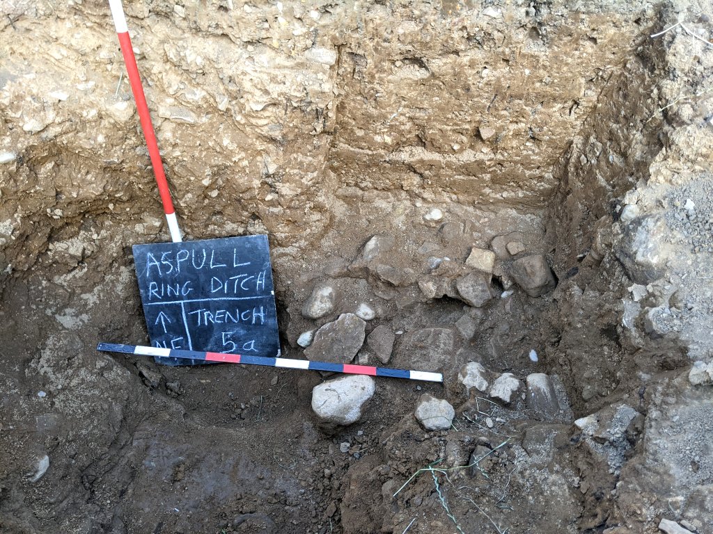 Bill decided to put in a number of cores using the auger on the northwest edge of the trench to see if the ditch was terminating in that area. The results seemed to suggest this was the case – however a small test pit soon proved this not to be the case as the stony condition of the subsoil was causing the aurger to give false readings (a lesson learned – the only way we’re going to understand what’s going on here will be to dig it out).
In the meantime Chris had been busy digging out the southeast corner of Trench 6a and trowelling the surface to reveal the profile of the terminus. He also realised he needed to realign his section to reflect a more central position and therefore a more accurate representation of its profile.
In Trench 7 Bill and Andy were also cutting out a section to get the profile of the terminus. Prompted by Chris, they also realised they needed to realign to get the best position (this may need another rethink). What is very obvious though is the condition of the fill coming out which is soft clayie sand. This is in contrast to the hard stony material coming out of the ditch in Trench 5a only metres away.
Once again Chris’s drone shot is able to summarise all the work we have done to date in the western side of the feature.
Wednesday 3rd August
Day 35 – Just Chris, Steve and Andy to day and work was concentrated on Trench 5a. After Bill had left on Thursday, Steve had continued to open up this trench and had come across some large stones at the bottom, not lying on the bedrock floor but embedded in thick clay. The work today was spent enlarging the hole so that this stone work could be investigated.
Thursday 28th July
Day 34 – Same team as yesterday except for Patrick who had to cry off and Bill had to leave just after lunch (Bob made an appearance just as Bill was leaving).
Steve was glad to get back into Trench 5a to see if he could find the bottom. This he achieved by opening the hole he had dug the day before and eventually got there just before lunch. Strangely this showed the bottom sloping up towards our new trench, Trench 7 (maybe the ditch was shallowing out towards the terminus).
In Trench 7, aggressive trowel finally produced the result they had been looking for, with a distinct colour change at either end of the trowelled area (difficult to see in the photo but it could certainly be felt by the trowel). Trowelling a strip at ninety degrees in the centre also produced a similar result seemingly to prove that this was the other ditch terminus. To confirm it Andy put in a series of aurger holes along the top edge and with the white tabbed sticks, was able to show the suspected profile of it.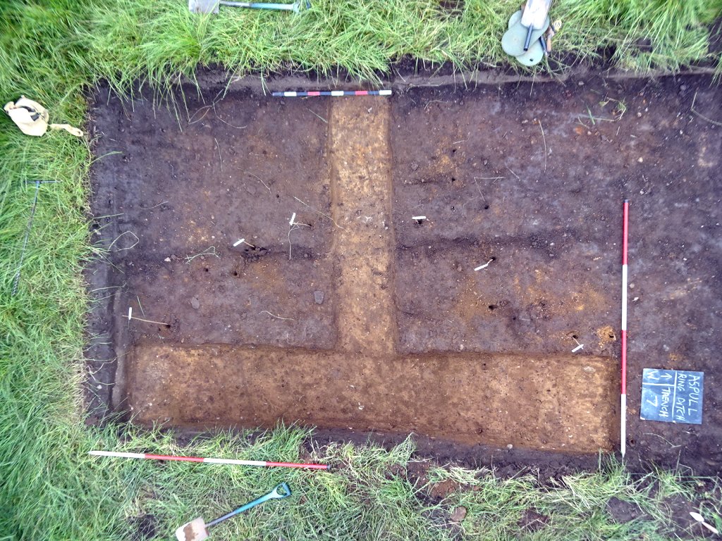 In Trench 6a, Chris was looking to do the same thing by trowelling a strip along the south edge and extending northwards. Previously he’d trowelled an area along the north edge where the the sandy clay seemed to be quite soft and was able to reveal some strange dark, almost hollow, strip features. These were interpreted as the remains of tree roots (taking a sample of the dark material in them may confirm this).
An entrance to the monument can now been confirmed (maybe there’s more, if the coring done by Bill on the north side is anything to go by) It seems certain now that this is something more like a henge than a Bronze Age burial mound. There may still be a burial in the middle though. Some research Chris has been doing, reveals that in the changeover period between the early Neolithic (when burials were the norm) and later Neolithic (when burials disappeared on the monuments), there was a period when henges contained burials (so fingers crossed for ours).
Wednesday 27th July
Day 33 – Joining Bill today were Chris, Steve and Andy with Patrick joining later. Steve immediately set to work looking for the outer edge in Trench 5a where last week’s coring had detected. By the lunch break he had uncovered enough to confirm we had the edge in this trench. He hadn’t reached the bottom but it was already quite deep with the edge wall seeming to curve around. 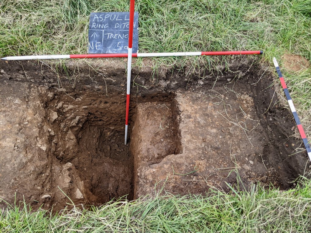 In the meantime, in Trench 6a, the digger had left us with as square in the southwest corner. It was decided to take this out before doing anything else, taking care not to allow too much spoil to fall into the bottom of the trench where the ditch edge had been exposed (to try to achieve a wheel barrow was positioned in the hole). By the end of play this corner had been removed down to the level of the rest of the trench.
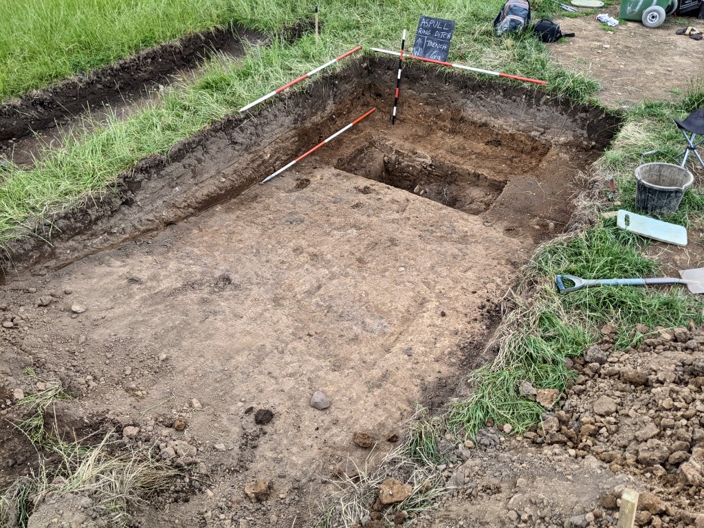
Looking at the new trench, Trench 7, it was decided to trowel a half metre strip on the north side to see if a colour change could be detected. When Chris became free, he joined Andy in this operation. Coring had suggested they were in the right area but any colour change was difficult to spot (more work needed here).
Tuesday 26th July
Day 32 – Patrick, back from his hols, joined Bill to mark out an area for another trench between Trench 2 and Trench 5 looking for the other terminus. Bill showed Patrick the coring done last week in and around Trench 5a which they were relieved to find did not indicate the terminus. Bill also showed him the coring in the area north of Trench 2 which seemed more positive. Two pegs were put in 6m north of the Trench 2 baseline 20m west of Peg 3. When the digger arrived (driven not by Nick but his 18 year old son Paddy) a new trench (Trench 7) 5m x 3m wide was opened 2m north of the Trench 2 baseline. They also asked Paddy to extend Trench 6a, which had been opened manually, a few metres eastward leaving a 60cm baulk between it and Trench 6.
 Having detected the possible outside edge of the ditch in Trench 5a, both Chris and Bill speculated on what shape would fit, as it was not where it had been predicted. Perhaps not surprisingly both came up with the same oval shape. Henges do come in all shapes and sizes and some are elongated but none are perfect ovals and invariably the entrance is on the long axis. It would therefore be quite something if it could be proved to be a perfect oval. With this in mind Bill put in two more pegs on the vertical axis 3m west of Peg3 20m north and 23m south of the Trench 2 baseline. If the ditch could be detected in these areas it would give more weight to the bizarre proposition. Initial coring area the northern peg failed to detect the ditch (so no need to get excited) – but where was the ditch in this area, do we have another entrance?).
Thursday 21th July
Day 31 – Five of us today – instead of John N though, we had Andy joining Bill, Chris and Steve, with Martin joining just before lunch. Chris and Steve were keen to continue work on Trench 6 and 6a but Bill said priority was finding the other terminus and so persuaded them to help open a new trench (Trench 5a) 3m west of Trench 5. The coring carried out yesterday seemed to show it was in this area (although some way from the other terminus).
The not particularly straight trench was roughly 2.5m long and 1m wide and took all morning to get down to the sub-soil. Before completing it though, more coring suggested that, although the outer edge of the ditch was there, the terminus was not (it looks like the aurger had been defeated by local stones instead of bedrock – which can happen). Martin, when he arrived, was keen to get going with his new trowel, so was tasked with carefully trowelling the surface to see if a colour change could be detected. There was certainly a change in texture and trowelling reveal a yellowish tinge outside the ditch and a darker brown tinge where the ditch was thought to be. It was difficult to capture on camera though as the surface was quick to dry out causing the colouration to disappear. Wetting the surface could not it so an attempt was made to capture the colours straight after a session of fresh trowelling. Sticks of the same length placed in the aurgered holes down to the level of the perceived bedrock also helped to highlight the position of the outer edge.
With no obvious terminus at this location, it was decided to carry out some coring where it was imagined the other terminus was most likely to be (somewhere to the north of Trench 2). After a number of holesaurger were taken, an area about half way between Trenches 2 and 5a seemed to suggest its possible location. This time it was decided to wait for the farmer to open a new trench to check this out (digging trenches by hand is not the best way to investigate this site).
Steve was returned to finish cleaning out the inner edge of the ditch in Trench 6 and Chris same in Trench 6a. The result was clear evidence of the terminus at this point and Chris’s drone shot was able to clearly show it. Again it was decided to leave further excavation here to Nick the farmer. 
Wednesday 20th July
Day 30 – Just the four of us today, Bill, Chris, Steve and John N – quite relieved that the temperature had dropped from the record 36 degrees the previous day but not sure what to wear as it was uncertain what the weather was going to do.
Having found the outer edge of the ditch in Trench 6, Steve was tasked with looking for the inner edge (we had a rough idea where to look from the coring previously done). Chris was given the task of looking for the edge of the ditch terminus we had possibly detected in Trench 6a last week.
Meanwhile Bill and John went off to do some prospecting around an area west of Trench 5 to see if they detect the direction the ditch was taking (due to the fact that the ditch here was a long way out of the predicted circular line). Bill had brought a bigger coring tool (one that was normally used for digging hole for fence post). It proved however pretty useless in the dry conditions as it was unable to hold and therefore remove the soil it was cutting. Bill and John therefore resorted to digging small holes with a spade to the depth of the sub-soil before using the 20mm auger to take cores and and then probe (which they had had some success with before).  Their first core taken 5m to the west of Trench 5 (on the predicted line of the ditch) did not show any sign of it. Cores taken 1m either of it also drew a blank. It was therefore decided to take a core 1m closer to Trench 5 but this also produced no evidence of the ditch. Their next core, taken 1m even closer to Trench 5, final produced the result they were looking for (the probe going in just over 1m). However the next core taken 1m to the north it produced another blank but two further cores taken at 1m intervals on the south side of it did produced further evidence of the ditch with similar results from the probe. The overall result is peculiar as it suggests the ditch makes a shape turn inwards before terminating (more investigation obviously needed here).
In the meantime Steve had located the inner edge of the ditch in Trench 6 and by the end of the day had chased it down to its base. This gave a depth of 1.5m and measuring from the outer edge, a width at the surface of 3.6m.
Chris has also been successful in finding the ditch edge in Trench 6a where we were looking for the terminus. He also reached the bottom showing the ditch in this area to be the same 1.5m as Trench 6. To investigate the full profile of the terminus however, Nick digger will be needed to open up the rest of the area.
Thursday 14th July
Day 29 – Joining Bill today were Chris, Andy and Steve with John N arriving later. Steve volunteered to finishing off Trench 5 and by late morning had the whole of the ditch exposed. Bill took his photos after Steve had given the section a good wetting (and waiting in vain for the sun to go in).  After the lunch break Steve and Bill set about recording the section in this trench. It revealed the ditch to be 3m wide at the top and 2m at the bottom with a maximum depth of 1.43m. This is the smallest ditch section so far revealed.
  In the meantime in Trench 6 Chris went looking for the possible outside edge of the ditch while Bill and Andy expanded Trench 6a to give them more room to dig. It was decided to go first further north then south, joining it up with the previously cut test pit making this trench now 2.85m x 1.35m. As mentioned before the topsoil is deep here and below it they encountered an even deep layer of sub-soil with no sign of the hard clay surface revealed in Trench 2. It was hard going but when John arrived, he was able to help dig this trench out. At close of play, coring and probing revealed the bedrock to be not much further down and rising towards the north (and Trench 2). It also suggested a more gentle slope than the usual ditch sides.
  Meanwhile Chris was making headway in Trench 6 and at a depth of about a metre seemed to have detected the bedrock ditch edge. When Steve became free, he took over from Chris and soon confirmed the stone-cut edge. Eventually he was able to chase this edge down to the bottom of the ditch showing it to be of a similar size to the other sections we’ve dug (if we can do the same for the inner edge we may be able to avoid digging out the whole ditch).
  It seems certain now that we have a terminus but will need Nick to expand or trench to get its full profile. Plotting the route of the ditch with the information we now have, shows it to be, as predicted, to be oval shaped (as are many henge monuments e.g Castilly Henge in Cornwall) but what is strange is that the position of the outer ditch in Trench 6 is not far from the predicted circle (less than a metre) – whereas the position of the ditch in Trench 5 is 5 metres away. This makes it asymmetrical ( i.e. a slight spiral).
Wednesday 13th July
Day 28 – Bill is back and joining him today were Steve, Andy, Peter and Chris with Martin coming in the afternoon. Steve and Andy set about digging out where the ditch was thought to be(Steve on the inside edge and Andy on the outside edge). There was some discussion about what the lip of stones could represent. It was decided to put a section through it to see if the stones were set in a cut. Peter and Chris set about doing this but soon realised the stones were quite large and actually went into the NE bank of the trench. Trowelling around the stones produced no obvious cut but Chris was still of a view that it was a manmade feature. Bill however was was quite satisfied that it was part of the natural ground in this area. After wetting the surface Bill tried to get the best picture he could by waiting for the sun to go in.  Looking at Trench 6, Chris said he’d done some scraping but nothing had shown. Bill decided to do some more coring within the trench. This seemed to show evidence for a deep ditch in the centre of the trench (the probe was easily pushed in right up to its top. The probe also seemed to suggest sides of the ditch rising at either end (although Bill had to extend the trench outwards by 0.75m to get towards this end of the rise). It was decided to open up the area where the outside edge of the ditch seemed to be (this task was given to Peter and Chris).
Assuming this is the ditch, then it must terminate somewhere between this trench and Trench 2 which is only a few metres away. Bill therefore decided to open a half metre test pit half a metre north of Trench 6 and put in a core using the 20mm auger. Probing it indicated once again a deep ditch, so he opened another test pit another metre away. This time the auger indicated a rise so it was decided to open up this area (this will eventually become Trench 6a). Andy being bored with Trench 5 came over to help to dig it. The topsoil here turns out to be quite deep, but eventually the sub-soil began to appear at about half a metre down. More coring indicated bedrock to be at about a metre below the surface rising slightly towards the north and west. This is as far as we got today – more work needed tomorrow.  In the meantime Steve had manged to find the bottom of Trench 5 and, as before, revealed it to be bedrock, however the depth is slightly less than the others at about 1.4m. He also had established the inside edge of the ditch. Having clean it up, he set about looking for the outer edge and, just before the end of day, found the start of it at about 3m from the inner edge. This confirms that the ditch is not circular which, adding to the revelation that it isn’t a complete circle, means this monument almost certainly did not originate as a Bronze age round barrow (but what it actually is, is still a mystery).
Wednesday & Thursday 6th & 7th July
Day 26 & 27 – Chris in charge this week. Just him and Pete on Wednesday, but Bob and Martin came on Thursday. Trench 5 is still holding on to its secrets. It would appear that the ditch is 5m to the North of where we expected it and maybe not as wide as in other trenches. There wasn’t enough time on Thursday to positively prove that the ditch was there, although there’s 90% certainty. This makes the ring oval or egg shaped which could help explain Trench 2. Chris took the opportunity to do another drone survey and produce a 3D model of Trench 5.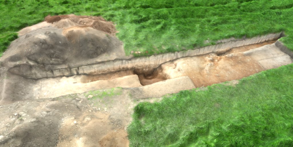
Trowelling in the area around the lip of stones uncovered on Day 22 by John S, show this be a linear feature. What it represents, assuming it’s not natural, is uncertain – could it be an old field boundary or perhaps a stone filled field drain (Patrick found a paper on stone-filled field drains and the image supplied does look similar to this one).
Monday 4th July
Day 25 – Patrick met with Nick the farmer this afternoon with his machine. Trench 5 was extended by about 1.5m. It looks like the extension that had been done by hand, had just reached the outer edge of the ditch. Should be clearer now.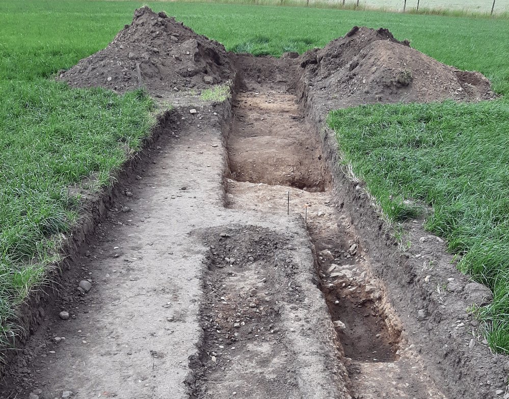 Trench 6 was opened up. Nothing immediately obvious, but the plough soil looks quite deep here. Nick was asked to go down until he hit the top of the clay layer.
Thursday 30th June
Day 24 – Much dryer today for the team of Bill, John S, Andy, Peter and Patrick later in the morning. A bit more troweling in the area previously exposed towards the outside edge, suggested there was perhaps a change of colour. Probing seem to confirm that we may have the ditch in this area and more trowel showed a possible ditch edge but, being of hard clay, wasn’t 100% convincing. If the ditch was in this area we would need to extend the trench outwards which meant moving the spoil. This seemed a daunting task without the help of Nick’s machine but we set to and within an hour or so we had cleared enough to extend the trench by another 1.4m. Removing the topsoil revealed a thick deposit of subsoil, but chasing the hard clay edge proved more convincing that we had located the ditch (this though is well outside the predicted circle but conforms to the ESRI aerial image).
In the meantime Bill and Patrick had another go with the auger in the area between Trench 4 and Trench 2 (there is such a dramatic change between the two, there must be a way of detecting what happens without having to excavate the whole area). There are only two possibilities, either the ditch skirts around the outside of Trench 2 or there is a terminus. Working from Trench 4 where we know where the trench is and where it isn’t our coring seemed to suggest the ditch does not skirt around Trench 2. We looked therefore for a possible terminus on the south side of Trench 2 and eventually found an area where we suspected it to be. It was decided to open our 6th trench here (about 5m south of Trench 2 and pegs were put in for Nick when he becomes available.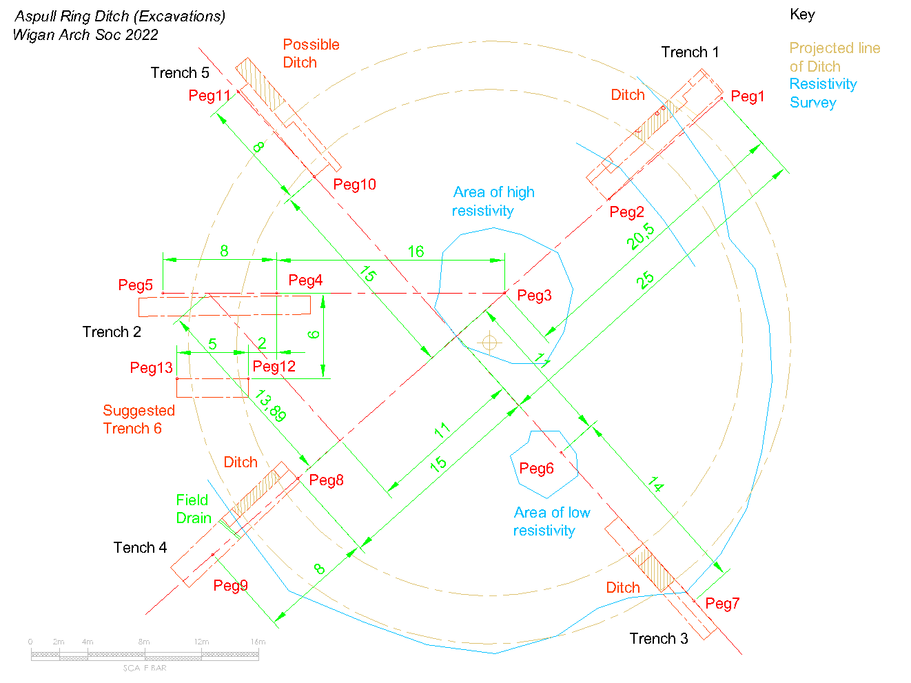
Wednesday 29th June
Day 23 – After a long spell of dry weather, it looks like the rain is back in earnest. Today’s intrepid crew joining Bill and Patrick were Chris, John N and Peter. The strip trench in Trench 5 isn’t really wide enough to be certain what we have so Peter and John were tasked with making it much wider. Bill examined the lip of stones uncovered last week but wasn’t convinced it was the edge of the ditch. He also noticed there was a layer of sub-soil inside the running about a metre from the ‘lip’ towards the centre but not on the other side of it. Once the trench had been widened and trowelled, sub-soil began to appear further outwards from the ‘lip’. It seems there’s a wide 2m band either side of the lip where there isn’t any sub-soil. More trowelling needed before any we can draw any conclusion as to what this means.
The wet weather has certainly improved the look of the ditch in the other trenches, particularly the flag floor in Trench 4. 
The section has also benefitted from the damp, showing up layers in the fill – but a downpour curtailed our session before Bill could get around to recording it (we all got a good soaking before we could pack up the gear and get back to the cars). 
Chris was showing off his new drone (his old one apparently was losing operating it’s range). His latest 3D model of Trench 4 is available here and his overall model of the site here. Recent drone views have shown up, what appears to be evidence of ancient ‘ridge and furrow’ ploughing running north south (how ancient is uncertain).  However looking at the section we recoded in Trench 2, it looks like we may have identified the ‘furrow’ as a dip in the sub-soil.
Thursday 23th June
Day 22 – Today’s work proved to be a bit of a disappointment. Trench 5 did not shown the expected colour change. We may not be deep enough – but it’s starting to look ominously like Trench 2 all over again. John S uncovered a lip of stones about where we expected the edge of the ditch to be, but confusingly there’s another lip of stones about a metre further in. Steve extended the thin strip trench a further three quarters of a metre further towards the centre but this also failed to show anything. 
The coring was also less productive than we expected. The auger went pretty deep everywhere it was tried. There were subtle differences in the feel of the ground as the auger went through, but nothing certain. The best guess is that the terminus must be right up to the edge of Trench 2, and that the ditch may flare out as it approaches it. Obviously more work to be done, possibly opening up a large area between Trenches 2 and 4 chasing the colour change until it disappears.
Wednesday 22th June
Day 21 – Good turn out, joining Bill and Patrick were John S, John N, Chris and Steve (with Martin Trumble late in the afternoon). The day before Patrick had managed to get hold of Nick the farmer and had opened up the Trench 5 using the pegs put in on Monday as a guide. Chris, John N and Bill set about trowelling a half metre strip on the northeast side looking for the tell-tale colour change. By late afternoon the strip was complete but disappointingly no sign of the colour change (maybe we’re still in the subsoil but even the subsoil in Trench 1 had a colour change).
In Trench 4, John S and Steve completed the cleaning of the floor of the ditch, showing it to be 3 metres wide (which is wider than Trench 3 but but similar to Trench 1). Before taking a photo Bill tried wetting the surface of the section but this failed to show up the subtle colour changes which were certainly there (both John and Steve reported on a layer of sticky clay lying on part of the bedrock floor suggesting a pooling of water when the ditch was open).
Trench 4 is only 11 metres from Trench 2 where there was no evidence of a ditch. Some dramatic change must therefore take place somewhere in the space between. It was decided a campaign of coring with the 20mm auger might detect where this might be, so a radial line at 20m meters from the supposed centre was marked out between Trench 4 and Trench 2. Bill tested the technique with a number of cores in areas where we already knew the result, showing a successful outcome was possible.
Monday 20th June
Day 20 – Bill, back from his hols, joined Patrick for an assessment of the progress. The rubble area outside the ditch in Trench 3 is dividing opinion – is it natural or manmade. What appears to be a clean edge has emerged beyond which is most definitely bedrock – maybe too sharp to be manmade and below it there seems to be more rubble. The opinion of a geologist is obviously needed here.
The full width of Trench 4, now fully exposed, shows it to be just over 4 metres wide, which is wider than both Trench 3 and Trench 1. The floor has not yet been fully exposed but appears to be quite flat bedrock. Bill took the opportunity to start recording the section profile of both trenches (it was particularly noticeable that there appeared to be no subsoil outside the ditches of both trenches). 
The lack of a ditch in Trench 2 was still puzzling. A new trench, Trench 5, was therefore marked out diametrally opposite to Trench 3. Pegs were put in along Profile 2 at 15 and 23 metres from Profile 1 (it was noticed while doing this that Peg 6 was slightly out – 30cm in fact closer to Profile 1, Trench 3’s location as remeasured and drawing will be adjusted accordingly).
Wednesday & Thursday 15th & 16th June
Days 18 & 19 – Trench 3 properly cleaned awaiting drawing. Trench 4 – ditch fully excavated and at 1.75m is even deeper than Trench 3 (1.65m). A dark shadow crossing the trench about half a metre outside the of the ditch (noted on Day 14) turned out strangely enough to be a modern plastic field drain (Nick didn’t put it in so must have been his dad).
Wednesday & Thursday 8th & 9th June
Days 16 & 17 – Efforts were split between Trench 3 and Trench 4 this week.
Trench 4: Stirling work done by John and Peter revealed the inner and outer edges of the ditch. John worked on the outer edge and has dug down about a metre below the lip and has not yet reached the ditch bottom. This sondage needs to widen now as it’s getting too cramped to work in. Peter carefully trowelled back at where our best guess was for the inner edge of the ditch and appears to have found it.
Trench 3: Continues to confound. The mass of rubble which is
(apparently) outside the ditch just keeps growing. We’re getting further down and back, and the fill here is loose stone.  So loose you can dig it out with your fingers – it’s full of voids. We’re aware that there is a possibility of finds in this loose fill, so we’re proceeding with all caution.
 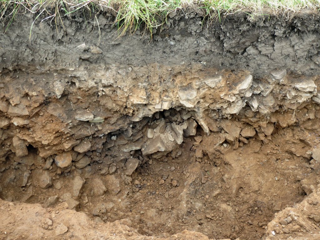 The gap between the rubble fill and the outer ‘ditch wall’ is getting narrower and narrower. Although the stones at the base of the outer ditch wall are lying flat, they may turn out to be loose. The slope of the outer ditch wall may suggest that it’s acting as a retaining wall against the rubble fill beyond. The bedrock beyond the rubble fill is beginning to appear, which may suggest a 6m-wide ditch at this point – confusingly half-filled with sand and half-filled with rubble, perhaps with a retaining wall between them.
 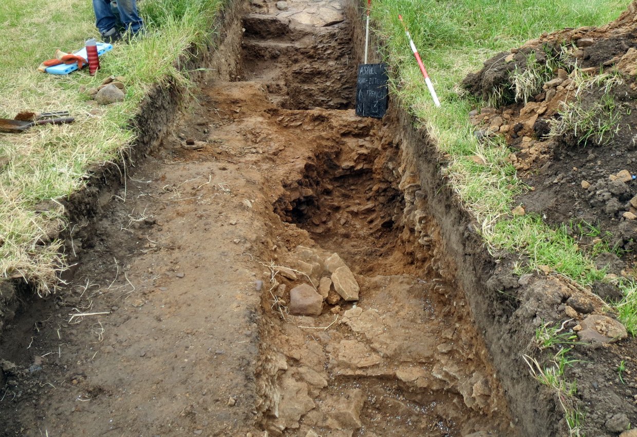 Maybe we have different phases here, but certainly it’s baffling.
Saturday 4th June
Day 15 – Back from his Vindolanda trip, Bill made a short site visit, before flying off again for a week in Greece (assuming no flight cancellations that is) to join Patrick to do some measuring and take some photos. Bill was amazed at the depth of the ditch in Trench 3 which, although not quite as wide as Trench 1, is actually deeper (1.65m as opposed to 1.5m). Despite the recent rain, the site had dried out so, before taking photos, Patrick sprayed the section with water to bring out the colours. 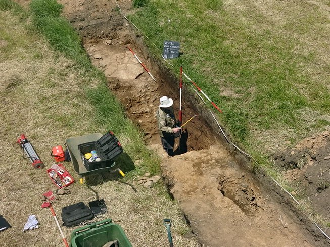 This didn’t reveal much as the section fill looks quite homogeneous, much more than in Trench1, with no obvious recuts. Even a subsoil was difficult to discern, the topsoil seemingly lying on top of the natural.
  About way down the ditch however, a subtle change in colour and texture could be detected, going from a hard brown soil to a softer lighter brown sandy clay. What this represents is unclear but no evidence of layering would suggest only one or two backfilling events.
From the measurements taken of the position of the change in colour in Trench 4, Bill was able to draw circles on the plan representing the possible track of the ditch. This gave an outside diameter of just over 42m (assuming of course it’s perfectly circular.
 A fifth trench on the opposite side of the ring to Trench 3 would confirm the shape i.e. whether it is circular or not.
Thursday 2nd June
Day 14 – Skilful trowelling by John Smalley in Trench 4 has revealed what appears to be the outer edge of the ditch, manifested by an obvious change of colour (a dark line about half a metre before this could be a plough mark).  A small sondage, following the hard surface at this point, seemed to confirm this by revealing the edge of the ditch. This is great news as the diameter of the ring can now be positively established (assuming the ring to be circular – which tends to be the case with Bronze Age barrows).
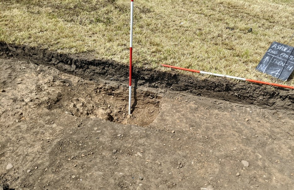 Using his drone Chris was able to complete a contour survey with the hope it might show up a crop mark. Unfortunately it didn’t, but he was able to show the relationship between all the trenches we’ve dug so far, suggesting a OD of between 42m and 43m (assuming it’s circular). The projected line of the ditch seems to go through our Trench 2 which did not reveal a ditch (this is a mystery that we will need to resolve somehow).
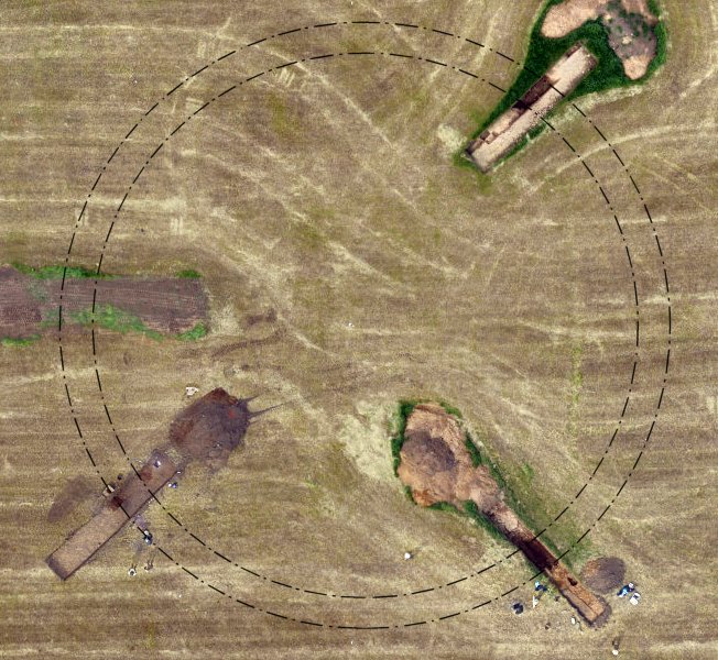 Investigations in Trench 3 in the area of the 2 meter extension revealed a large area of loose rock – it looks like the rock dug out to form the ditch. It’s very wide and very deep – even deeper than the top of the bedrock that the ditch is cut into.
  Theories abound as to what could this represent – secondary ditch – filled in ditch because it was dug in the wrong place – extra-wide main ditch – large pit – etc ., (more investigations needed here).
Wednesday 1st June
Day 13 – A wet day today but Nick the farmer was able to open up Trench 4, guided by the pegs put in by Patrick and Chris. The topsoil appears to be quite shallow here but Nick very skilfully managed to remove just enough to reveal the start of the underlying level. He also backfilled Trench 2 and also extended Trench 3 by another couple of meters on the outside of the ditch.
Monday 30th May
Patrick and Chris on site this morning to mark out Trench 4. Nick had gratefully cut the grass on Sunday which made life much easier. The new trench was marked out where Bill had suggested i.e. on the same alignment as Trench 1 but on the other side of the ring. It was easy enough to do by measuring across from our initial two pegs and a couple of new pegs where put in at 40m and 48m from Peg 1. They were also able marked out a 2m extension to Trench 3, to further investigate the possibility of a bank outside the ditch.
Previously Chris had been out with his drone again and was able to produce a plan and section view (looking NE) in Trench 3.
 This shows a sondage cut into the outside edge of the ditch to investigate the possibility of a bank. This unexpectedly revealed stone rubble which will require further investigation.
He’s also produced a 3D model of this trench which you can access here (it’s a large file so takes a little time to download).
Thursday 26th May
Day 12 – Six diggers today, joining Patrick were Andy, Chris, John, Steve, and new to the dig, Peter Cooke. All the work today was carried out in Trench 3.
Steve, working on the inside of the ditch, got right down to the bedrock (and seems intent on continuing downwards!). We expected to find evidence of the mound here, but there was no sign of any structure at all.
The walls of the ditch have been further revealed and cleaned. Looking very impressive, but the imagined turning of the walls has tended to fade.
The theory of a stone bank outside the ditch still prevails, and that the slope of the outer wall is caused by slumping from this bank (some of the material in front of this wall does look like slump).
Steve, who has now been nicknamed ‘Steamshovel’ has broken three trowels 
(need to have a word with him about trowel use).
Wednesday 25th May
Day 11 – The good news is that on Sunday the grass is being cut. It’s well over knee-depth now and is getting tiring to walk through, especially when wet, which it was (very) this morning.
Trench 1: Patrick deconstructed the pile of stones that lay just inside the ditch. Sadly, there was nothing obvious under it. The clay was a lighter colour than that around it, though, so it may repay further investigation.
Trench 3: In order to investigate the apparent turn (inwards) on the outer wall of the ditch, we’ve cut into the ditch fill in the western side of the trench and moved outwards towards the wall, which still seems to be turning inwards, but the rocks are at an angle that may suggest a slump or collapse.
At the northern end of the trench, where the two holes were found, is an area of large, thick, flat-laid stones, that in another context I might have been tempted to call a pavement.
With the results we’re getting, doubts are creeping in about whether this is a Bronze Age barrow at all, as first speculated, as it does seem to follow the usual pattern. The ditch is far too deep and there appears to be a rock-built bank outside the ditch in Trench 3 (which may have partially slumped into the ditch here).
In Trench 1, a possible clay bank also on the outside of the ditch can be seen. Banks do occasionally appear on the outside of Bronze Age barrows but there is a hint that the monument may have been a henge, at least in its original form. The raised centre may be due to its conversion to a burial at some later date (just speculation of course).
The answer hopefully will come later in the year as Bill has sent off the sample of charcoal from the bottom of Trench 1 for Carbon14 dating. We’ll have to wait though until the end of September however for the result.
Thursday 19th May
Day 10 – Today Patrick was Joined by Chris, Andy and Steve.
The excavated ditch in Trench 3 was extended width-wise to reveal more of the floor and walls. The outer wall continued to slope, with the rock being flat, not angled as would be the the case of slippage.  The inner end of the trench was investigated following the discovery of three or four large stones marking a possible kerb. This end of the trench is very stony, but the thought is probably not a kerb.
  Two interesting circular holes were found, 2 or 3cm in diameter, 50cm apart, looking for all the world like post holes.
  In Trench 1 Patrick started dismantling the large pile of stones just within the inner wall of the ditch. He found it very hard going, and material was coming out at the rate of just one bucket load per hour (this would suggest its part of the natural substrate).
The grass in the field is now knee deep, making walking more of a chore.
Assurance was received from Nick the farmer that it will be cut within the next two weeks.
Wednesday 18th May
Day 9 – With Bill being off on his jollies for the next few weeks (excavating at Vindolanda), Patrick has taken over the reins. Joining him today was Chris, Bob, Andy and Steve.
Digging continued in Trench 3 and the bottom was found being at the same depth as in Trench 1. Also both sides of the ditch were confirmed revealing that this ditch doesn’t appear to be as wide and interestingly, the outer wall of the ditch is sloping, not vertical, whilst the inner wall is vertical, like the walls in Trench 1.
Thursday 5th May
Day 8 – 8 volunteers today, joining Bill and Andy were Chris, John S, John N and Steve with Patrick coming later – and in the afternoon Mark arriving with Ian Miller from the GMAAS.
The two Johns were set trowelling Trench 3 ready for photos. Bill had brought his 15m monopod but forgot his phone which he needed to remotely operate his camera perched on the end of it. He struggled for a while with this camera trying to guess the angle to set it at to get a good result, until Patrick came to the rescue with his camera which did in the end produce a decent photo. In the meantime Chris and Steve were tasked with cleaning Trench 1, having dried out a bit from the previous day, to reveal the bedrock in all its glory. Steve then set about re-wetting the section ready for photos and drawing.
  Andy was asked to set up the dumpy level and bill showed Steve how to take readings. This was to get relative heights across the site – taking a back site from Peg1, then a front site on Peg 5 (Trench 2) and Peg 7 (Trench 3). Readings were 3.23m, 0.26m and 3.26m respectively.
Andy was then tasked with opening a sondage in Trench 2, in the middle where we expected the ditch, just to make sure the hard clay wasn’t overlying it. About 10cm down he hit a very hard stony layer (presumed to be bedrock), confirming there was no ditch there. Andy then checked the rest of the trench with a 20mm auger which showed bedrock at a constant level all across Trench 2.
With Trench 1 cleaned and re-wetted Steve helped Bill with finishing his drawing of the section. They both then set about drawing Trench 2 that despite showing no ditch, had layers to record i.e. below the topsoil and sub-soil there was another layer of soft sandy clay before hitting the hard clay layer. This we presumed to be the remnants of the central mound (although we did get it on the outer end of the trench as well).
When Ian Miller arrived he was very complimentary on our efforts and was amazed at out result in Trench 1. However he couldn’t offer an explanation, however his colleague Ben Dyson at GMAAS my have a better idea as he was more versed in prehistorian matters.
After Ian had gone we set about digging out the dark brown feature in Trench 3 starting at each end of it. Not far below the surface (about a spades depth) the recognisable stone of the bedrock began to appear, the slope on the outside being steeper than the slope on the inside. Gratifyingly this reflects the shape of the ditch in Trench 2.
 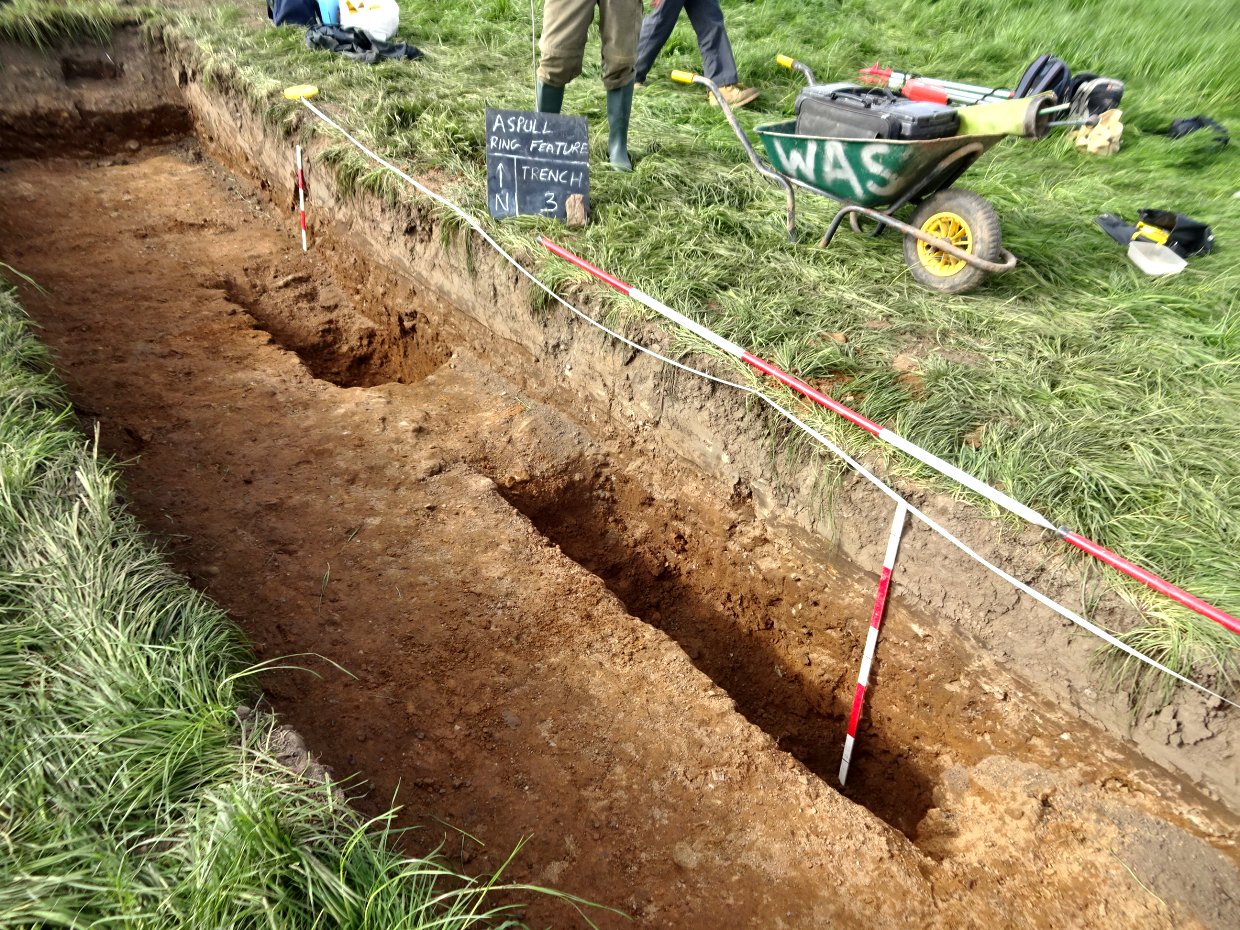 It was now getting late so, after our best efforts at cleaning up what we’d revealed, we left it there for the time being. However it was clear we had another section of the ditch which was a big relief and renewed our confidence in what we believed to be there. To add to this Andy busied himself with an auger (which produces 20mm core holes) on the opposite side to Trench 1 along Profile 1.
 This also seemed to produce a result showing the ditch exist in this area as well. When the three locations for the outer edge of the ditch were plotted a ditch diameter of 43.4m appeared which fits nicely with the geophys result and to a certain extent with the ESRI aerial photo (but not so much with the Google aerial for some reason).
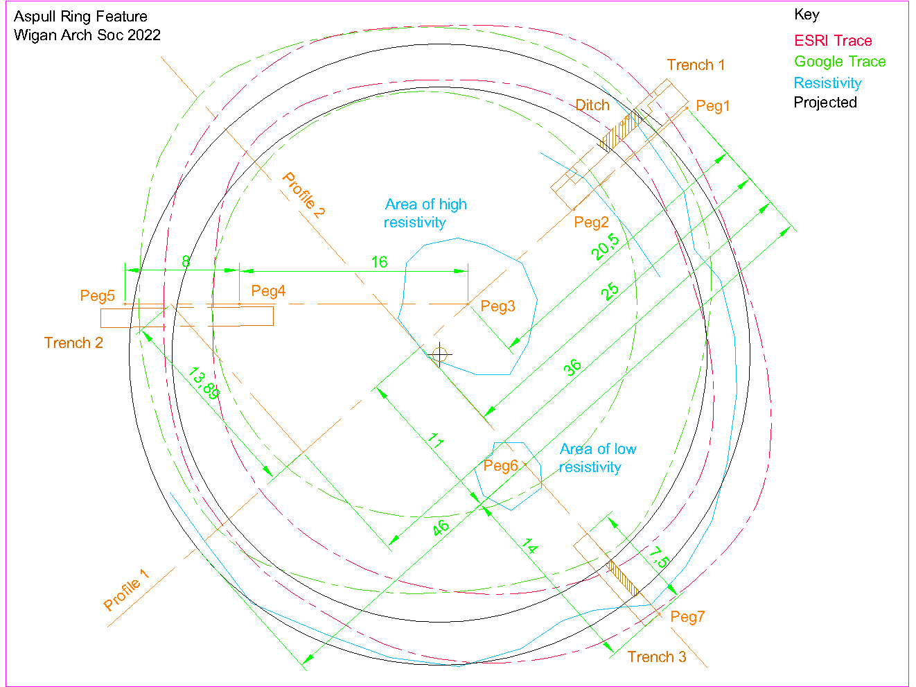
Wednesday 4th May
Day 7 – Despite the rain we had a decent turnout with 6 on site, i.e. Bill, John S, Chris, Bob and new starter Steve Taylor (and Patrick when the rain eased). At least the wet weather had brought out the colours in the ditch section.
Chris and John were tasked with removing the step we’d left in the ditch for access on the NE side, so that the full section could be drawn. This left us relying on the step in the opposite corner which proved a little unreliable. When the removing the step Chris found more charcoal to take a sample of.
The previous day Patrick and Bill had marked out Trench 3 on a line perpendicular to Profile 1 and 25m along it from out first peg (Peg1). When Nick (the farmer) arrived with his machine, we directed him to the starting point which was 25m from Profile 1. Working inwards, he opened our new trench to about 5m down long, down to the subsoil but there was no obvious colour change. We therefore asked him to take it down another 10cm through the subsoil. This produced a light orangie brown soft sandy clay (with stones) changing to a darker brown about 2m in. Was this our ditch? – probing with a steel rod suggested it was. We therefore asked Nick to expand the trench another 2.5m which produced more of the light orangie brown clay about 3m from the edge of the first colour change. We spent the rest of the day cleaning and squaring up the trench so that we could photograph this potentially exciting new find (it was great news after the disappointment of Trench 2).
While we busied ourselves doing that, Chris droned the site and later produced two 3D images which he presented at the Society meeting later that evening.
Low res model showing all 3 trenches:
https://www.mapsmadeeasy.com/maps/public_3D/3c4a677b241741b79d0139c6bcea73cb/
Low res model of Trench 1:
https://www.mapsmadeeasy.com/maps/public_3D/a87ccd48c4e44124a079e1fd021e18de/
Saturday 23rd April
Day 6 – Another good turnout at the weekend with 7 on site – joining Bill were Andy, Bob, Paris, Conor, Ken and Patrick.

Archaeologist’s commute
Paris and Bob were tasked with trowelling and squaring up the SW end of the trench while Conor and Ken continued to dig the the loose out of the ditch – Conor working on the SW side while Ken concentrated on the bottom of the ditch. When all the loose was removed, the bedrock at the bottom was revealed showing it to be quite flat. When Patrick arrived he took over from Conor cleaning the SW edge of the ditch which was proving difficult as a lot of loose stone was coming out. It was difficult to determine whether this was a crumbling bedrock or backfill in the ditch. When cleaned of the loose clay, it did look like the former but this can only be confirmed by removing it to see what’s underneath.  When the ditch was finally cleaned up (leaving a step on the NE side for access) the full extent of the feature could be seen – and it was quite astonishing. A ditch cut through hard clay and bedrock over 3m wide and 1.5m deep using just the tools available at the time represents a huge amount of effort.
When Nick the farmer arrived with his digger, he was directed to the area we had marked out on Thursday. Starting on the inside of the feature he soon had the topsoil off but there was no evidence of a colour change in the subsoil. We therefore asked him to remove the sub-soil to see if we could identify the natural we had seen in Trench 1. This came up just another 15cm or so below the subsoil but no sign of a ditch even when tested with a steel probe. It was decided to extend the trench by 2m on the east side in case we had made an error with our measurements but still no ditch visible in the natural.  Looking at the section however, there appeared to be a bright coloured layer lying under the brown subsoil. When Andy was tasked with squaring up and clean the section at this end of the trench, the depth of this material was revealed to be quite deep and probably represents the start of internal mound.
 Paris and Conor were tasked with cleaning the section of the trench on the west side. This revealed that the bright coloured layer giving way to a deeper darker brown layer, which may have something to do with the crop mark images we saw on the aerial photos. After we left for the day, Nick extended the trench on the west side by another 2m but reported that there was still no obvious sign of a ditch.
This is certainly a setback and we will now need to look at opening up a third trench, Trench 3 on the southeast site where the resistivity was more positive. Hopefully this will re-establish the ditch and confirm that it really does form a circle as indicated on the aerial photos.
Thursday 21st April
Day 5 – Just 5 today, Chris, Bob, Andy, Bill and Patrick.
Andy was tasked with cleaning and squaring up Sondage 4 while Bob extended Sondage 3 all the way to the end of the trench.
Chris was tasked with chasing down the hard clay on the SW side of the ditch to see if he could confirm the inner edge of the ditch (first identified by Paris on Saturday). To do this he removed the loose stone layer he had previously discovered. His work revealed that this was the inner edge of the ring ditch feature and, as with the outer edge, the side was almost vertical.
In the meantime Bill concentrated on digging out the ditch on the NE side. This revealed more of the bedrock in the wall of the ditch and at the bottom of the ditch, a lot of loose flat stones embedded in light yellowie brown soft clay (the clay was sticky and quite wet).
When Patrick arrived, he took over from Bob extending Sondage 3 and cleaning it out. To convince ourselves that the hard pinkish clay was natural, Andy was tasked with taking Sondage 4 down further. Again this proved to be very difficult and Andy was soon convinced that this layer was the natural.
In the afternoon, Nick the famer together with his wife and daughter, came to visit. We discussed using his machine to do some of the digging. It was decided not to use it in Trench 1 as enough had been already dug out by hand to understand its structure. We therefore talked about another trench, Trench 2, on the other side of the ring feature so that it’s diameter could be determined, Bill said he had already identified a couple of spots, not necessarily diametrically opposite Trench 1 as this might not cross the centre of the feature, but at two locations roughly equally spaced around the circle. The site selected for Trench 2 was for a 8m by 1.5m trench on the west side of the feature in an area where the two crop mark images from the aerial photos coincided (the resistivity in this area though was particularly vague). A third trench, Trench 3, was located on the southeast side of the ring feature so that an accurate value for the diameter of the ring can be obtained. This one may have to be 14m long due to the variations in the crop mark images but it would take in an area of low resistivity shown on the resistivity survey. 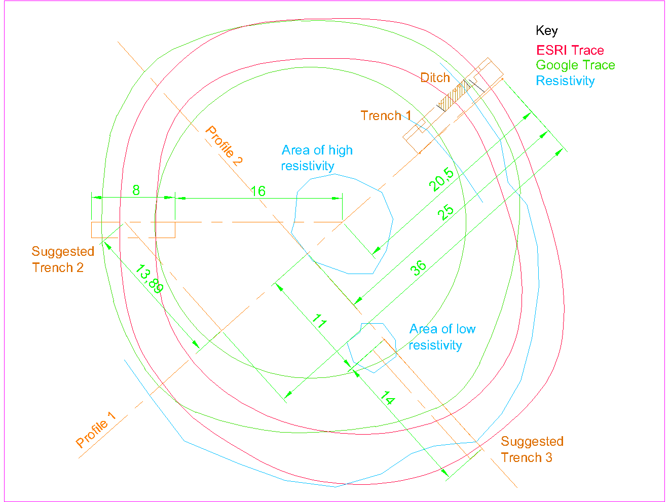 Andy, Bill and Bob finished the day by marking out the site of Trench 2 ready for Nick to dig with his machine which he said he could do next time we’re out.
Wednesday 20th April
Day 4 – 6 attendees today, Chris, John N, John S, Bob, Bill & Patrick.
Bob was set to cleaning up the SW end of the trench (i.e. Sondage 3) and then widening it to 1m. The rest of the team were tasked with removing the baulk in the ditch area to enable Sondages 2 and 3 to be joined up. Before this however Bill recorded the position of the 3 presumed postholes and a sample of the charcoal taken from the third one. As the baulk was removed it became clear that the so called postholes were in fact one single layer of brown stained sandy clay, containing with flecks of charcoal. This perhaps represents a burning event when the ditch was still open but partially filled. As the fill was taken out of the ditch in the Sondage 2 area the outer bank of the ditch began to be exposed. It consisted of the hard pinkish clay lying on top of stone bedrock. Further down in the trench another brown stain appeared representing an earlier phase in life of the ditch.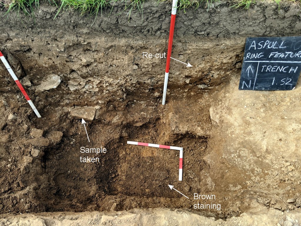
On the other side in the Sondage 3 area, a layer of loose of stones began to immerged, perhaps as a result of a slighting of the central mound. It lay on top of more soft clay fill so certainly not part of the bedrock.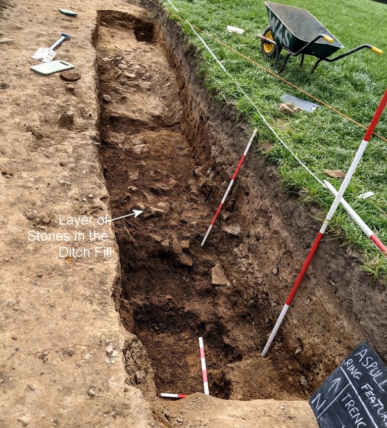
Finally Bob was tasked with opening up a new sondage, Sondage 4, located well inside the ring feature to investigate the stratigraphy in the this area. Bob needed the mini mattock to cut through the hard pinkish clay which lay under the sub-soil (indicated by the blue line). The clay was very similar to the clay in the Sondage 1 but some doubt was cast on it being natural as black flecks appeared in it which were thought to be charcoal. On closer examination however, these turned out to be small pieces of shale therefore quite likely to be natural.
Saturday 16th April
Day 3 – big turnout today with 10 on site in total. With the usual 4 i.e. Andy, Chris, John S and Bill, we were joined by newcomers Paris Welsh, Conor Grant and Bob Sanders (Patrick, Jim Meehan and Mark Tildesley joined us later).
It was Bob’s first time but he showed great enthusiasm trowelling out Sondage 1 to reveal in some detail a compacted stone surface (in other circumstances this could have been a nice section of Roman road but there was nothing to suggest this was manmade).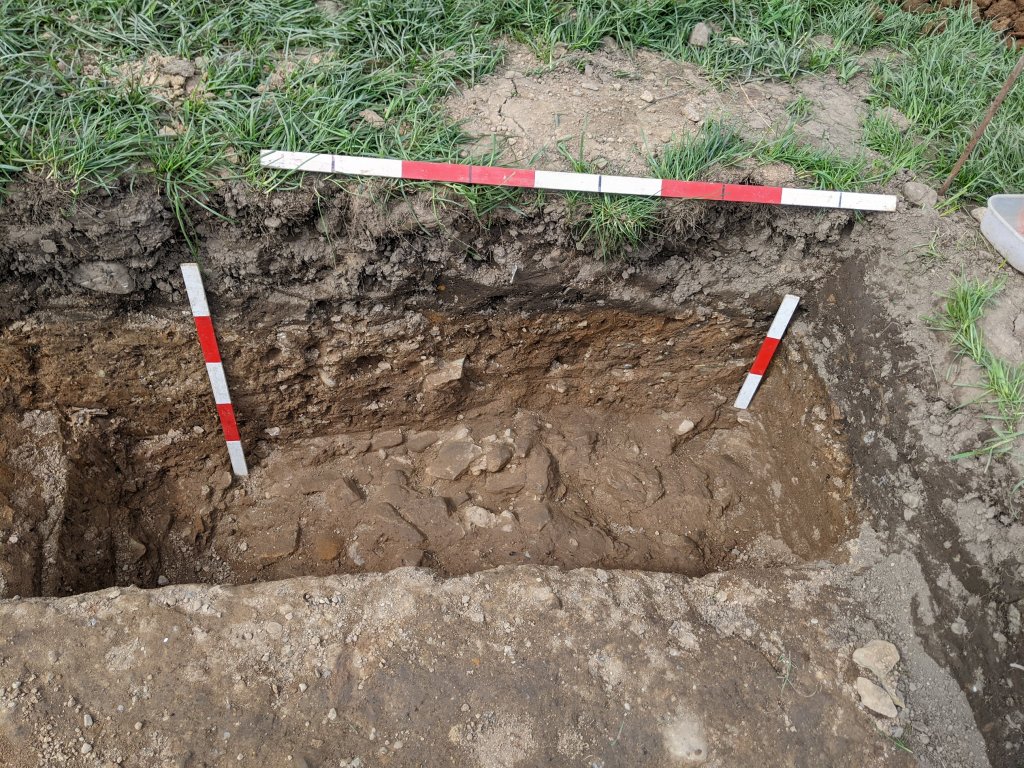 Chris and John were tasked with chasing the profile of the cut in Sondage 2 which seemed to get steeper and steeper. At a depth of about a metre a large stone appeared which had black material around it, presumably charcoal. Removing the stone revealed a brown stain with flecks of the charcoal in it suggesting perhaps a post hole. It was decided to take a sample of this black material for later analysis.
  Paris was tasked with trowel the surface of Sondage 3 and when Patrick arrived the sondage was expanded towards the NE. Pretty soon a stony surface was revealed but it was unclear what this represented – was it a result of a slump of the mound or a deliberately placed kerb around the mound (could even be natural but didn’t feel like it as the stones were loose). As Paris trowelled down towards the centre of the trench a distinctive edge began to appear perhaps indicating the inner edge of the ditch. Further in a darker brown stain began to appear and, as with the stain in Sondage 2, it contained flecks of what appeared to be charcoal (we assumed this was another post hole).
  When Jim Meehan arrived, Andy showed him how to set up the dumpy level and Mark came, the three were set with the task of surveying the profile of the mound. Using Chris’s 100m tape, readings were taken every 2m from the outside peg towards the centre of the mound for a distance of 60m. This done, a second 60m scan was taken a 90 degrees to the first at 25m along the first scan line (Jim took the readings in his note book).
Finally it was decided to expand Sondage 2 towards the centre of the trench (new recruit Conor provided the muscle for the task). In the bottom corner another brown stain appeared, again associated with a stone and flecks of charcoal under it (it was assumed to be yet another post hole).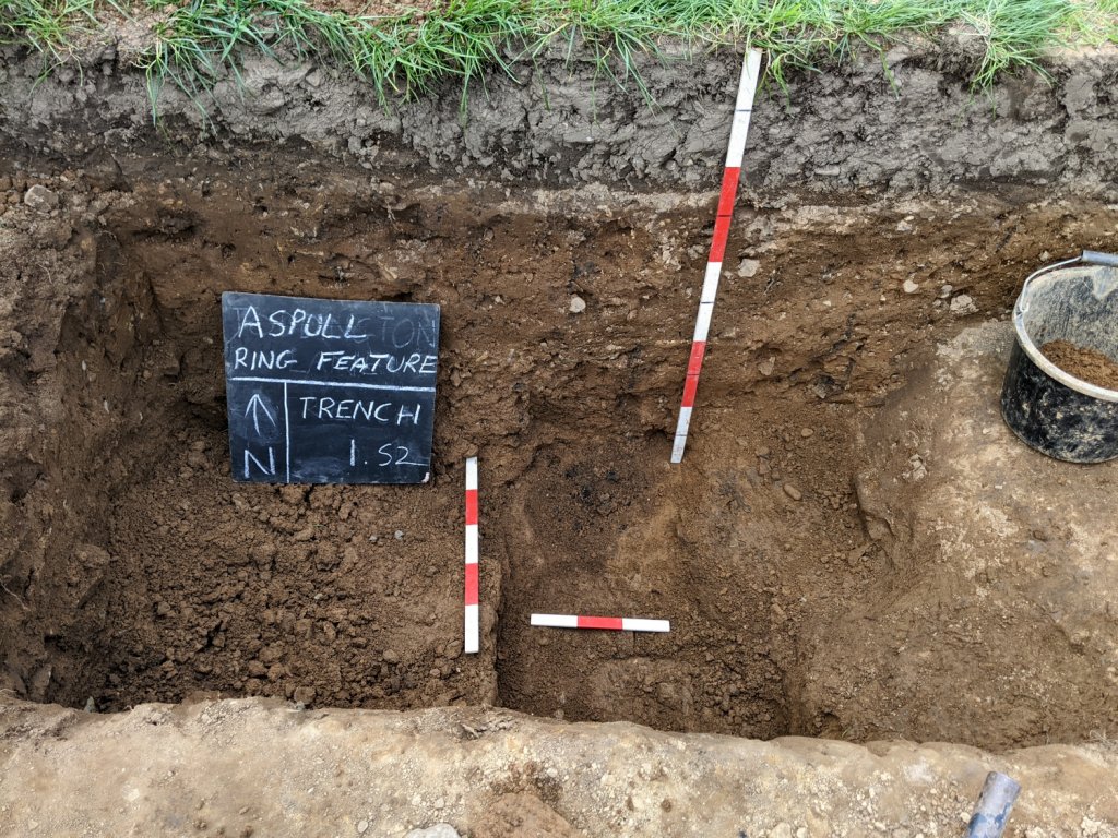
Before we packed up for the day Chris flew over with his drone and later that evening sent an amazing 3D model of the site, which can be view here.
Thursday 14th April
Day 2 – just 5 of us today, Andy, Chris, John and Bill (with Patrick joining us later).
Chris brought his drone to get a plan of the site.
John was initially tasked with expanding Sondage 1 and then join it up with Sondage 2 following the surface of the compacted clay. This revealed that the sub-soil sandwiched between the plough soil and the compacted clay was uneven (there was even a suggestion that the clay represents a bank outside of the ditch – although the clay layer did not seem to be a manmade deposit).  Andy was tasked with opening up another sondage a few metres further towards the SW to see if we could pick up the inner edge of the ditch. There was nothing to indicate where this was on the surface and trowelling down through the sub-soil to reveal any indication of an edge – in fact the sub-soil just kept on going.
 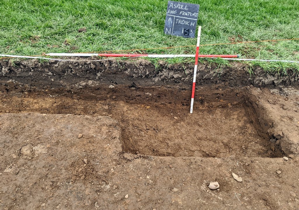 In the meantime Bill busied himself with setting up a string line so that the section could be drawn. To get the string level he used the dumpy (but this only confirmed that an early attempt by Andy with his line level was correct).
Having finished with drone, Chris started to expand Sondage 2. This was to explore the profile of the newly discovered ditch. Following the compacted clay, Chris was able to show that the cut was quite steep and when the section was clean a re-cut was revealed (showing that there was at least one multiple phase to the feature.
The day ended a little early due to an unfortunate incident when the gate to the next field was left open. This allowed half a dozen excited horse into our field and a farcical attempt by us to try to them round up and get them back into the other field. When this failed we had the embarrassment of having to ask the stable girls to do it for us.
Wednesday 13th April
Day 1 – start of the excavation proper. 7 attendees altogether, Ken Scally, Chris Drabble, John Smalley, John Needles, Andy Wilcock and Bill (Patrick arrived later in the morning).
All joined in with the trowelling and soon a distinct change of colour began to appear in the NE end of the trench.  Further trowelling revealed the exact change point represented by a line across the trench about 3m from the NE end where the colour changed from a light orangie brown to a dark orangie brown (as previously detected in the test pits).
  The only other feature to be detected was a series of dark parallel lines running W to E which were probably the result of deep ploughing.
  It was decided to put in two sondages (a sondage is a small trench to help clarify stratigraphic sequences but carrying out the main excavation). The first was in the N corner of the NE end which deemed to be outside the ditch. This was to establish the nature of the subsoil in this area. This turned out to be a thick layer of firm pinkish coloured clay lying on top of a surface of compacted stones both of which we assumed to be the natural substrate.
  The second sondage was positioned on the line of the colour change on the NW side of the trench to see what was causing the colour change. The thick layer of pinkish layer of pinkish clay again appeared in the section but this time it dipped down towards the SW. This seemed to represent a cut in the clay, filled with dark brown sandy clay (the cut is marked with a blue line in the photo as it doesn’t show up well in the photo).
This was quite exciting as it’s our first clear evidence of the ditch we are looking for.
Monday 11th April
On site (Bill, Patrick and Chris Drabble) – met with the famer to watch him remove the topsoil after having marked out the 2.2m x 11m trench. This was done skilfully and just enough to show signs of the subsoil coming through (it didn’t take more than half an hour).
Thursday 24th March
Today we made a short site visit (Bill, Andy and Patrick) to mark out the suggested Phase 1 Trench location. Two Pegs were installed at the corners of the SE side of the Trench and two test pits were dug no bigger than 30cm x 30cm to see how deep the topsoil was at each location.  This turned out to be between 25and 28cm. The change in colouration of the sub-soil was also very encouraging as the sample from the internal position was much darker.
Later we spoke to Nick the farmer about the possibility of using a machine to remove the topsoil.