
Date: Tuesday 5th June
With the GM Federation Archaeological Festival drawing close (22nd/23rd June) we decided to leave Trench 1 (Site 2) for the time being and open up some test pits on the Road road site ensure we have some archaeology for the volunteers to work on. Just three of us today (Me, Andy and Trevor) – that is until Mark turned up with his camera (which was handy as I’d forgotten mine) . Using the baseline that we had established on our last visit, Andy quickly located the position for our first test pit, which was intended to be over the linear anomaly detected on the 2016 GPR survey on on the east edge of the road. Well that was the plan (more on that later). After removing the turf from a 1m x 1m test pit, we soon reached the light brown subsoil, but no sign of the anomaly. Extending the trench another half metre to the south, thankfully the reason for the anomaly was revealed and it was as we suspected a field drain, i.e. a narrow ditch feature.
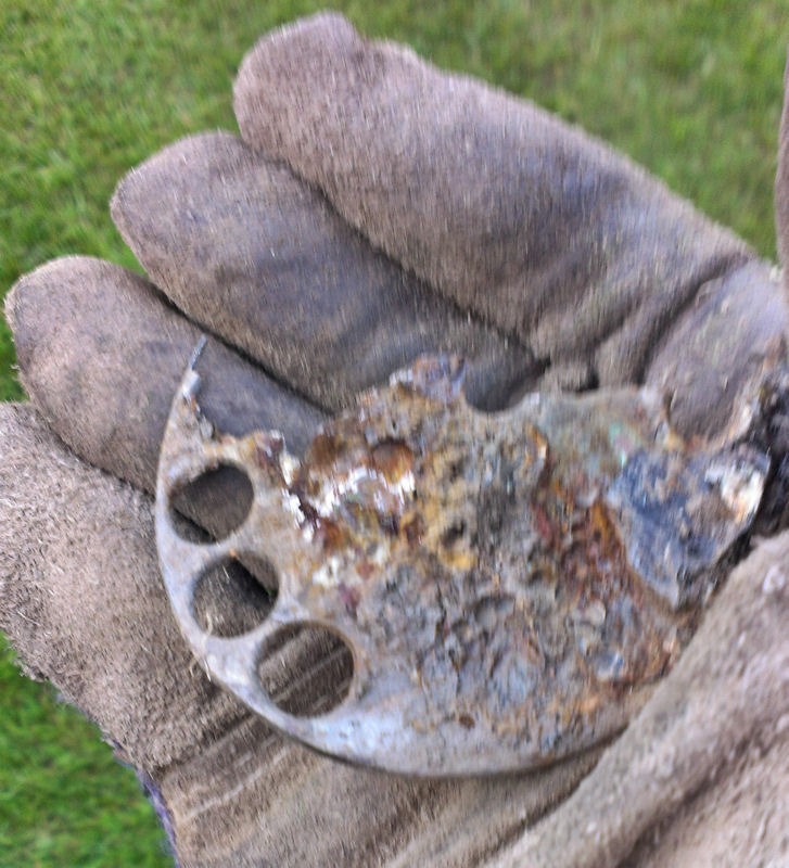
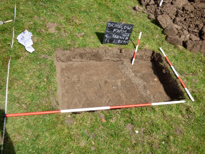 It was filled with material which had experienced burning including vitrified lumps and the date for the fill quickly became a apparent when a fragment of a telephone dialer came out of it.
 Having established the linear feature, we needed to find out the reason for the apparent 90 degree bend in it as shown on the GPR survey. Our next 1m x 1m test pit was located 3.5m west of the first but again we had to extend it by half a metre (this time northwards) before we could detect the feature. However instead of a bend, the feature continued across the trench even after another half metre extension (obviously something wasn’t quite right as it wasn’t matching our survey).
 Before we finished for the day one nagging question remained – could we still find the Roman road? (if not, it would not only put doubt on our previous findings, including the GPR result but also whether there is enough archaeology on this site for the GM Festival in 2 weeks time).We therefore put in a small (1m x 0.5m) sondage on the south side of test pit2 and thankfully stone cobbles began to appear just a few centimeters into the subsoil.
 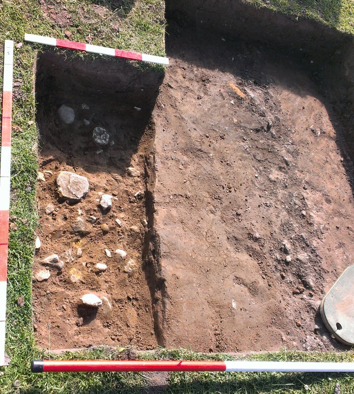 Once back home I soon realised why we weren’t finding the linear anomaly where we had expected it be and why we hadn’t been able to detect the bend in it – we weren’t actually where we thought we where. In fact we were further east by about 3m (I can’t blame Andy, he was working off the dodgy scale on the drawing and I should have pre-marked it anyway).
  However it does show that we have been able to replicate our position quite accurately from our 2016 survey work.
Date: Friday 8th June
Just me and Andy today (everybody else seems to be poorly for one reason or another). Anyway we took the opportunity extend the the sondage we had opened on Tuesday to see if we could find the eastern edge of the road. Nervously we cut through the subsoil under the turf (finding good evidence for the road here was essential for a good number or reasons). We needn’t have worried however, as the telltale cobbling began to appear in some quantity, albeit at an ever increasing depth. they extended beyond our 1 metre extension. In the end we needed to extend the trench by a further 2.5 metres before we were sure we had found the edge of the road (at about 1.5 metres beyond the first sondage). The cobbles here demonstrate a significant camber here (similar ti Stanifield) and end quite abruptly which gives us a definite edge of the road. If our measurements are correct, this could show that the width of the road here was 10 metres (similar again to Stanified). No ditch though – instead there seams to be a line of stones which was also detected last time we were here in 2004. Could it be that this was how they marked the position of the road instead of the usual ditch. A trench on the other side of the road will hopefully confirm the width.
Date : Tuesday 12th June
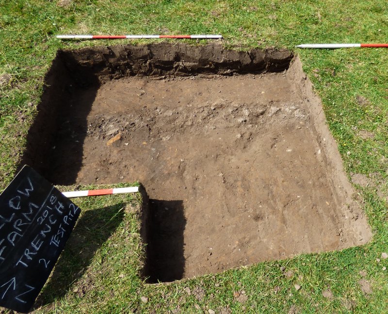
Four on site today, me and Andy starting in the morning as usual, with Trevor paying a visit in the afternoon followed later by Mark with his metal detector. The quest today was to find the end of the linear anomaly where it appears to turn through 90 degrees, so another test pit (No.3 ) was put in half a meter to the west of test pit 2. The anomaly appeared quite readily at the bottom of the trench but we had to extend it by another metre westward before the end of it could be seen. As predicted, it did have a 90 degree bend but this stopped after just a few centimetres. After some head scratching we decided to extend the trench northwards by half metre but no sign of the 90 degree anomaly. We therefore decided to take the extension down to the level of the Roman road which reassuringly appeared just a few centimetres below the level of the anomaly. 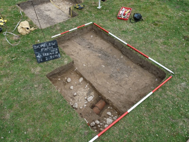 Amongst the stones of the Roman road the anomaly appeared but this time with just a clay fill instead of the burnt material we’d seen before. Not far into the fill, the reason for the anomaly suddenly became apparent as sections of a terracotta drain began to appear. The fill is so different and, as there seems no be no indication in the sub-soil, there is a suspicion that the two anomalies may not be related (a conundrum to be solved at a later date).
Date: Wednesday 13th June
It’s was a late start today as Steve Baldwin had asked me to pay him a visit at Burscough to talk about a possible collaboration with an interesting project he is currently working on. It was still worth going down to Brimelow though, as the Patrick had promised made an appearance, joining myself and Andy for the afternoon session. Patrick as not been well since the start of this project so, although clearer still not properly fit and well, it was great to see him in the field, . The plan today was to investigate the western edge of the road to see if we could confirm the width of the road (now assumed to be 10m) and also see if we could locate the ditch feature see in the 2004 excavation. Finding the end of the linear anomaly on our last visit, enabled me to more accurately fix the position of the GPR survey which indicated it needed shifting 0.5m to the left. This in fact makes it a better fit with our expectations of the extent of the Roman road itself. With this in mind we placed our next test pit (No.4) 3.5m west of test pit 3. 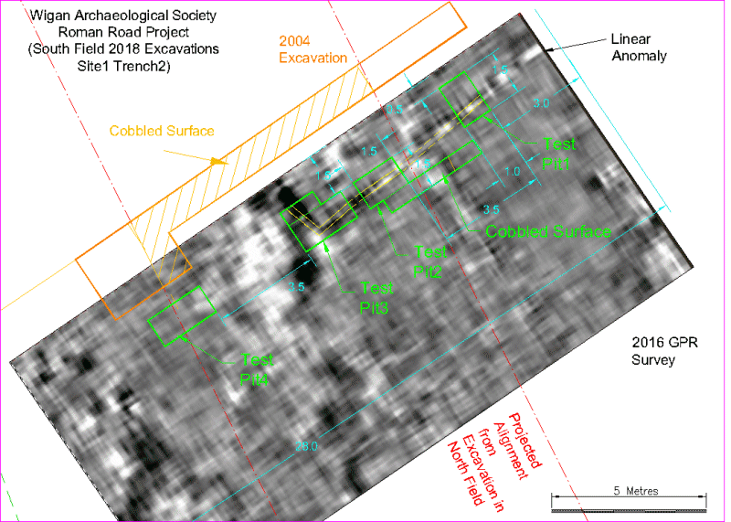 Just about got down to the Roman road level when we ran out of time. The sparse amount of stones appearing however suggested, however, we may have overestimated its width and may need to extend the trench half a metre back towards test pit 3.
Date: Tuesday 19th June
Need to get the site ready for the GM Festival of Archaeology at the weekend, so me Andy and Mark set off with extending test pit 4 by half a metre on the east side (as suggest from last weeks visit). Sure enough a good section of metalled surface was exposed. This enabled us to chase it westward til we found the edge. Surprisingly it did continue as far was our original prediction – at least, that is, on the north side of the trench. On the south side, a gap seemed to open up devoid of stones suggesting that perhaps the road has been destroyed in this area.
Date: Friday 22nd June
For this the first day of the GM Festival of Archaeology we hadn’t had a great response from volunteers. I therefore thought perhaps to start late – and mentioned it to Andy but then forgot to tell him I’d changed my mind when volunteers did make contact. Anyway Trevor was there early and soon volunteers (Dave North, Tony Boylan and Dave Flanagan) arrived. Trevor, who wasn’t fit after laying flags in his garden all week, contented himself with manning the gate, shepherding unsuspecting passersby onto our site. We soon had a stream of curious locals, keen to see what we had been up to and then fascinated with what we had found (i.e. an unexpected Roman road on their doorstep).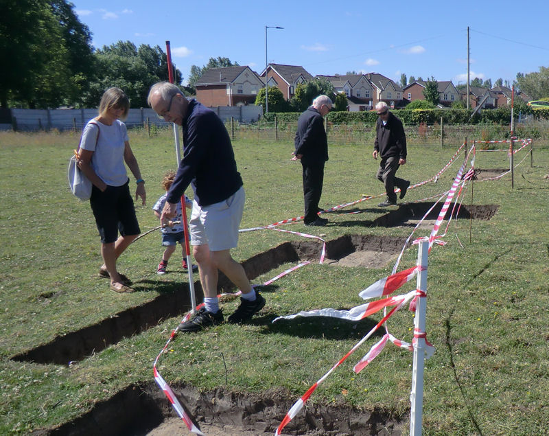 Between showing people around the site, we needed to set our volunteers with tasks for the day. Having exposed the road on each side, it was time to put a section through them to try to understand the road’s construction (and see if ditches could be identified). Ideally the sections should be perpendicular to the road, so a line was measured in using our drawing as reference. While Dave N and Andy started on the section in test pit 4, Tony and Dave F looked at expanding test pit 2 southwards to give them some room to put a section in on that side. In the afternoon we were joined by Patrick and Mark. As usual Mark brought his metal detector and there was an air of excitement when a response deep in the test pit 4 was detected – only to be disappointed as the signal disappeared when we tried to dig it out (seems it may have been the rusted the remains of some ephemeral object with an iron content). By the end of the day we had a section in test pit 4 but no sign of a layer underlying the cobbles or anything like a ditch (we obviously need a deeper trench – something for the next set of volunteers).
Date: Saturday 23rd June
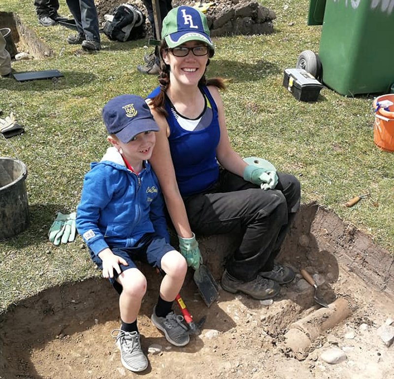
For this day we were oversubscribed but as two of the volunteers were children, it wasn’t a problem. With Trevor on the gate again, we also had a good number of visitors curious to see what was going on. When our full contingent of volunteers (Alex Flahive, Tracey Mckeown and daughter Lily, Vanessa and son Lucas, Darren and friend Al Eastham) we soon set about explaining the site and allotting tasks. Test pit 4 obviously needed to be wider so Alex, Darren and Al were given the job of extending this trench half a metre southwards.

Alex and Al
Vanessa and Lucas were tasked with investigating the strange field drain junction in test pit 3,
Vanessa and Lucas
while Tracey and Lily, joined later by Al, were asked of taking the newly extended test pit 2 down to the road level. Our farmer, Roy Brandon is currently working away but his partner, Chon, has been showing great interest in our activities and has kept us amply supplied with copious amounts of strawberries from her adjacent allotment. Also Darren brought his kettle and cooker so there was tea and bacon butties for anybody that wanted them.
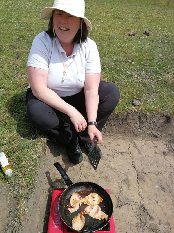
Tracey ‘Rozza’ cooking up lunch
By the end of the day, more of the road surface had been uncovered in test pit 2 and the mystery of the field drain trench had been solved (well partly). Inverted ‘U’ shaped pots were found in both legs lying on a bed of flat stones.  They joined up at the junction so obviously from the same phase with an age range between late 19th to early 20th century but still no idea why the 90 degree turn.
In test pit 4 we managed to excavate a deeper section through the western edge of the road but with little result. The yellowy brown clay that the stones of the road are embedded in seemed to continue beyond the road and rising slightly. As we cut through this the underlying layer seemed to be redder and grittier suggesting a natural ground level.  However, due to the very dry conditions, it wasn’t easy to see if this was any different than the yellowy brown layer above it – wetting the section suggested it wasn’t. If this is the natural, it would suggest that the original surface was levelled prior to road construction. However, if we are still in road construction material then our trench will need to go deeper (something for next time).
All in all it was a very successful weekend with all the volunteers expressing how much they enjoyed it (hopefully new members in the making).
Date: Wednesday 4th July
Most of the day was spent working back at our other site (Site 2) but now that our excavations have dried out, it was worth a look to see what the section looked like. In test pit 4 in particular, both the section under the road surface and the section under the sub-soil on the west side now look to be the same (ignore the darker patch on the bottom of the trench – this is the start of a deeper cut). As suggested before, if this is the natural then it would indicate the land originally sloped downwards from west to east and the Romans levelled the ground with a terrace before the road surface was laid.
On the far west side (righ in the photo below) a slight depression could be detected in the sub-soil suggesting a shallow ditch (similar to the one detect in the 2004 excavations). On the south section of the trench this was much more prominent (see below). Could this be the roadside ditch? It is actually higher than the road itself but there is a general consensus that these ditches were for marking out the road prior to construction, rather than for drainage purposes.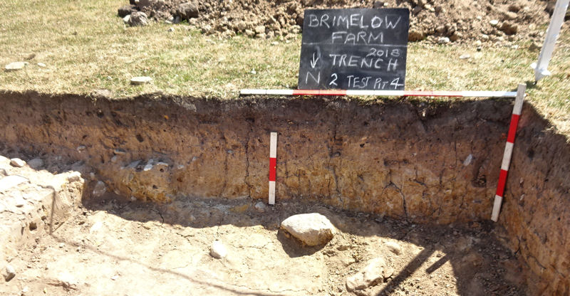
This trench obviously needs extending westwards to explore this theory further (something for next time).
Date: Wednesday 11th July
Still the weather continues to be hot and the ground is baked hard. However we have to make progress so our team today (myself, Andy, Mike Keulemans and new member John Ashcroft) set to work extending test pit 4 half a metre westwards to explore the possibility of a roadside ditch cut into the natural (although higher than the road itself, this could be a marking out ditch rather than for drainage as is generally thought). After much effort through the hard clay, a section was produced but instead of revealing a ditch, the cut in the sub-soil seemed to go deeper. This suggests either a large depression rather than a ditch or a localised ridge of natural clay.
While Andy cleaned up the section Mike busied himself cleaning up the test pit 2 where the eastern edge of the road had been exposed. This is in preparation for a section to be put through to see if the original surface could be detected (the natural seems to be higher on the west side than the east and as the original surface could not be detected on the west side, there is a suggestion that maybe the construction surface had to be prepared with a slight terrace to make the road lever).
It was difficult for Mike as the dry conditions made it difficult to distinguish between the road edge made of stones mixed with clay and the grey silt lying off the road (hopefully some rain might help when we make our next visit).
John was tasked with revealing the field drain in test pit 1. This was so that we could discover the direction of drainage by leveling it with the section uncovered in test pit 3 (the direction is not obvious looking at the field as there is a drainage ditch running down the west side of the site).
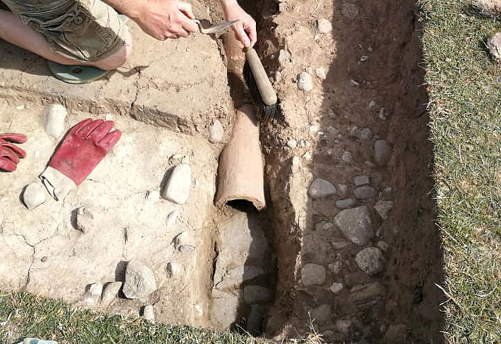
Field drain in test pit 3
Once revealed, our leveling using the dumpy level, showed the drainage ran west to east which was slightly surprising as the ground rises towards the centre of the field. However there is a slight dip before the rise so maybe there is another drain which this connects to running down through this dip.
The inverted ‘U’ shape of this field drain is intriguing. There are as can be expected been studies on the history of field drains and this shape seems to date from the early 19th century (mid 19th century drains had the word ‘drain’ stamped on them as a tax exemption can into force at that time. After that time, a machine for extruding pipes had been invented. Our drains are crudely made suggesting an early date but the fill from our trench suggests a much more recent construction (maybe even post war as apparently an agricultural depression up to the 1930’s meant very little drainage to place). Could it be that the farmer has reused, relayed or just cleared the original drains.
John and I also took the opportunity to level the road itself which did show a slight slope downwards from west to east (which supports the theory about the silt being the wash from the road).
Date: Wednesday 18th July
Just John and I today with Mark joining us in the afternoon. However we did manage to get quite a lot done. First job was to fully excavate the field drain in test pit 3. This was so to see if we could get a firm date for its construction and also obtain a section through the road in the central area. The pottery coming from the back-fill varies widely but a piece of plastic insulation from electrical wiring confirmed our suspicion of a very recent date (as previously mentioned). Also John’s section, after fully excavating the cut for the drain, showed the depth of road here to be quite shallow.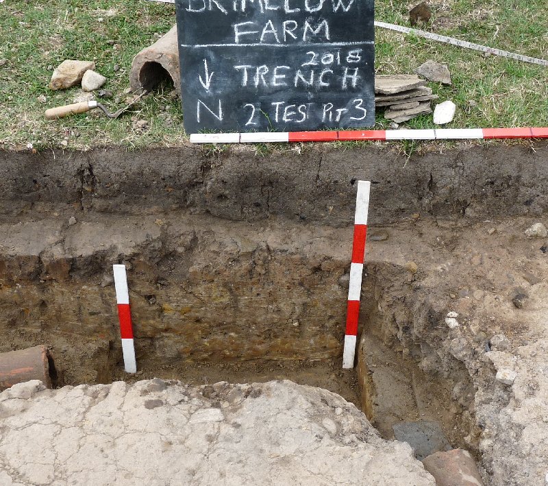 i.e. under a 15/20cm depth of plough soil, a thin layer (no more than 8cm) of sub-soil overlies a 12cm band of clay which has the cobble stones of the road embedded into. Underneath that is the natural, a reddish clay which turns yellow when dried out.
While John then turned his attentions to excavating a section through the eastern edge of the road in test pit 2, I had another go at cleaning the section on the western edge in test pit 4 to see if we could understand the roads construction. What this revealed on the western edge was a shallow ‘vee’ shaped dip (I won’t say ditch) in the natural near the road’s edge which seems to suggest the start of a camber (there are many cobbles in the natural which seems to undermine our assumption that it is the natural). 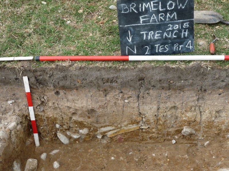 Meanwhile in test pit 2, John with the help of Mark, did a great job digging a section in the through the road’s eastern edge. This revealed a similar story to the result form our 2004 excavation i.e. a layer of grey silt extending beyond the edge of the road (show on the right in the photo below). It appears to lie under an interface layer between it and the sub-soil. As with the 2004 excavation, there is an outlying large stone – was this used a road marker instead of the usual ditch?
With the rain earlier in the week the thought was that perhaps a resistivity survey on the higher ground in the centre of the field might show something. Both Bob Hayes and Trevor had suggested there could be something in this raised area, one, because of its elevated position and two, because of the lush vegetation despite the recent drought conditions (Trevor also thought he could see a circular feature in the wed growth). Think this may be our only chance and with time to spare we set about carrying out a 25m x 20m survey 50m east of our current trenches (spanning the edge of the lush grass area). The result was not what we expected – the lush grass (to the right in the images below) area produced the highest resistivity. However this is the highest ground level which may suggest a geological reason for the result.

Original pixels

Softened with a filter
Two curving lines of high resistivity present something more difficult to explain (field drains don’t normally curve and ditches are normally low resistivity). Maybe a trench is needed across to satisfy curiosity.