
Thursday 23th November
Day 52 – Different day today, still mild but blowing a gale. Wasn’t bad enough though to put off our intrepid archaeologists. Bill and Chris today were joined by Andy, Peter and Susan with Martin and John Trippier coming in the afternoon – and just before we finished form the day, Patrick arrived to have an update on developments before his talk on Saturday at the GM Federation Open Day.
On Tuesday Peter had worked on Trench 5b and was at last able to expose a hard stony floor which he thinks could be the original ground surface. Bill was keen to get the section drawn today so asked Peter to give it a good clean ( Bill helped by removing the overhanging turfs along the top edge). 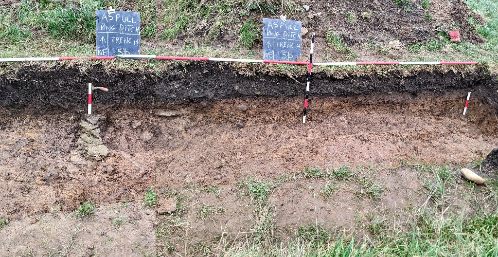 It seemed clear now that the small outcrop of stones (wider than first thought) was acting a sort of barrier between the hard stony area around the ditch in Trench 5 and the soft sandy clay that stretches all the way across the whole interior of the site (whether this is natural or manmade, the jury is still out).
Also work on Trench 1b, last time out, produced an area of large flat stones lying embedded the consolidated stony layer. To make sure we had revealed the full extent of these stones, Chris worked on the stony layer along the southwest wall of the trench cutting through it down to the sandy clay underneath. Andy, meantime, removed the small baulk in the middle of the trench. Both failed to produce a any more large stones. 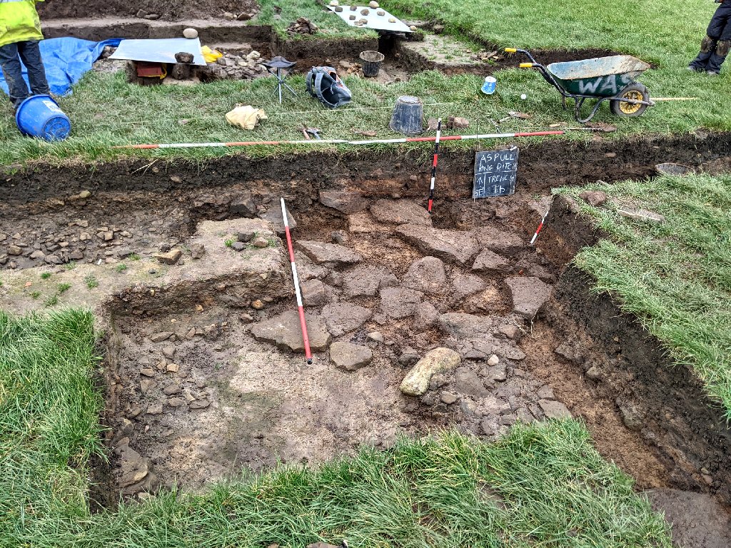 However when Martin arrived, it was decided to pull back the southwest wall just a couple more spade widths just to check it that area. This produced one more large stone and some smaller ones.
Meanwhile Susan continued digging down through the soft sandy clay on the southwest side of the clay mound in Trench 3a. As she progressed downwards the soft sandy clay became harder and stonier (mainly small pebbles).  She then moved onto the nearby west corner on the southeast edge on the east side of Trench 3a. More soft sandy clay was revealed and also a fleck of burnt bone which caused her to stop and cover up with one of the plastic trays. She finally turned her attention onto the small sondage (S3) in Trench 3a. She was also joined by John Trippier who got stuck into the adjacent sondage (S2). They both revealed more of the underlying soft sandy clay (light grey in John’s case) but this obviously is a work in progress.
Finally Bill asked Andy to dig through the consolidated stony layer in the sondage S3 in Trench 1b. This was so that Bill could add more detail to his section drawing of this trench. Under the stones Andy revealed the usual soft sandy clay, eventually reaching a harder stony surface at a depth of just over a metre from the surface. 
Tuesday 21th November
Day 51 – Six on site today – Bill, Chris, Jenny, Susan and John Needle with Peter joining in the afternoon. The day was much more pleasant than last time out, dry and surprisingly mild for the time of year.
The cut on the northeast side of Trench 3a (i.e. Trench 3b) had not produced the end of the stony layer. So instead of extending it one again, Bill ask john to extend the east corner of Trench 3a as this area had shown some signs of the stones petering out. With the help Bill John was able to extend the trench in the northeast direction by another half meter but after much careful trowel, the expected edge of the stones failed to appear.  He did however manage to produce a nice mottled clay section with some horizontal banding which looked like intermediate burning (John also found another couple of fragments of burnt bone).
Having previously exposed the north corner of Trench 3a, Chris and Jenny turned their attention to Trench 1b where large stones were showing up particularly around sonadage S2. Bill was curious to see if they were random or part of a pattern in that area. First of all they trowelled back the stony layer from the large stones already exposed to reveal their full extent. This showed that some extended in to southwest wall of the trench and also the small baulk on the southeast side of sondage S2. 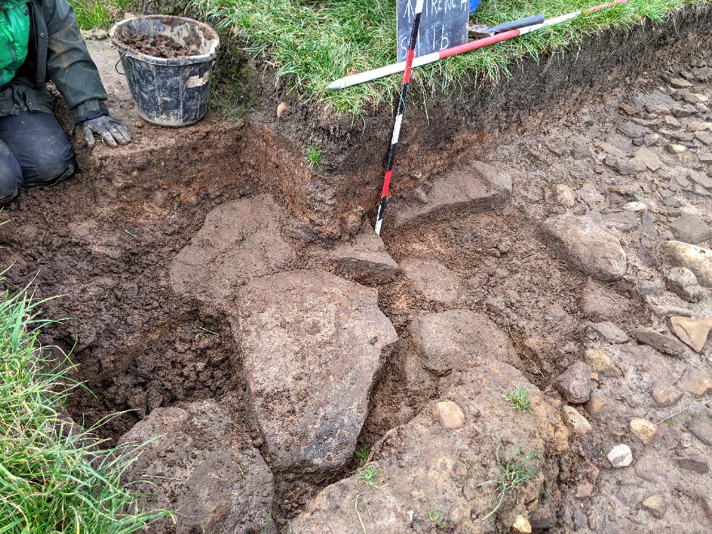 It was therefore decided to pull back the wall of the trench and remove a section of the baulk. This revealed the full extent of the large stones which seem to present a platform or perhaps a causeway leading to the sandy clay mound in Trench 3a (although if that was the case, why would they lie under the stony layer?).
Meanwhile Susan continued to investigate the stony southwest flank of the sandy clay mound. Last time out she had cut a slot along the section line Bill was trying to draw and had found a hard stony surface below the soft sandy clay. Bill asked her to follow this down the slope of the mound until show reached the bottom where the stones ran out. Before she started, Bill took the opportunity to take a photo looking down so that the stones could be recorded before Susan removed anymore.  When Susan reached the bottom of the stones on the southwest side there seemed to be an edge between the stones and the soft sandy clay in the rest of trench. Here Susan continued to trowel down but found no sign of any other layer. In the cut nearer the top of the mound however where Susan had clean the section, Bill thought he could see another layer of burning (?).
When Peter arrived, he took a look at Trench 5b where he had worked last time out. Bill had bailed out most of the water which had left the surface a bit sticky so Peter wasn’t sure if he could work on it. Bill thought he could work on the drier side (i.e. more towards the centre) which is where the section was uncertain, as the area around the outcrop seemed now to be understood. Peter therefore cut a long slot through the soft sandy clay until he reached a had stony layer which seemed more likely to represent the original natural surface (this is assuming the soft sandy clay is not natural).  When Peter finished, Bill was confident he would be able to make something of the section.
Thursday 16th November
Day 50 – Great turnout today with a total of eight on site. Joining Bill and Chris were Peter, Jenny, Phil and John with Dan and Susan from Liverpool joining later in the morning. With rain originally forecast in the afternoon we’d decided on an early start (9.00am) but as it turned out, we saw no rain all day.
Chris had brought some hessian sacks and material (surplus from his Huxley project) to use to protect our two pots over winter. When this pot was first discovered the weather was particularly dry, now that the weather is not so dry, the colouration in pot 2 is much more distinct. So, before covering it, Chris he took the opportunity to do a 3D scan with his iPhone. Bill also took a close up so that he could pick up the crisscross incisions on its upper surface. 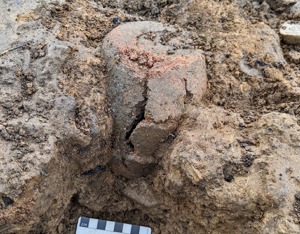
Having examined the newly exposed area around Trench 5b Peter decided it wasn’t too wet this week to have a go at trying to understand what was going on there. As explained before, the natural compacted gravelly surface seemed to be obvious where the ditch was, but as we move towards the centre, this surface is replaced by a clean soft sandy clay. Somewhere in between there must be an interface so, helped by Dan when he arrived, Peter took on the task of trowelling the whole area to see if this could be found. There was also the strange small apparent outcrop of bedrock stone dividing the two surfaces. At the end of the day, Peter and Dan where able to expose more of the two surfaces but the relation between the two was still eluding them. 
Meanwhile Bill helped John to widen the northeast extension in Trench 3a (we’re now calling Trench 3b). This was to primarily to align the northwest wall of the trench with the trench wall on the southwest side of the trench so that Bill could record the full section. It would also enable more of the stony layer to be exposed to confirm or otherwise its existence at the very end of the cut. After spending sometime cleaning the stones and section, John was able to show that the stones were still well represented at the end of the cut albeit lying under a thick layer of mottled clay.  He was also able to show that the thin black line was lying between the mottled clay and the stones, showing that the burnt area was also present in this area.
After finishing the northeast end of the cut, John took a look at the other end of the cut where it joined the main area of Trench 3a. Last time, a sudden drop had been detected at the edge of the area of stones embedded in the sandy clay mound. The sudden drop reflected the changed from embedded stones to the usual stony layer topped with a layer of burning as it entered the cut. After John had removed some of these stones, he was able to show a sandy clay base lying beneath them and the section revealed a thick layer of burning which followed the sudden drop. This gave room for a layer of mottled clay which we usual find lying above the stones and burnt layer.  John was also able to show the interface between the stones lying above the sandy clay and the stones embedded in the sandy clay mound.
The north corner of Trench 3a was still being a bit of a mystery i.e. the substantial area of burning could be a feature in itself or was it just more of the usual burnt layer. If it is the usual burnt layer, then are there stones underneath it and if so, are they the usual stones lying on top of the sandy clay or are they embedded (as seen further to the southeast). Jenny therefore was given the task of opening up a small cut along the northeast wall (which Chris had started last time out) to hopefully show what was happening in the section. At the same time Chris began trowelling back the burnt layer between the cut and the sondage (i.e. S6). He was anxious to leave a section the burnt layer intact for future reference. This revealed a layer of stones embedded in the sandy clay mound which seemed to be diving down towards the centre of the mound (not, as might be expected, the other way around). 
Jenny’s trowelling produced more stones and a convoluted black layer which at moment is difficult to understand. 
Bill was determined to get some recording done and was able to capture some values for his northwest to southeast section. He also wanted to get a good recording of the section across the sandy clay mound form southwest to northeast – he had previously made an attempt at this but he was look to complete a more comprehensive one which would include the latest cut on the northeast side (Trench 3b). With this in mind Bill ask Phil to trowel back the southeast wall on the south side of Trench 3a. The section revealed proved to be less than simple – the southwest side of the section was simple enough, matching the southwest section. However moving further along the section, the dark grey band representing the layer below the burnt layer, seemed to dip down and rise again before reaching the end of the section.  The mottled clay layer at this end presented diagonal banding, similar to the northwest section of this trench and the southeast section of Trench 1b. The floor of the section also changed over that middle section, tuning from soft sandy clay to harder darker clay and then back again.
Before Bill began recording the section he asked Susan to cut a section through the stones on the southwest flank of the sandy clay mound. This was so that this area could be understood and thus better recorded. It revealed the sandy clay mound going underneath the stony layer. Susan also found a harder layer under the soft sandy clay of the mound.  Recording sections is always a long and laborious procedure and it was almost dark before Bill, even with help of Peter, managed to finish this 13m long section.
Tuesday 7th November
Day 49 – Not a bad turnout today despite the predicted bad weather. Joining Bill and Chris were Andy, Peter Cooke, Phil Livesey and John Needle.
John was keen to get going so he was given the task of extending the cut on the northeast side of Trench 3a to check whether or not we had reached the end of the stony layer. Strangely though, after a further 1.3m there was still no sign of the end of it – although the layer did seem to be getting deeper.
Peter would have liked to get back into Trench 5b to see if we could get a better understanding of the natural surface. However the site was too waterlogged to be able to do anything so Bill asked him to look at the sondage at the southeast end of Trench 3a (i.e. S4). This was where the burning layer seemed end. In the adjacent sondage (S1) just two layers had been detected under the plough soil, i.e. a thick layer of sub-soil, then soft sandy clay (this was similar further down in the northwest end of Trench 3). The question was, what happens to the thick layer of subsoil as it approaches the end of the burning layer. Also what other layers (if any) lay beneath this.  After digging out more of the soft sandy clay, he reached a level of the harder stonier sandy clay, but Peter could not say for certain if there were any more layers. The result therefore was as usual inconclusive.
At the north end of Trench 3a in the area next to sondage S6, it wasn’t clear what was happening to the stony layer, particularly in the area of the sondage. Both Chris and Phil, who worked on the sondage, were insisting that there were stones in that area before the sondage was dug out. However Bill said he couldn’t see much if any in the west corner section of the sondage, just the red/black layer which matched the situation on the other side of the baulk. Bill therefore asked Chris to trowel the surface next to the sondage to investigate what was happening here (i.e. whether there was an edge to the stones). At the same time Phil re-trowelled the section wall of the sondage to see if the issue could be resolved. Phil’s trowelling showed that there was just a small cluster of stones on the southwest side but nothing in the west corner. However on the northeast side, there did seem to be layer of stones – it seems therefore that this could be the edge of the stones.
As Chris trowelled back from the stony area, more stones were revealed (as the others, embedded in the sandy clay mound) but then suddenly a gap of soft sandy clay developed before reaching the prominent layer of burning.  Chris thought the clump of stones seemed to form a feature and as he cleaned more of the clay from it, one of the stones revealed to have another surface with grooves on it.
 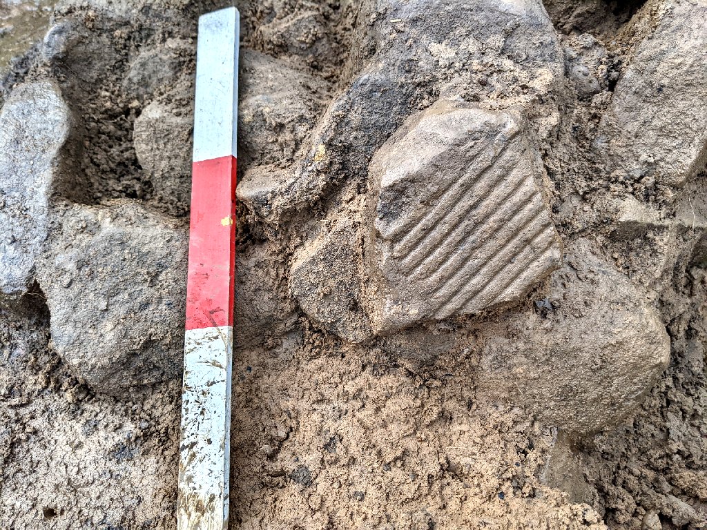 The stone seems to have broken off a bigger piece but significantly not the big stone (which was very close) as the groove spacing was not the same. This is our third stone with grooves on (may even be a fourth as Bill found another in Trench 1b which has yet to be confirmed as manmade).
Meanwhile Andy was given the task of opening another sondage in Trench 1b on the alignment with the Trench 1c extension. This was so that Bill could complete his section drawing along the northwest/southeast profile. Pretty soon after removing the mottled clay layer, Andy revealed more large flat stones laying just under the layer of stones.  Phil, after finishing in sondage S6, was asked to look at the south corner of Trench 3a. This was again so that Bill could complete his section drawing across it, which will go across the trench from the southwest to the northeast.
  Trowelling the southeast section wall revealed the layers previously see on the southwest wall i.e. the mottled clay layer under the plough soil with the red/black and light grey layers and eventually the bright orange layer.
As the rain came in in the afternoon, Bill didn’t get chance to record the two sections. However he did manage, with the help of Andy, to record a series of levels using the dumpy level. 
Tuesday 31st October
Day 48 – Just four again today with Peter Cooke joining Bill and Chris with Martin Trumble joining in the afternoon. It was supposed to be dry today but the dizzily rain continued throughout the morning but, despite this, we did manage to make some progress.  To try to find the extent of the stones in the east corner of Trench 3a, Bill and Chris extended the northeast side by another couple of spade widths. This gave Chris some room to trowel down through the red/black layer to reveal the stony layer below. Chris was being especially careful as it was in this area that the pot sherd was recently found. Although no more signs of a pot emerged, he was able to see that the stones were being to thin out.
Meanwhile Bill took it on himself to reduce the height of the spoil heap which was now towering over the southeast side of Trench 3a. When finished he went over to work on the northeast cut which he extended by another half metre with the idea of finding the extent of the stony layer in that area. As he trowelled down through a thick layer of mottled clay, what was particularly noticeable was the depth of the red layer (which Chris had noticed the day before) – upto 4cm thick with only patchy areas of black underneath.  After trowelling through this, Bill eventually came across the stone layer embedded in grayish clay and was able to detect the first signs of its end.
Peter had set his sights on trying to fathom out what was going on the northwest sector of the ring ditch (where Martin had previously been working). When we excavated the ditch in Trench 5 last year, the natural surface had clearly been revealed. It was represented by a half metre thick layer of compacted sandy clay embedded with fine pebbles – a very typical glacial till. However this year, the extension of Trench 1c towards Trench 5 had not detected this layer, just clean soft sandy clay (albeit with some subtle colour changes). Opening up the interface between the two trenches (i.e. Trench 5b) must surely reveal what was happening to the natural gravelly surface. The interface seems to be marked by a small outcrop of bedrock (or that’s what it looks like). After some gardening to remove the accumulated vegetation, Peter was able to reveal the surface uncovered last year (this area latest year was originally thought to be the ditch). When Martin arrived he was able to give the area on the edge of the ditch a good clean.  We’re now in a position to explore the interface in more detail which will hopefully answer the fundamental question about the nature of the original ground surface inside the ring ditch.
Monday 30th October
Day 47 – The weather is being particularly unpredictable at the moment meant that this week’s arrangements were done at very short notice. As a result just four hardy individuals on site today i.e. Bill, Chris, John Needle and Jenny Harrison form the Wyre Group.
Chris was keen to get a good 3D scan of the large stone in sondage S6 with the strange incisions, so that he could study their construction in detail. He therefore spent some time cleaning it before completing the scan with his iPhone.  Chris pointed out that the other marks on the stone resemble a monkey face (once seen, it can’t be unseen). At home he produced this 3D model. Chris also produce a 3D model of the small stone found on Day36.
Jenny was tasked with cleaning more of the stones around the large stones recently discovered on the southeast side of Trench 3a. Meanwhile Bill and John undertook the task of removing more of the spoil heap so that Trench 3a could be expanded in the southeast direction to see how far the stony layer extended in that direction.
After Chris finished his work on the stone in S6 he turned his attention to the new cut on the northeast side of Trench 3a. The extension, although 2m long, had not reached the end of the stony layer – so he extended the cut by another three quarters of a metre but still no sign of the end of the stony layer.  The overlying material however was become more reddened perhaps has a result of the heat from the burning event. The overlying mottled clay was also getting deeper.
Meanwhile, after Bill and John had cleared enough space on the southeast side of Trench 3a, they made a start on extending the east end of the trench in the southeast direction. This produced more stones lying under the red/black burnt layer. It was decided therefore to extend the trench all the way to the east corner. This gave enough room for Jenny to join Bill and John in trowelling the surface down through the red/black burnt layer. This again revealed more stones including some more large ones. The red/black burnt layer was getting particularly thick in this area. It also had a thick layer of greyish sandy clay lying between the red/black layer and stones.
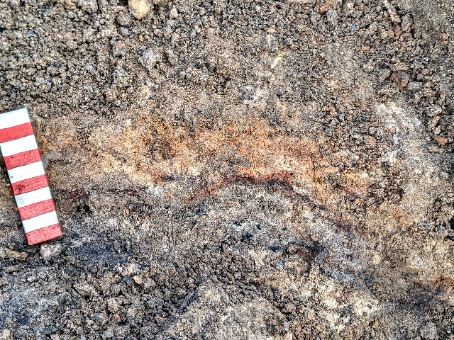
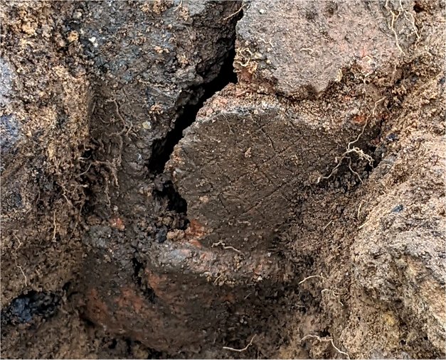
It was while trowelling through this that Jenny pulled out a piece which Bill thought looked like a a thick walled cortex (i.e. outer shell of a stone – something we have come across many times before). Although covered in blackish clay, John thought he could detect a rim and so Bill took it away to be washed. As the blackish soil was removed, the unmistakable shape of a sherd of pottery began to emerge. Its surface was reddish and its section revealed a black interior. The crisscross pattern on its surface however confirmed that this was part of an large urn dating from the mid Bronze Age. 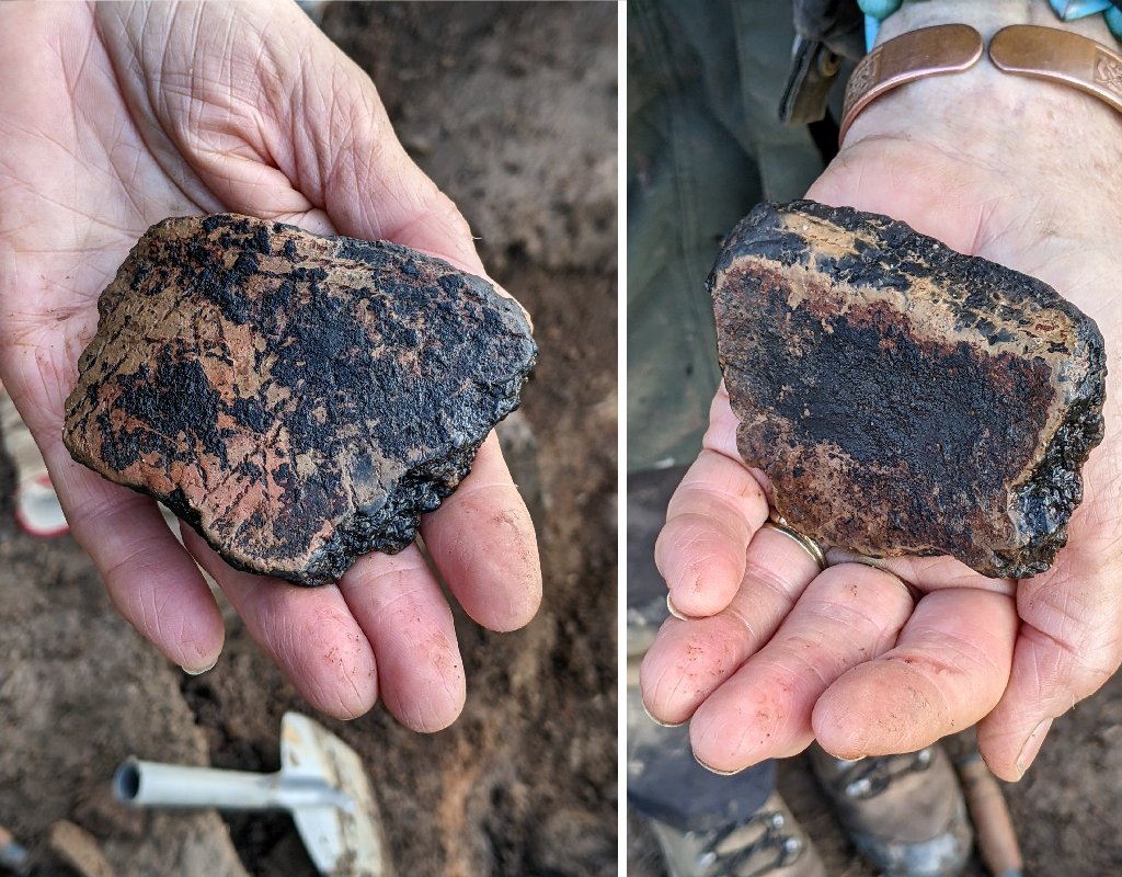 Careful trowelling revealed no more pieces in the immediate area which suggests that another cremation on the site had been disturbed before the burning event had occurred and the site sealed by the mottled clay layer.
Saturday 21st October
Day 46 – Today we were joined by members of Chris’s Cheshire group i.e. the Border Heritage Archaeology Group – they were Cath Harris, Penny Jones and Phil Cox. Storm Babet had also caused the cancelation of another trip on Winter Hill so both Peter and Martin were also able to join us.
After a brief tour of the site Chris set the BHA group on extending the cut on the northeast side of Trench 3a. This revealed more stones topped with the red/black line and also the mottled clay layer. This was reminiscent of the stony layer in nearby Trench 1a but here the stones seemed more substantial. The group continued extending the sondage and by the end of the day the cut had reached almost 6m from the edge of the trench and still no sign of the end of the stones.  The stones themselves were still sloping down but so was the ground level (as can be seen from the level string line) which meant the depth remained almost the same.
In the meantime Martin was given the task of investigating the newly exposed area at the northwest end of Trench 1c where in interfaced with Trench 5 (which in future will be referred to as Trench 5b). The natural ground surface had been shown to be particularly clear in Trench 5, being represented by hard compacted sandy clay embedded with small pebbles (a typical glacial deposit). A small ridge of stonework had also been exposed which was almost certainly an outcrop of bedrock. When the trench had been extended towards the centre however, this natural surface seemed to disappear, replaced by a thick layer of fairly clean soft sandy clay. The newly exposed area was giving us opportunity to try to understand what was going on in this area. The ultimate goal was to establish if this clean soft sandy clay, which we have been seeing all over the interior of the site, was a manmade deposit or a natural formation. At the end northwest end of Trench 5b, Martin was restricted by the pools of water covering the small outcrop. He was however able expose some stones embedded in soft sandy clay but they were certain not part of the outcrop.  The soft sandy clay here was not clean having small pebbles in it with the occasional fleck of shale but did not have the feeling of being the natural ground surface.
Martin had to leave early at which point Peter took over trowelling the surface all the way back into the Trench 1c cut where the soft sandy clay seemed quite pure. He was able to reveal changes of colour and texture in the sand but was unable to determine exactly where the changes occurred. 
Before taking over from Martin, Peter had been tasked with extending the northwest end of sondage S6 in Trench 3a. This was to examine the extent of the large angulated stones Chris had come across in the bottom of the sondage. This showed that the stones were quite localised on the southwest side of the trench, therefore seemingly associated with the stones seen in S5 on the other side of the baulk.  Further work clearing the sandy clay from the bottom of large stone in the sondage, revealed something quite remarkable – the bottom edge of the large stone was found to have long parallel groves cut into it.
  We had previously seen something similar on a stone much smaller in size found near the embedded pot on Day 36 which he had tended to dismiss as a possible later inclusion. This stone however was much bigger and is most certainly embedded in the sandy clay mound – this is total unprecedented.
  Bill though he had seen another possible example on the southeast edge of Trench 3a where he had cut a extension in search of the edge of the red/black layer. He therefore widened this cut by taking out another spade’s width on the northeast side he was able to expose more of the stone.
  This revealed the stone to be quite large, but the grooves were unlike the others being most likely created by natural erosion.
After photographing the various trench activities, Bill, help by Peter spent some time recording a section across the centre of the mound i.e. from the southwest side to the northeast trench extension.
Wednesday 18th October
Day 45 – The weather being its usual unpredictable self this time of year, our visit today ended up being switched from Thursday, subsequently only Bill and Chris were able to brave the elements.
They thought that, as a priority, they needed to get a better understanding of the sandy clay mound in Trench 3a. They decided it would be a good idea to extend the southeast side sondage S6 but at 90 degrees towards the northeast. On this side of the trench, two areas of burning had been detected which Bill thought represented the red/black layer, the edge of which disappeared beyond the edge of the trench. Extending the sondage between the two areas burning would determine if the arrangement is the same as seen on the northwest side of the trench, i.e. the sandy clay mound going under the red/black layer. Chris found however a layer of stones embedded in the sandy clay which reached all the wall to the edge of the trench. The section confirmed however that the red/black layer lay on to pf the stones. It was therefore decided to extend the sondage another 0.5m beyond the edge of the trench in the northeast direction. More stones we exposed seemingly dipping down similar to the other side of the mound and red/black line could be seeing following the stones in the downwards direction. 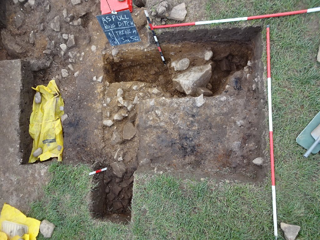 Chris then turned his attention to the original section of S6 and as he dug down on its southeast side, he was finding subtly different layers of the sandy clay. At a depth of about 0.6m he came across a stony layer which he thought might be the natural. On the northwest side of the sondage, the stones appeared to be large and angulated, certainly not what you would expect from a glacial deposit.
Meanwhile Bill thought it would be a good idea to look at the southeast side of the sandy clay mound so that a complete picture of the mound could be established. On this side of Trench 3a, there had been no sign, except at the edges of the red/black line which most likely lay under the spoil heap. So before he could start, Bill needed to move the spoil heap in the area he was interested in i.e. in line with S6. Having achieved this (?helped by Snowy our site dog), Bill was able to expose more of the sandy clay mound as well as another large stone but no red/black line. There was only one option, Bill would have to extend the trench in the southeast direction and bit the bullet to remove more of the spoil heap.  After extending the trench another 0.5m, Bill was eventually able to find the red/black line, seemingly defining its position on the southeast side of the central mound.
To finish the day, Bill turned his attention to the southwest side of the mound where he had discovered previously that the stones, covering the mound, were dipping down. He therefore cut a sondage across the edge of the stones to reveal the extent and depth of the stones in this area.  This enabled Bill to use the Moasure device to record a section across the mound from the southwest side to the northeast side.
Tuesday 17th October
Day 44 – Bill back from his hols was keen to see what progress had been made. However only Chris could join him to day and, due to Bill’s slight jet lag, they only met up about just before lunchtime.
Chris showed him the progress made the previous week in the various sondages, particularly in Trench 3a (i.e. S6 & S7). Chris decided to widen S6 so that the large stone in it could be better understood. This revealed more stones which seemed to be forming a circle around the sandy clay bank, suggesting that the stones were defining it.
Bill was keen to expose the stonework on the other side of the mound to see how deep it was and how far it extended from it. However before he could start, he had to deal with the large piece of burnt wood from which a sample as been taken and sent off for C14 dating.  All the pieces were collected as best as possible and bagged for future analysis.
When he eventually cleaned off the soil from the stones, a distinct bank emerged centring on the sandy clay mound. This seems to be suggesting that the mound is the central feature of the site. Projecting the slope of the stones, it would appear that the mound was much higher and, when covered by the stones and mottled clay layer, must have been quite visible in the landscape.  All we are seeing now is its truncated remains.
Thursday 12th October
Day 43 – Joining Chris today were Peter, Bob, Mark and Martin
Peter joined Chris in Trench 3a helping him to extended the new sondage S6. A very large stone was discovered just below the surface and again, seemed to be on the boundary of the orange sand and possibly lining up with the large stones in S5 (do we have a structure at last?). Also, a new layer appeared which looked a slightly greyer firmer sand.
Martin also worked on Trench T3a extending the southeast edge to expose more stones, but no sign of the red/black line (again spoil heap might have to be moved if we are to find its edge in this direction).
Mark and Bob completed the newly exposed area in Trench 1c where it enters into Trench 5, bringing it all down to the same level. 
The day concluded with a full clean back, followed by a drone survey which, enabled Chris to produce the following image with drawing overlay.
Tuesday 10th October
Day 42 – While Bill was on holiday (who said again) Chris was in charge this week. Joining him were Peter, Jenny, Christine Barbour-Moore, Phil, John Needle & Snowy, our site dog.
Phil and Jenny started a new sondage in Trench 3a (S6) to study the red/black layer in section. This was to confirm if it was rising as it approached the orange sand area and thus lie over it (similar to the other side of the baulk in S5).  The section produced proved that it was.
Chris worked on the opposite side of Trench 3a (in the east corner) around a large slanted stone which seemed to define the southern edge of the orange sand. As he opened up a new sondage (S7), the red/black line could be seen in the section but stops near the large stone.  His opinion was that it probably heads off under the spoil heap. Some fragments of cremated bone turned up in this area, so he stopped work here.
Peter, John and Christine worked on Trench 1c extending it towards Trench 5 to investigate the extent if there were any more stones in this northerly direction. After cutting through the topsoil and subsoil they were able to trowel down to the sandy clay layer below (Snowy staying several hours catching the spoil).  Eventually the extension joined up with Trench 5. This showed that, apart from a few isolated patches, there we no more stones in that area.
Wednesday 4th October
Day 41 – With the weather becoming more unpredictable, today was a last minute decision and so the consequence was on three on site today – Bill, Peter and John Needle. Nevertheless good progress was made.
After a bit of bailing out the water from the ground sheet covering Trench3a John took on the task of taking the spoil heap further back. This was so that he could extent the southeast edge of the trench on the west side. Last time John Smalley had found the edge of the burnt and mottled clay layer so the idea was to see where it was going. A 0.5m by 1.5m long cut there was made into the southeast side and after the topsoil had been removed, John was able to trowel down onto the top of the mottled clay layer. This also revealed the edge of the burnt layer (identified as a dark orange band) which could be seen snaking its way in a northeasterly direction.  As it reached the edge of the cut where the stones embedded in the sandy clay bank where, it turn to the southeast (more work needed here to find out how far in this direction it goes).
Meanwhile Peter continued with his work in Trench 1c. Bill asked him first to trowel down the southwest section so that he could record it. This showed that the sandy patch revealed earlier was unlike other patches in that the burnt layer had been cut through at this point suggesting the patch is a later intervention. He was also able to confirm that the burnt layer was diving under stony layer spreading across the northwest end of the trench.  We still didn’t know the full extent of this stony layer which seems to be imbedded in the subsoil under the plough soil (he stones also seem to be of a different material than the rest, all having a pale green tinge to them). Bill help Peter therefore to extend the trench by another metre at the northwest direction.
  This seemed to at last reveal the end of the stones about half way along (although there were some random stones in the subsoil beyond). Before they left for the day Bill and Peter was able to record a 6m section of this trench.
Thursday 28th September
Day 40 – Great turnout today with nine on site. Joining Bill and Chris were Peter, Andy, John Smalley and John Needle with Patrick and Martin joining later. Great to see Jenny Harrison from the Wyre group also joining us for the first time.
While Bill showed Jenny around the site, Chris, helped by the two Johns, took on the task of expanding Trench 3a in both the southeast and northeast directions. This was to see if they could establish the full extent of the exposed sandy clay mound which has been truncated by ploughing. Meanwhile Peter set about investigating the northwest end of the extended cut in Trench 1b (we’re now going to call it Trench 1c). At the same time Bill asked Andy to look at the sondage at the other end of Trench 1b (i.e. S2). This was to see if he could establish the strata below the stony layer. Eventually after digging through another 20cm of soft sandy clay, Andy found no change apart from the odd stone, in the consistency of this layer.  Using the auger and the steal probe, Andy perceived that the soft sandy clay went down another 80cm (note the inserted probe in the above photo).
While Chris and the two Johns continued with their task to expand Trench 3a, Jenny was asked to trowel the stony layer in this trench in the area southwest of our latest pottery find. This was so that the full extent of the stony layer could be appreciated. As expected, when the newly exposed area of Trench 3a had been carefully trowelled, the edge of the burnt layer could be seen almost completely surrounding the sandy clay mound – the exception being on the southeast side where more stones were beginning to emerge (one particular large stone seemed to be embedded in a soft dark soil). Bill was able to record the edge of the burnt layer by tracing around it with the Moasure measuring device.  More flecks of cremated bone also were coming out of the newly exposed burnt layer so care was being taken in that area. Bill asked John S to examine the south corner of the trench on the southeast side. This was to establish the end of the burnt and mottled clay layers in the section which could be seen in the adjacent section but not on the southeast section of Trench 3a. John detected yet more flecks of cremated bone there but, as he trowelled down, he was eventually able to establish the end of the burnt and mottled layers in the section just on the edge of a group of stones.
Meanwhile Bill helped Peter in trying to understand what was going on in Trench 1c. By trowelling the section on the southwest side he was trying to see where the burnt and mottled clay layers ended on this side. On the other side it quite obviously ending where the large area of consolidated stone began. However it was found to to be diving underneath the stones which seemed to be embedded in the subsoil just below the plough soil. Peter endeavoured to cut through this layer of stones to see what lay beneath. This revealed a soft sandy clay in the middle of which a circular patch of subsoil began to appear. Thinking this to be a possible post hole, Bill asked Peter to half section it.  Unfortunately we where disappointed to find it to be just a shallow cut in the sandy clay.
When Patrick arrived, Bill asked him to look at a small area to the side of of the first burial urn. This was to see if we could establish how deep the pot went as it wasn’t clear if it cut through the burnt layer. After carefully excavating a short section on the southwest side, Patrick was able to confirm that the vessel did not go any deeper than the burnt layer as the red and black layer could be seen going under it. This means that the pot is likely to be up side down with just the top rim section remaining as originally thought.
Before recovering the find Chris took photos so that he could create a 3D model of it. He also took a sample of charcoal from the inside of the pot as well as a sample from the burnt layer from the centre of Trench3a, so that Bill could send them off for Carbon14 testing.
When Martin arrived in the afternoon, Bill asked him to take another few centimetres off the S4 in Trench 3a to see if the layers in the section could be established. The result seemed to show the deep layer of subsoil, as seen in Trench 3 and the first sondage (S1), seemed to thin out moving towards the centre of the mound. The section in S4 seems to show this thin layer of subsoil ending, being replaced by the burnt and mottled clay layers.
One of the assumptions about the burning event, as been that the heat caused the discolouration of the stones which are iron-rich sandstone. Bill noticed that on some of the stones the discolouration only appeared as a band across the middle of them. It is difficult to imagine how this could have happened as a result of a burning event which would surely have effected to whole of the upper surface. It seems more likely that the discolouration is do to staining of the stones, the red and black layer being formed by some other chemical reaction.  However many other stones do show that they have been affected by extreme heat. The example below shows the reddened fabric of the stone in the corner where a piece has broken off.
Tuesday 26th September
Day 39 – With uncertain weather conditions, just three on site today – Bill and Chris with Patrick joining later in the morning.
It seemed clear that more work would be needed in the southeast area of Trench 3a. To do this, it was obvious a large section of the soil heap would have to be removed. Bill and Chris took on the challenge and by the time Patrick arrived they had taken a good half metre off it in preparation for later work.
Rather than extend the trench in the southeast direction today, it was decided to see if we could chase the edge of the burnt layer on the northwest side. Chris therefore de-turfed a section on this side leaving a short baulk so that the section showing the sandy clay going under the burnt layer, could be maintained. Having found the edge of the burnt layer, Chris continued to extend the trench in the northeast direction by about a metre. Surprisingly the burnt layer initially moved away from the centre of the sandy clay before returning to curve around it.  Meanwhile Patrick worked on the northwest end of Trench 3a in the area adjacent to S5 trowelling it down to the stony layer. This was to determine its edge as it wasn’t clear in the section how far it extend in this area.
Bill had another go at the joint sondage in Trench 1a (i.e. S3, S4) to try to get a better understanding of the substrate under the stony layer. Trowelling the section again he thought he could see the lower layer again but it was far from clear. The cut that had previously been detected in S3 turned out not to be one , just a thicker section of the stony layer in that area. 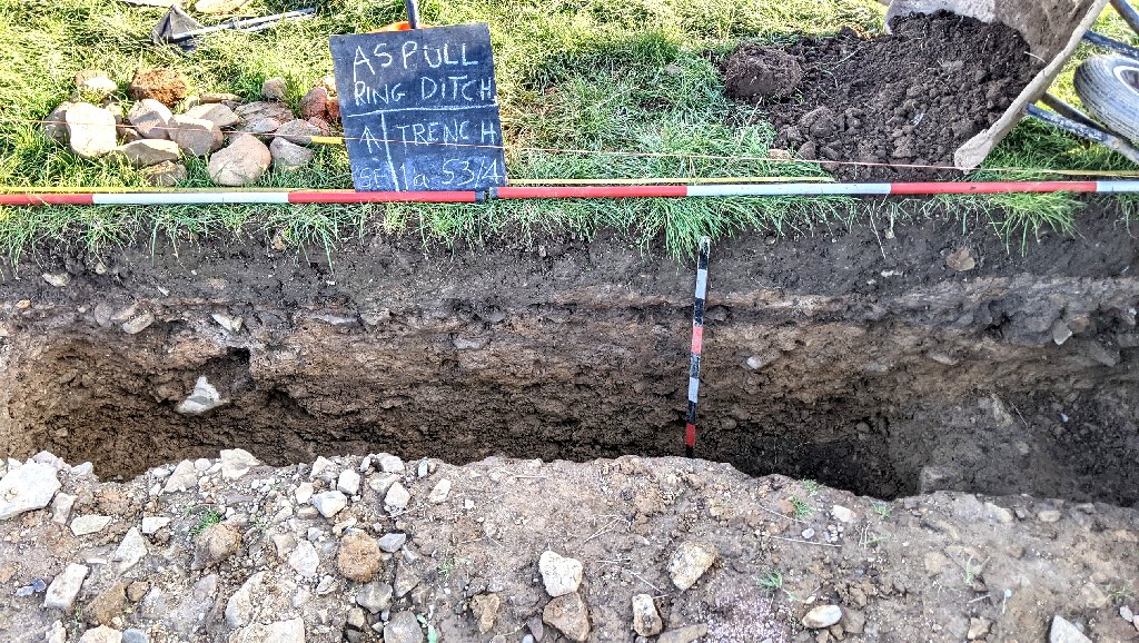 Bill also worked on the base of the trench taking another 10cm or so of the bottom taking out more cobbles mixed in a soft sandy clay. However unfortunately still no sign of a hard surface.
Saturday 23rd September
Day 38 – Today Chris’s was joined by his colleagues from Border Heritage and Archaeology Group from North Wales/Cheshire i.e. Penny Jones and Phil Cox as well as Chris’s partner Denise. 
Work concentrated in Trench 3a on the area to the east of the second urn which was extended by de-turfing to investigate a collection of stones close to the spoil heap (which again had to be moved out of the way).
Once they had cleaned the surface, there was a clear semi- circular patch of stones closely packed together in the orange sandy layer. Two areas of cremated bone and burnt wood were identified at the east end of the trench (marked by the small container boxes).  It is possible that they are on the interface between the top soil and orange layer, so they have been left for closer examination next week.
Thursday 21st September
Day 37 – Great turn out today with eight on site. Besides Bill, Chris and Patrick, we had Peter, John Needle and the three volunteers from Liverpool i.e. Susan, Lisa and Dan.
Straight away Peter and Dan set about extending the cut on the northwest side of Trench 1b in search of the limit of the stones in that direction. Susan continued working on the sondage (S1 Trench 1b) she started last time uncovering more of the stony layer. Lisa meanwhile was give the task of looking at the patch of sandy clay void of stones in the middle of Trench 1b to see if we could get a better idea of its reason for it being there. To do this, she trowelled down a section of the of the northwest wall of the trench. This clearly shows the sandy clay going under the stony layer and, as the mottled layer covered the whole area, it seems this patch of sandy clay, existed prior to the sealing by the burning layer and covered the mottled clay layer (could it have been robbed of its contents in antiquity?). 
Bill was also keen to understand what was going on in the sondages in Trench 1a (i.e. S3 and S4). Previously he had detected a lower layer in S4 which he couldn’t see in S3. To see what was happening between the two, he endeavoured to join the two together. When finished Bill found he was unable to detect the lower layer, even in the original sondage. He also was finding it difficult to establish the depth of the sandy clay as, what was thought to be the bedrock base, turned out to be just stone cobbles in the soft sandy clay. 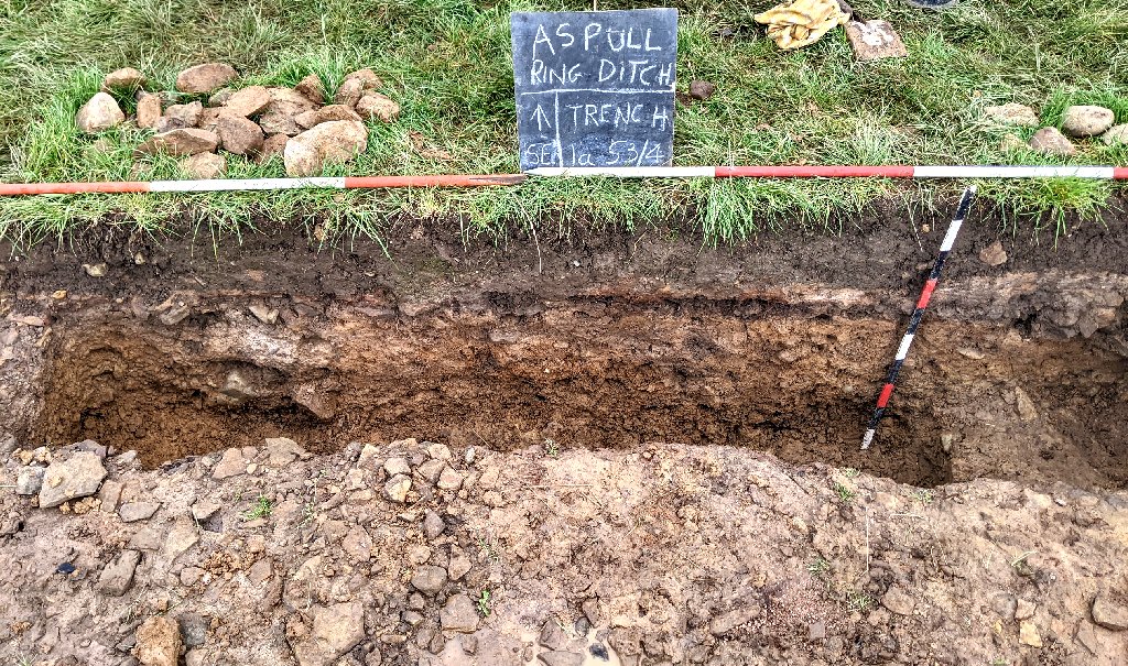 Some of the stones were quite large (up to 20cm long) often broken but strangely with very sharp breaks suggesting recent activity rather than glacial.
In Trench 3a, Bill asked Patrick to extend the sondage on the northeast side (S5) towards the centre of the mound. This was so that the full nature of the sandy clay could be seen i.e. how it went under the burning and stone layer. By the time he reached the end of the trench, Patrick had revealed a thick layer of mottled clay overlaying the distinctive burning layer but the stony layer only began to show right at the end of the trench. However other larger stones were appearing in the sandy clay layer below. 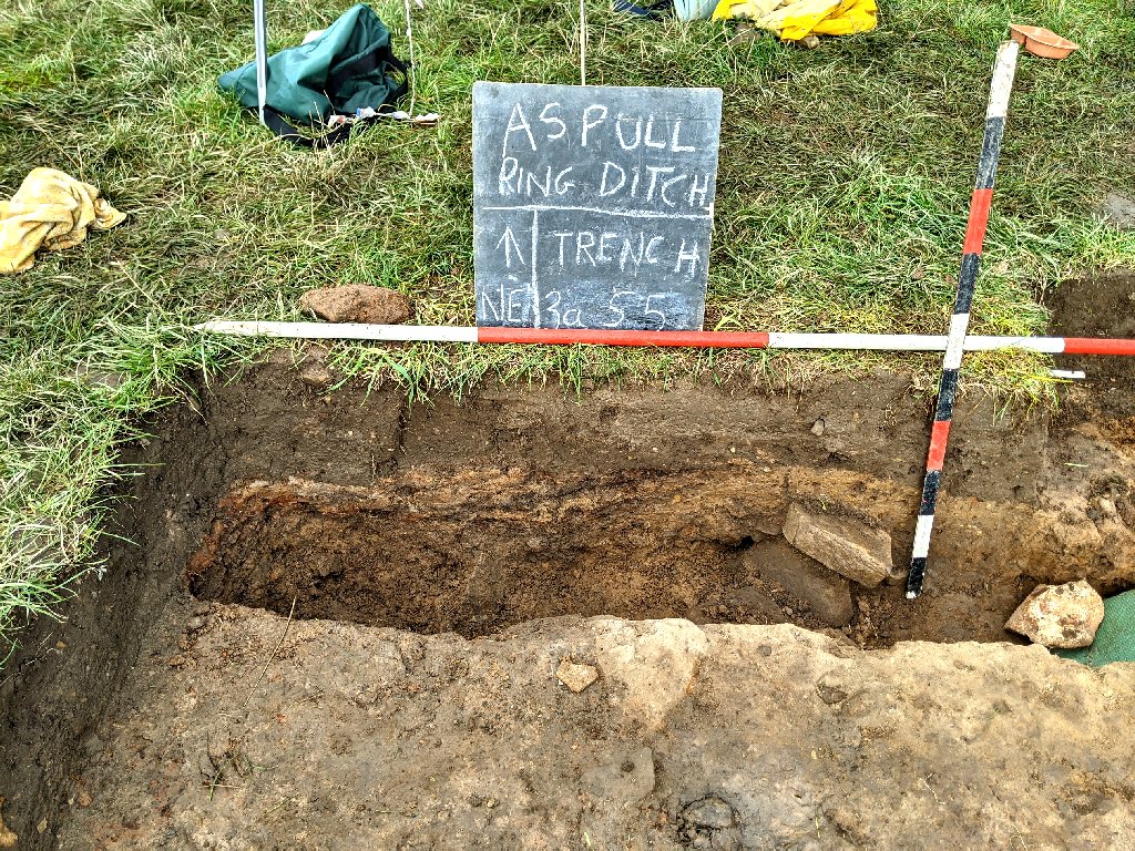
Meanwhile Chris and John took the opportunity to extend the area to the southeast of S5 in Trench 3a – by 25cm in the northeast and southeast directions. This was to examine the extent of the soft orange sandy clay (and stones embedded in) in the area to the east of our second pot location. This work just revealed more stone embedded in the sandy clay but tantalisingly there were small fleck of cremated bone tuning up (John thought he had stumbled on another pot just a few inches north of the first but the red gritty material turned out to be just a disintegrated stone).  Significantly there were no sign of the burning layer or mottled clay layer showing in this area. We can only imagine this area as been truncated by ploughing.
By the end of the day Peter and Dan had extended their trench (Trench 1b S2) by another 1.5m but still the stones kept appearing. However here the stones seem to be buried in the sub-soil with no sign of burning our mottle clay layer. Meanwhile Susan had finished cleaning the burning layer from the stones in S1 (Trench 1b). 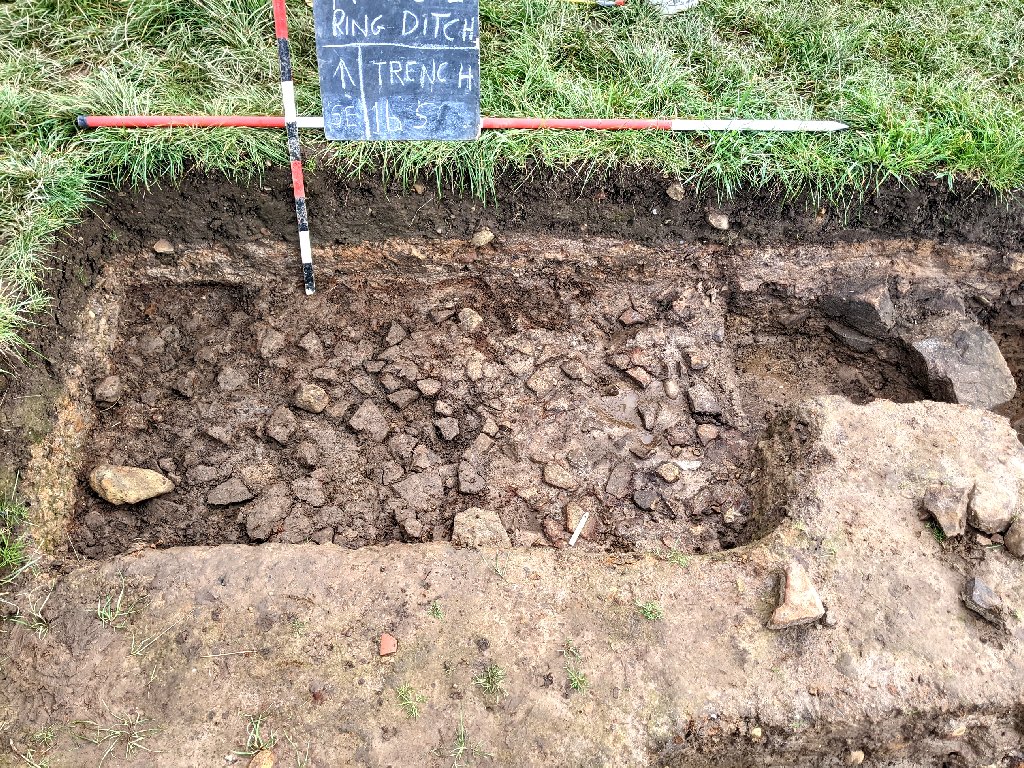 Strangely though, when one of the stones came loose, the underside revealed a thick layer of burnt material. Closer examination showed this to a have crisscross pattern, the product perhaps of a woven basket (strange though to have it within the stone layer).
Thursday 14th September
Day 36 – On site today were Bill, Chris and Peter with Patrick joining later. We were also joined by three new volunteers from the Lunt Meadow Project who visited us on Monday. These were Dan Fairfield, Lisa Stanway and Susan Rimmer. We also had a visit from Ron Cowell himself who is semi-retire but says he seems busier than ever.
Before Ron’s arrival, Bill got our new volunteers going on the sondage extension in Trench 1b (i.e.S2). Lisa and Sue were give the task of trowel soil off the stones while Dan was give the job (helped by Peter) of extending the trench by another metre in the northwest direction. Previous work had shown a gap at this northwest end with stones reappearing on the northwest side. The extension would hopefully see where the stones ended. Chris in the meantime continued investigating the southeast corner of Trench 3a where more stones where beginning to emerge. Patrick, when he arrived, join Chris in Trench 3a where Bill asked him to extend sondage 5 towards the urn this was to see if a cut could be detected which the pot had been placed in.
When Ron arrived, Bill took him around the site and was amazed at the amount of effort we had put in to dig out the ditch feature in our trenches (his view on the strange outer ditch in Trench 3 was that it was natural). He was intrigued by out central mound features and spent sometime trying to understand what was going on. His thoughts were that perhaps reason we had deep sections of soft sandy clay was as a result of hill wash and therefore natural (although the sandy clay containing our second urn could obviously not be natural). He was particularly intrigued by the mottled clay layer which could represent different events at different times. Although had to admit that these events must have occurred after the event producing the red/black layer.
During lunch Chris gave Ron his collection of small pieces of flint he had collected mainly from the area around sondage 1 in Trench 3a. Ron his certainly well placed to judge these finds having found thousands of them on his site at Lunt Meadow, all from the Mesothic period. 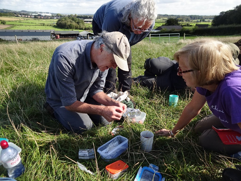 His comments were that most had been worked and one was certainly a tool i.e. a scraper – most likely Mesothic but he couldn’t say for sure as these were also produce in the Bronze Age.

After lunch, while Lisa continued trowel in the sondage 2 extension, Sue was given the job of trowel down to the stones in sondage 1 in Trench 1b. Work had stopped here when the burnt layer appeared. Sue was able to re-establish this layer before removing it to reveal the stones below.
The area that Lisa had been trowelling produced a similar spread of consolidated stones. However there was just one large stone on the the southeast side.
The 1m extension Dan and Peter had been asked to open, was still producing stones albeit at a higher level just under the plough soil. They now seemed to be lying in what appeared to be subsoil and strangely angled up towards the centre. It was decided to extend the trench another half metre to see if the end could be detected. This time there were signs of the stones petering out although some could still to be found in the apparent subsoil.
All this time Patrick had been slowly nibbling through the sandy clay, eventually reaching the wall of the urn without seeing any change in texture. This proved that the pot had not been placed in a cut in the sandy clay. It also revealed the pot to be quite small and although broken its contents seemed to be still intact.
Meanwhile Chris, working in the east corner of this trench was struggling to understand what the arrangement of stones meant. They seemed to be lying in an area of sandy clay that was darker than the area where the urn lay. In fact one of the stones had three very straight parallel lines cut into it (more medieval than prehistoric).
The sandy clay in the whole area on this side of the trench seemed to be a darker orange and softer than the area where Patrick had been working (Patrick had commented on how hard the sandy clay was to cut through). It could mean therefore that a separate fill of sandy clay existed on the southeast side or was just the result of the sandy clay drying out on the northwest side. To investigate the possibility of an interface between the two areas, Bill cut back a section in the sandy clay straddling the two. This produced no sign of a boundary between them suggesting that the sandy clay was just become hard as it dried out.
Wednesday 13th September
Day 35 – Today Chris and Patrick welcomed visitors from Greater Manchester Archaeological Advisory Service i.e. Ian Miller and Ben Dysen.
Ian had not see the site since his visit early last year when we had just started to open Trench 3. Ben had not seen the site before but both were amazes at our progress, Ian suggesting it was the best archaeological site in the GM area at the present time. Ben asked a strange question about whether we had come across any sign of clay lagging at the bottom of our ditch to make it watertight. A strange quest as it’s something more common in the medieval period on moated sites and later for canals but we hadn’t been aware that that was something the ancients did.
Both were also fascinated with our two cremation urns we’d found. Ian saw no issue with us removing the latest one without reporting it to the coroner as, until it has been removed, there was no evidence of human remains. He also suggested that when we decide we need to remove the first one (we we would like to before winter) he would be able to contact the coroner to give the go ahead. He also said that we would need to speak to somebody regarding eventual storage of the material – he suggested Wigan Museum should be given the first choice (Patrick said he would speak to Ian Trumble at Bolton Museum who would know who to contact). Regarding post-processing our second urn (the contents of which seem to be intact) Ian suggest we use the labs at Salford University as they have the equipment and have the staff to to give advice (this would certainly be a more cost effective way of dealing with this trick find). All we need now is to find a way of removing the pot without disturbing the contents.
Not a great deal done today but Chris and Patrick did manage to extend the area around our second urn by about 20cm in both the northeast and southeast directions (Chris, in the process, finding some more small pieces of cremated bone on the southeast side ). Chris also took the top soil off the northwest part of the trench revealing the mottled clay layer underneath.
Monday 11th September
Day 34 – Four on site today, Bill, Chris and Peter with Patrick joining after lunch.
Busy day today as we had visits from various interested parties. First was Dave Berry from the Wyre Archaeology Group – just visiting (there was a thought that some of there members might want to join our excavation team – however they have a number projects themselves at the moment keeping them busy). Just after lunch, our second group of visitors arrived – five members of Ron Cowell’s team excavating on the Lunt Meadow Project (Ron had intended coming himself today, but was unable due to car problems). All are visitors today showed great interest in our site and were particularly impressed with the cremation urn.  We know the urn is siting in what is left of the mottle clay layer but, on closer examination, it also looks like the red/black layer is continuing underneath it. If this is true it must mean the urn was inserted after this layer was created. Chris’s 3D Sketfab model is very useful in giving another perspective and presents the possibility that the rim is tuning inwards and thus may still cut through the red/black layer.
While Bill took the visitors around the site, Peter continued the work started by John Smalley on southeast side of sondage 2 in Trench 1b. This was to see what lay under the stone layer. John had stopped when he came across some large stones just in case there was a pattern developing. Peter found no more large stones, even when the cut was extending up to sondage 1. However he did notice a change of colour in the underlying soft silty sandy clay, going from orange to light grey.  This is similar to what can be seen in sondage 2 in Trench 3a, but what it represents is still a mystery.
Between visitor arrivals, Bill took the opportunity to look at sondage 3 in Trench 1a. This was to see if he could see a similar arrangement stratigraphy in adjacent sondage 4 he had detected the week before. Peter, who had originally worked on the sondage, had come down on to a stony surface but was not convince it was the bedrock or natural clay surface. Bill confirmed that the stones where, in deed, not part of the bedrock, as the stones came easily out of the soft sandy clay. These stones were quiet large cobbles (ranging up to 20cm in size) but strangely they were all broken and, try as he might, Bill could not find the bottom. Also frustratingly the section was not looking at all like sondage 4, which was only just over a metre away.  The soft sandy clay in this sondage was darker and in fact a cut seemed to emerge containing stones in a light grey fill (this being sealed by the overlying layer of stones).
At the start of the day, Bill had asked Chris to continue looking at the northeast area in Trench 3a where Bill had put in a new sondage (sondage 5) last week. Chris was particularly interested in the east corner where he had previously come across a group of stones in the soft sandy clay.  While he was trowelling this area he came across another small piece of cremated bone so he became more careful with his trowelling. When Patrick arrived he joined him, trowelling the area between Chris’s stones and Bill’s sondage 5. In this area, a strange looking gritty orangie red stone began to emerge lying next to Chris’s arrangement of stones.
  It was some while before we realised that this was, in fact, the upturned base of another pot, most likely another cremation urn.
  Unlike our other urn, the whole thing this time seems to be intact, as it is completely buried in the soft sandy clay. The fact that the clay it’s buried in, is below the red/black line and the red/black line is below our first cremation urn, must mean that the two are from different periods. This is fascinating as it proves we have a multiperiod site.
Thursday 7th September
Day 33 – Back to just two again – Bill, back to catch up on developments, was joined by Patrick.
The weather, although still hot, was overcast so ideal for photography. Bill took advantage by recording the trench developments and taking measurements of the extensions. He was particularly interested in sondage 4 in Trench 1a which Andy had dug on Day 27. At the time it seemed that there was just soft sandy clay all the way down to the bedrock at about 90cm. However this didn’t make any sense as the sondage immediately next to it had a hard surface at only 50cm down and other sondages were showing a second layer of harder stonier clay. On closer examination, a second layer could be seen similar to that seen in the other sondages.  Whether this is natural or not is still not clear but the section shows a clear sequence of plough soil, mottled clay, stones, sot sandy clay, harder stonier clay and finally bedrock.
When Patrick arrived, Bill asked him to look at sondage 4 in Trench 3a where, again Andy had dug down into the soft sandy clay. This was to see if he could detect a change form the bright orange sandy clay to the darker brown showing further to the southeast in the sondage. A large piece of what seemed like charcoal appeared in the side wall but when removed, turned out to be shale.  Patrick did detect however a subtle change in consistency of the sandy clay, whether this represents a different layer has yet to be seen. Bill asked him then to trowel back the the rest of the sondage to seen if the change could be detected on the surface.
  Again nothing could be seen – however in the section, a thin band of darker material could be see getting thick towards the southeast.
  Perhaps this could be the beginnings of the thick subsoil layer seen in the the original Trench 3.
Meanwhile Bill decided to open up a new sondage (sondage 5) on the northeast side of Trench 3a where Chis had been working earlier in the week. This was to examine the nature of the soft sandy clay patch in this area. He positioned the cut across the edge of the red/black layer so that he could see its relationship with the sandy clay patch. In the section, the sandy clay patch could be clearly seen diving under the red/lack layer.  As he dug further down he came across large stones, some flat, therefore not glacial, seemingly arranged in a line.
  The section seems to prove that this sandy clay patch was there before the stones and red/black layer but whether it’s a natural or manmade, has yet to be seen.
Tuesday 5th September
Day 32 – Slightly better turnout with Patrick, John Smalley, John Needle joining Chris today (not quite as hot at 28 degrees).
There was also a visit from Andy Jackson of Wyre Archaeology (Chris has dug with Andy for many years). Andy was shown round the site and a selection of the finds and was very impressed.
Chris and John N opened up more area at the north end of T3a (area D) extending it further to the southeast. This required moving some of the spoil heap so that operatives could pass through unrestricted. The soft sandy clay patch here is another mystery, with the red/black layer terminating on at the northwest end of the trench. Chris was seeing if he could pick up the red/black layer on the further down the trench on the southeast side. It didn’t reappear – however towards the east corner, the orange sandy clay was starting to go darker and unexpectedly more stone began to emerge.
Meanwhile Patrick and John S worked on sondage 2 in Trench 3a opening up in both the northwest and southeast direction. This revealed more of the 10cm depth of a pale grey/white fill with burnt wood inclusions lying under the burnt layer.  There appeared to be an edge and this may be a pit.
Monday 4th September
Day 31 – Just two today Chris and Patrick, Bill being unavailable again (and may be due to the unusually hot weather – 31 degrees).
While Chris completed more paperwork on Trenches 1 and 3 context numbers, Patrick worked on sondage 4 in Trench 3a trying to join the two ends of it. This was to see is if he could find an edge between the soft sandy clay on the northwest side and the darker brownie coloured soft sand clay (which Chris described as ditch fill) on the southeast side. The result was no edge could be detected.
Later Chris opened up more area at the north corner of T3a, extending it in the southeast direction. This was to see if we could get a better understanding of patch of soft sandy clay and determine the shape of the stones in this area.
Wednesday 30th August
Day 30 – Just three on site today – Bill (back from his hols), Chris and Andy.
After a quick briefing from Chris on progress, Bill got to work recording the new sondages and cleaning a couple of them ready for photos. The first was the southeast edge of sondage S2 in Trench 1b (area B in Chris’s drone image) where John had discovered more stones. This revealed that there certainly were more large stones but underlying them was the usual soft sandy clay he had been coming across in all other areas.  Bill next looked at the other end of the sondage (area A) which peter had extended in the north and east direction. This confirmed that we had not reached the end of the stones, but again it’s a mystery why we are getting patches where there are no stones, just soft sandy clay. The layer of burning seemed to end on the southwest side but continued on the northeast side with a large patch in the middle.
 The mottled layer above the burning layer however seemed to disappear at this point.
In the meantime Andy was asked to investigate sondage 4 in Trench 3a (area H) and extend it towards sondage S4 (area I). This was to investigate the extent of the red/black layer which did seem to reach this far. At the same time Chris began trowel down the southeast end of sondage S4 to try to understand the nature of what appeared to be ditch fill lying under a thin layer of stones in this area. Bill suggested that without an obvious edge this could well be just the thick layer of subsoil we had discovered further down in Trench 3. However it did seem to disappear suddenly before reaching the northwest end of sondage 4. 
Bill decided to re-insert Peg 6 which had be removed when the spoil had been taken away before Trench 3 was was extended by Nick the farmer. It just so happened that it was locate in the extension to sondage S4 and when Bill put the auger in to prepare a hole for the peg, he found the he could push the auger straight in without screwing it (up to a depth of 30cm). The material retrieved was the brown ditch fill/subsoil Chris was trowelling through and certainly different to the soft sandy clay Andy was coming across in sondage S3 (a section through the two sondages will hopeful solve the mystery).
Early finish today as the team had been invite to witness an excavation at Haigh Hall by Oxford Archaeology North in advance of landscaping for an ornamental garden. Before leaving, the farmer’s mother and his brother Gary paid a visit.
Tuesday 29th August
Chris on site to welcome visitors from the Horwich Heritage Centre i.e. Derek Cartwright and Garry Rhodes – later joined by John Trippier.
Thursday 24th August
Day 29 – Five on site today, including Chris, Patrick, Peter and John Smalley with Martin joining in the afternoon.
Straight away Peter was given the task of extending the northwest end of the extended sondage S2 in Trench 1b (area A in the drone image below). He extended it in both the north and east direction to see if we had reached the end of the stones. This showed that we had not, as more stones were revealed but now at a lower level. He also found a circular patch of burning which was left for further exploration.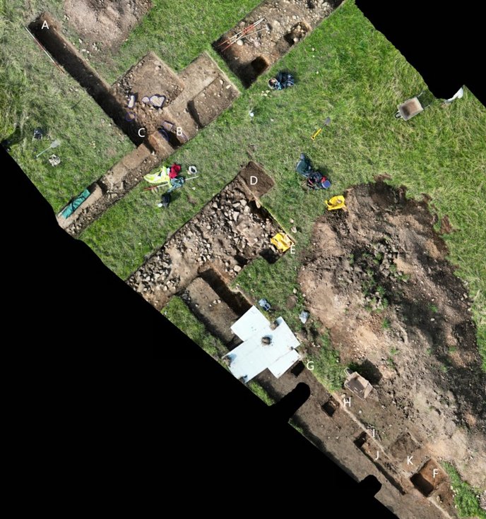
Bill in his absence, had asked for the other end of this sondage (area B on the drone image above) to be look at to see how deep the stone layer was and also what lay underneath. John therefore started to remove the stones here, only to find more large stones. Having revealed a number of large stones grouped together in this sondage, in the afternoon both Peter and John decided to open more of the sondage by removing the layer of mottled clay (area C) to get a clearer view of this area. This revealed more stones as usual below the thin layer of burning (see below) but strange to have a patch where there are no stones. 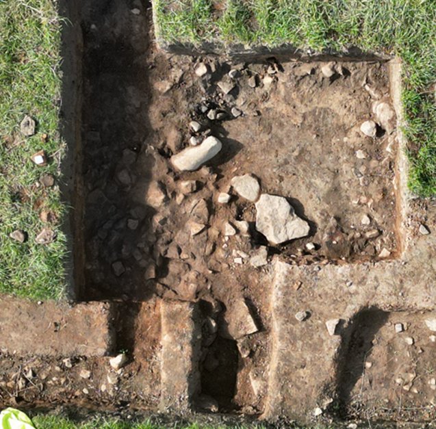
When Martin arrived, he was tasked with extending Trench 3a in the north corner in the northeast direction (area D). This was to investigate what was happening to large patch of sandy clay in relation to the red/black layer and layer of stones in that area. Removing the topsoil revealed the edge of the red/black layer curving round, could this be the edge of a pit cut through the red/black layer. The sandy clay here, though, does not look like ditch fill (work here to be continued next time out).
Chris and Patrick began the work of joining the three new sondages in Trench 3a (S2.3b, S3.3b and S4.3b) (areas G, H and I) so that a section drawing could be completed. An opportunity was also taken to see if the edge of the low resistivity feature could be identified, which sondage S1.3b (area F), suggested could be a pit as it seemed to contain ditch fill. Sondage S4.3b was therefore extended to join the original sondage (S1.3b) (area J) and signs of an edge did seem to became visible. It was therefore decided to investigate this more by removing the top soil to the northeast in this area (area K) to see if more of this edge could be identified (to be continued next time out).
Chris finished the day with his drone survey of Trench 1b and Trench 3b so that areas worked on could be identified (see above).
Tuesday 22nd August
Day 28 – Just three today and with Bill away again, Chris was in charge. Joining him were Peter and later Patrick.
As only three on site, all the work was carried out in Trench 3a. Three new sondages were opened along its northeast edge, each 1.5 m apart, the first being 1.5m from the cut with the cremation in. This was to find the extent of the thin red / black layer and mottled clay layer we have been finding on the northwest side of the trench (towards the centre of the mound). This proved that the red / black layer extended at least as far as the second sondage (S3.3b). 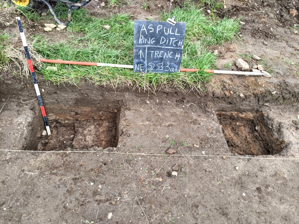 The first sondage (S2.3b) also revealed a thin grey layer at the lower levels which we had not seen before.
Work continued on the east corner of Trench 3a where Steve had previously (Day 27) come across a patch of sandy clay with a couple of flecks of bone in it. It was hoped to find the extent of the red/black layer in this area but work was immediately halted when several more faint traces of possible cremated remains became visible.
Meanwhile Peter worked on the 1m square sondage (S1.3a) that had been opened last time out. After removing a thin layer of small stones, he uncovered a 20cm layer of soft sandy brown material that looked like a close match to ditch fill.
Chris took the opportunity to add more context number labels to both Trenches 1 and 3. He also took more samples of burnt wood which was lying directly under the red layer in Trench 1b.
Thursday 17th August
Day 27 – Great turnout as on today’s team we had Steve, John Needle and Peter joining Chris, Bill and Andy, with Patrick joining later in the morning and Martin in the afternoon.
With still no sign of an edge to the stones on the northwest side of Trench 1b (Sondage 2) Peter with help from Bill drove a 70cm wide slot in the west corner of the sondage in the northwest direction. When stones and the burning layer were still evident, they kept on going. By afternoon when Martin arrived, the slot was now a couple of metres long and showing no sign of an edge. Martin therefore, taking over from Bill, joined Peter in continuing the cut. Eventually at a distance of almost 3 metres, a bare patch of sandy clay began to be revealed (but only on the west side). 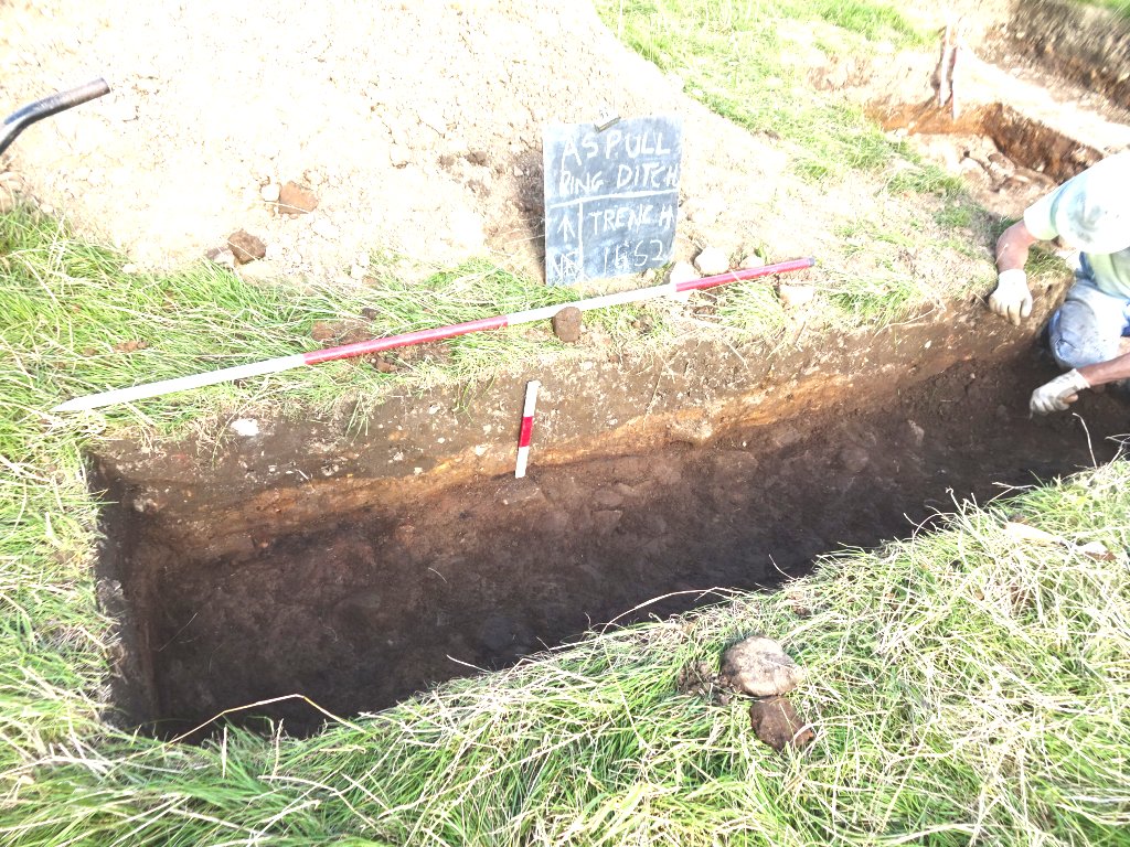
Steve was given the task of exploring a seemingly circular bare patch of soft orange sandy clay in the stony area on the northeast side of Trench 3a. The side wall section was showing the patch came right through the stones up to the plough soil, suggesting it was a cut. However this wasn’t exactly clear as on the northwest side the burnt layer (dark red on black band) seemed to be going over the soft sandy clay before petering out. Also there was no sign of the band on the southeast side (this seemed to have petered out halfway along the southeast section wall. By afternoon Steve had dug quite a deep hole (75cm from the ground surface) without coming across any other layer, just some large stones randomly distributed in it. 
Meanwhile John was given the task of trowelling down the rest of the cut in Trench 3a from which the cremation was discovered. Moving in northwest direction, by afternoon he had reached the scatter of stones in the centre of the centre Trench 3a. This confirmed that there was nothing below the shallow dark grey layer except the soft orange sandy clay.  At the start of the project Bill had been recording contexts producing a register for Trench 1. However with the simplicity of the ditch sections and lack of finds he had the this aspect of the project to lapse (relying solely on the descriptions on his section drawings). We now have a new situation with complex strata and even finds, so Chris has taken up the baton is starting to produce, with the help of Bill section drawings, a comprehensive context register. This will enable us to compare similar contexts in each trench and securely locate our finds in there respective layer.
In Trench 1a Andy was given the task of investigating the southwestern most sondage i.e. Sondage S4. After removing a large round cobble from the soft orange sandy clay that lay under the stones lying in dark grey layer, Andy continued digging down. By afternoon he had expanded sondage to 120cm by 50cm long and had reached a depth of 90cm from the current ground level. Here he had come across the rock-hard surface which he assumed to be the bedrock.  In the section wall there was no sign of any other layer under stones which adds to the suggestion that this is a natural layer.
When Patrick arrived, he was keen to investigate the a metal anomaly which had been detected just outside Trench 3a (about 12.5 metres away from the Profile 1 datum line on the northeast side). This was quite close to the low resistivity patch we had been revealed centred 11m from the Profile 1 datum line. A 1m x 1m sondage was marked out and turf removed to allow careful trowelling, all the time checking with the metre to find out what was causing the detected reading. First a twisted piece of aluminium turned up (presumably from a tractor) followed by a very small unidentifiable fragment which had been giving a signal stronger than its size would suggest. By the end of the day the whole area of the sondage had been trowelled clear of its plough soil, to reveal an orangie brown sub-soil (but no sign of anything relating to the low res signal). 
After finishing his work in Trench 3a, Steve was asked to investigate at the northwest end of Trench 3 which Bill had looked towards the end of last year. This was to see if we could better understand the nature of the natural lying above the bedrock. Last year Bill had discovered a layer of soft orange sandy clay lying under the thick layer of sub-soil. However he wasn’t sure how it related to the bedrock, a section of which had been exposed on the northwest side of the ditch in this trench. Steve was able to show the bedrock lying under the clay layer at a depth of 80cm below current ground level but, with no other layers detected, the suggestion was that the clay layer (once again) is natural. 
Tuesday 15th August
Day26 – Today on site were Steve, Phil, Peter join Bill, Chris and Patrick.
Having updated Phil with our progress, Bill tasked him with exposing more of the stones on the newly exposed southwest side of Sondage 2 in Trench 1b. This confirmed that the stones continued right to the end of the cut. Meanwhile Peter was tasked with expanding the other side of the sondage in both the northeast and southeast direction. This was to see if the edge of the stones detected last time out continued in the same direction. This proved not to be the case as the stones continues in the northeast direction lying under a large patch of burning. Phil and Peter were therefore tasked with extending the trench in the northwest direction to see if the edge of the stones could found. No such luck as more stones emerged on both sides of the trench. 
When Chris first came across the cremation find, he had already cut through the very end of the southeast side before he realised what it was. Today therefore he spent some time sifting through the spoil heap to find the fragments of pot and possible bone he has accidently removed. A difficult task but his patience paid of with the recovery first of some bone and then a fair sized sherd of pot. After bagging these he he undertook the task of expanding the area to the side of the cremation find to see if anything else had been buried in association with it.
Meanwhile Patrick continued to explore the cut in Trench 3a in which the cremation had been found. After trowelling just a few centimetres down he came across the bright orange soft sandy clay we have been seeing in the other trenches (4a, end of 1b, and southwest side of 3a). In fact the section here containing the mottled clay layer above the layer of burning is revealed to be quite shallow but it seems apparent that he cremation was cut into it. This would indicate the original mound must have been much higher.
Bill spent some time working on the southwest side of Trench 3a, cleaning the section and trowelling down into its bright orange soft sandy clay base. The big question is, is this layer the original natural surface or part of the mound’s construction. After digging the base of Trench 4a and end of 1b, Bill was getting more convinced it was natural but staining and black flecks in this area was making him think twice.  Bill ended the day by recording the section helped by peter.
Steve spent his day on the northeast side of Trench 3a uncovering more of the stones he had discovered last time out which seemed to lie in the mottled clay layer with a burnt layer on top. The question we needed to resolve was how this related to the burnt layer lying below the mottled clay. As he progressed it became clear that in fact the two layers were the same as the tell-tale dark red and black bank could be seen rising sharply up to the level of the newly exposed stones. It was decided to expand the trench in the southeast direction by another half metre to see if we could find the extent of the stones in that direction. 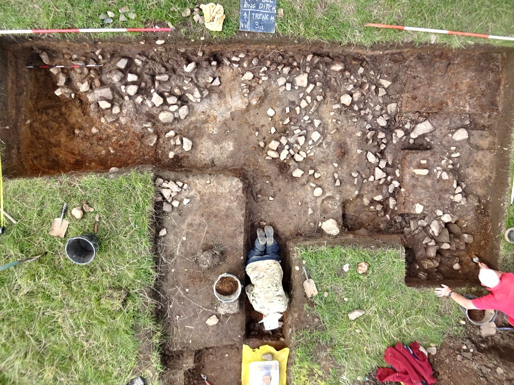
This revealed more stones but on the east corner of the trench there was patch of soft sandy clay. Carefully trowelling it Steve came across a couple of flecks of what appear to be bone fragments. The were no signs of burning or a enclosing vessel but Steve carefully covered the area for closer examination next time out. 
Steve finished the day by working on the northwest side of the trench uncovering more of the stone layer. The stones are more intense here – could we be getting closer to the core of the monument? 
Friday 11th August
Being aware of our legal obligation to inform the coroner of our find of human remains, Patrick took the advice from the County Archaeologist, Ian Miller, and phoned the coroner’s office. They advised that, in the first instance, he should inform the police. This he duly did and there followed in the morning several hours of slightly confused police officers, from various departments, phoning him up. This eventually resulted in him being informed mid afternoon that a detective and a Crime Scene Investigator (a CSI) would be attending the site and he was to meet them there.
Initially, the detective constable took pictures of our as-yet unexcavated find with her phone and sent them to the relevant department. Apparently being of insufficient quality, the CSI took pictures with a much more sophisticated camera and sent them off. Several more confused conversations took place between the officers on the scene and their departments. It was clear that this was an unusual occurrence for them, though the two officers on the scene did their level best. Eventually they seemed to understand what Patrick was saying, with the CSI noting ‘I don’t think we’re going to solve this one’.
After two hours wait (fortunately a lovely sunny afternoon – far worse places to be stuck) two small plastic boxes of tiny bone fragments (collected by Chris and Patrick during the preliminary investigation) were taken by order of the coroner. Patrick was assured that we would get them back and we now currently await word of the coroner’s verdict but have no idea how long it will take.
Thursday 10th August
Day25 – Busy day today with Manchester Young Archaeology Club (YAC) joining us for a days training. Starting the day, the WAS team consisted of Bill, Chris, Steve, Andy and even Patrick (with Martin joining late afternoon). The YAC supervisors included Carolanne King, Clare Pye and Kerry Beeston, all led by our own Ian Trumble (who now runs the club). The YAC team consisted of 10 children and two parents.
Bill started by giving the visitors a guided tour of the site (not easy with so many to negotiate the deep trenches and spoil heaps). Then the group was split into two with one half given the job of trowelling off the top soil in Trench 3 while the other half given task of sieving the spoil from Trench 3a. 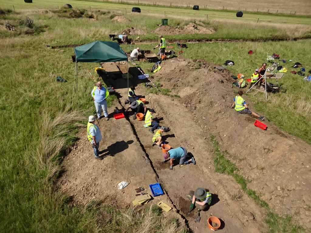 Both activities produced plenty of finds (albeit 19th century or later) but were of great interest to the children and at the end of the day they had a great experience of the archaeological process.
Meanwhile work continued in our other trenches. In Trench 3a Steve set about extending the northeast side by over a metre. This was to investigate the extent of the large consolidated area of stones lying beneath the thin layer of burning. Soon after taking off the top soil however he came across stones lying in the mottled sandy clay. This seemed to form a circular shape surrounding a patch of soft orange sandy clay, so Chris join him to help with the careful excavation (we are taking much more care now realising we could at any time come across another cremation burial). There was some evidence of burning so a section was cut into the mottled clay to see how this related to the lower burning layer (this didn’t seem to be the case therefore had we got two burning events?). 
More progress was also made in the Sondage 2 in Trench 1b where Andy was tasked widening it in the southwest direction. With help from Martin when he arrived, he was able to prove that we had not reached the edge of the stones in the northwest direction.  However it did seem to show an edge facing north (but, as in Trench 3a we seem to have an underlying layer of soft orange sandy clay.
Carolanne stayed behind after the children had gone to have a look at the variety of stones we have been uncovering both this year and last. She has a particular expertise having work on the Grange Farm site at Hyde on the east side of Manchester. This prehistoric site had revealed a variety of worked stones particularly hammer stones i.e. rounded stones that can be easily held in the hand which have distinctive pecking marks on one side. Carolanne couldn’t find a specific example amongst our collection but she did identify a stone that had been cracked by heating and rapid cooling (these are normally associated with ‘burnt mound’ sites which ours iclearly isn’t as these are invariably associated with a water supply).
Not clay but a silty sand.
Carolanne also had a good look at the soft mottled sandy clay layer and thin band of dark red and black overlying the stones in Trenches 1a, 1b and 3a. She thought the mottled sandy clay resulted from turfs laid when the mound was built. When she examined the material, she corrected our description – this was not clay but a silty sand, the test being that it cannot for a ball when when rolled and stains the skin when rubbed between the fingers. Significantly this also applies to the dark red band which we have been assuming was the result of heat effecting the iron-rich sandstone. She agrees that there is clear evidence of burning but what caused the dark red band remains a mystery.
(A useful guide to soil descriptions can be found in the Poulton Site Manual.)
Tuesday 8th August
Day24 – On site to day with Bill and Chris were Peter, Steve, John Smalley and Natasha, with Patrick joining later in the morning.
Very exciting day to today as we discovered our first in situ find i.e. the remains of what appears to be a cremation urn with fragments of bone inside. This is great news as it confirms that our site to be a funerary monument. It’s location though, has come as a surprise as, although it is something we expected to find sooner or later, it’s some distance away from the area of stony centre of the monument.  We knew we needed to extend Trench 3a to establish the extent of the stony area so Steve was tasked with extending it on the southwest side. This he did by digging out another half metre confirming that we had reached the end of the stony area in this direction, although some more stony scatter and the depth of underlying soft sandy clay has yet to be established).
  Chris however wanted to check out the extent of the burning layer in the southeast direction (his coring had suggested it went some distance that way). Bill suggested he cut a 60cm slot 3m long down the northeast side of the original cut of Trench 3a. With Peter’s help they started to trowel down to the soft mottled clay layer, Peter at the northwest end and Chris at the other. Chris almost immediately uncovered a area of burning lying directly under the top soil and closer inspection reveal small fragments of bone. Careful trowelling revealed a circular form of orange clay within the area of burning which developed into the unmistakable shape shape of a pot. Although fragile, its external surface could be clearly identified. Cremation urns are usually upside down but there seemed to be a flat on its circular form suggesting a base which could mean the pot is lying on its side. Trowelling down on the southeast side of the vessel, Chis revealed that only a few centimetres of it remain, the rest obviously destroyed by ploughing. Peter’s trowelling from the northwest end of the cut reveal the tell tale sign of the burning layer (we’d seen in the rest of the trench) lying just a few centimetres below the soft mottled clay layer.
 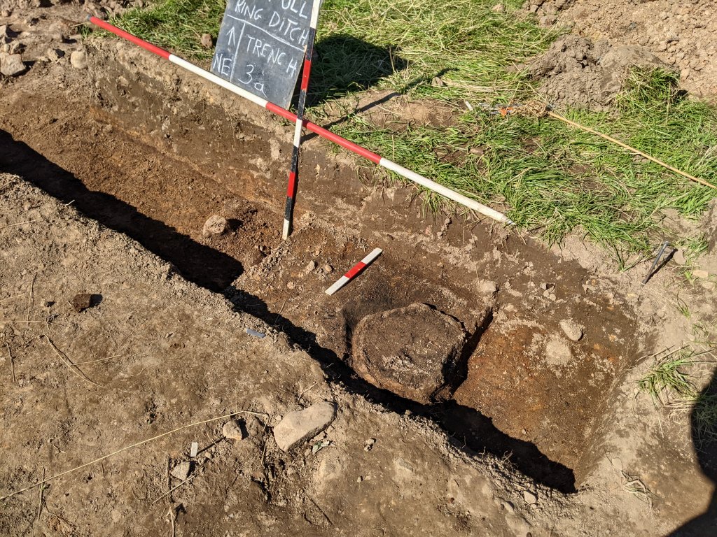 Significantly the pot seems to be lying in a cut in the soft mottled clay layer which strongly suggests it was later insertion. This was quite a lucky find which suggests there could well be many more so we will need to be more vigilant in future. Patrick has reported the find to Ian Miller who advises us that, as the bones are most likely human, the best practice is to inform the coroner and if we want to take samples we will have to obtain a licence from the Ministry of Justice.
Meanwhile work continued on other areas e.g. john was asked to extend the sondage in Trench 1b which Patrick had worked on last time out. This was to see if we had reached the edge of the stones in the northwest direction which seemed to be the case. John showed that this was not the case as his 60cm extension revealed more stones. However these soon seemed to peter out to reveal and underlying soft sandy clay. The burning layer was still evident so more work needed in this area.
Natasha was given the task of cleaning the sections in Trenches 3a and 1b in preparation for recording. The northwest section of Trench 3a was particularly interesting as showed the mottled sandy clay having diagonal bands of light and dark orange. This represents a peculiar method of deposition but one explanation could relate to the theory that the soft sandy clay is the result of degraded sandstone i.e. the diagonal bands seen in the section could have originated as stones.  When examined, the southeast section of Trench 1b also demonstrated similar diagonal orange banding in roughly the same location. However, moving further to the southwest, the this banding became more horizontal with streaks of dark material separating them. Eventually we reach the thick layer of light grey sandy clay but that too was showing shallow diagonal banding.
  Bill meantime had been exploring the end of Trench 1b where he was thinking he had reached the natural ground surface. He was able to confirm that this surface did extend under the stony scatter in this area albeit separated by a layer of soft orange sandy clay. As reported last visit, the light grey soft sandy clay and dark grey layer that the stones are embedded in, do not reach the end of the trench on this side. Both seemed to be truncated by a cut filled with sub-soil. As this does not occur on the other side, it must be assumed to represent a local pit.
Thursday 3rd August
Day23 – Better turnout today with Peter joining Bill with Chris with Patrick arriving just before lunch. We also had another visit from John Trippier who was intrigued with what we had uncovered, but quite happy with our interpretation that his is a multiperiod site (typical of the late Neolithic early Bronze Age period).
While Chris and Peter busied themselves cleaning the stony surface in Trench 3a (Chris on the newly exposed area and Peter on the rest), Bill started work on the southwest end of Trench 1b. Previously John Smalley had shown that the scatter of stones on this side of the trench petered out, leaving just a layer of a dark grey sandy clay lying under a thick layer of lighter grey sandy clay. To investigate this further, Bill needed to extended the trench in the southwest direction (this took some time as the trench was now over 60cm deep but managed to extend it another 55cm). Trowelling the bottom of the trench revealed the layer of soft bright orange sandy clay, John had come across, lying under the dark grey sandy clay. The southeast side the section revealed that the dark grey sandy clay ended abruptly with the overlying lighter grey sandy clay merging into what appeared to be a deep layer of subsoil.  Cutting into the bright orange layer Bill found it hard going as, although soft, the sandy clay was full of stone pebbles/cobbles (some quite large). This was reminiscent of the layer Bill had uncovered in the Trench 4a which, in the end, had been convinced was natural. Were we seeing the natural surface here as well? Contrary to what he’d seen in the southeast section, Bill noticed that the dark grey sandy clay in the northwest section, seemed to continue all the way to the edge of the trench (but again the overlying lighter grey sandy clay merging into what appeared to be subsoil).
  Whatever is going on here, it is clear we have reached the end of the stony area on the southwest side.
When Patrick arrived, he set to expanding the second sondage in Trench 1b in the northwest direction (removing the overlying layer of orange sandy clay) with the aim of establishing the extent of the stones on that side. It was expected that we would probably have to extend the trench in that direction before finding the edge of the stony area. However just before he reached the edge of the trench, Patrick discovered what appeared to be the end of the stones (we will probably need to extend the trench anyway to confirm this).  Meanwhile Chris and Peter had been doing a great job on the stones in Trench 3a. Peter had revealed that the stones in central area were lying on top of a layer of soft sandy clay, whereas the stones on the southwest end seemed to be more deeply embedded. Chris was also finding that the stones on the northeast side were similarly embedded. They stretched further out from the centre but seemed to peter out just before the end of the trench. In fact what we seem to have are two substantial areas of embedded stones, suggesting perhaps two separate cairns with just a scatter in between.
 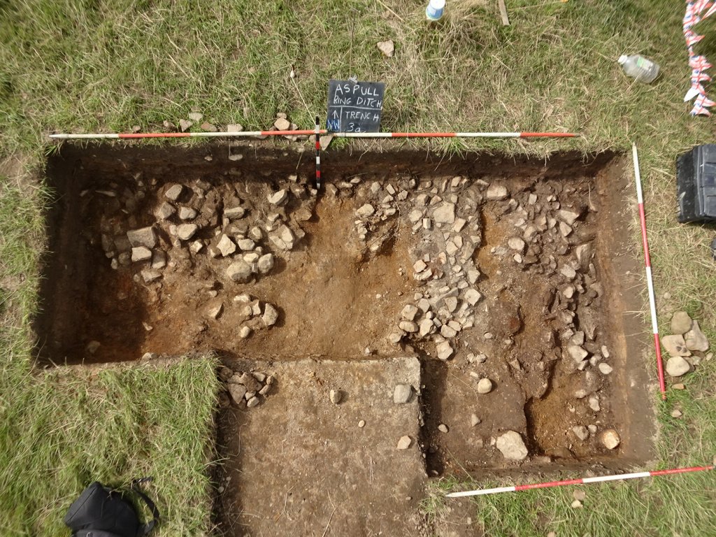 All across the trench though there was evidence of burning, represented by a thin band of maroon-coloured material on top of a thin layer of black (source of much charcoal).
  Bill noted that, apart from a small area in Trench 1a (where they are directly under the plough soil), the stony layer was sealed in all areas below a layer of sandy clay. The stones in Trench 1a and in the centre of Trench 3a lay on to top a layer of soft sandy clay. This, together with the burning layer, clearly demonstrated a sequence of deposition – however without finds (apart from the charcoal) it’s going to be difficult to establish a time sequence for this activity.
Tuesday 1st August
Day22 – Only Bill and Chris braved the drizzly rain today – although wet, it wasn’t sufficient to stop them carrying out some useful work.
First job was to expand Trench 3a in the north corner (in effect to square it off). The top soil was quickly removed to reveal a really nice pattern of mottled clay (which can also be clearly seen in the northeast section wall). This layer clearly seals the stone layer.  At this point Bill left Chris to get on with removing this clay layer as Bill needed to finish the work started by John and Phil last time out on the two sondages on the inside of Trench 4. This was to check the surface revealed at the bottom of the second sondage to see if there was a harder surface below it (which seemed to be the case when probed). He therefore expanded the trench (now referred to as Trench 4a) another 0.6m towards the first sondage. This revealed more of the bright orange layer previously uncovered. However trowelling the surface revealed that there were more stones in it that previously thought. In fact cutting a 0.6m sondage in the southwest side proved quite difficult and Bill had to resort to using the mattock to get anywhere. After an hour he’d only managed to get down another 20cm with no sign of another surface.
  The probe was still reaching 20cm into it – however when Bill checked the surface in the first sondage with the probe he was able to get a similar result. This seem to confirm that the bright orange surface in both trenches was in fact the original ground surface.
Meanwhile Chris had painstakingly removed the mottled clay to reveal more stones, this time quite large ones lying in dark grey loamy clay. In fact he was able to chase the layer of stones further away from the centre into the area previously thought to be devoid of stone. Lying just above them was a layer of burning evidenced by patches of charcoal (some up to 1.5cm in length). The section revealed a thin layer of dark red laying on top of a thin layer of black from where the charcoal was coming from.  The size of the blocks in this area suggested something different from the other areas uncovered so far (could we be nearing the core of the mound?).
Tuesday 25th July
Day21 – What a great turnout – joining Bill and Chris today were Andy, Steve, John Smalley, Peter, Phil, John Needle, Ashley and partner Chris Gibbons (with Patrick arriving late morning).
Ashley and Chris G were immediately set with the task of expanding Trench 3a another half metre on the northeast side to get an idea of the extent of the stony scatter (which Steve had revealed last time out). At the same time Steve was set to extend the trench on the other side by a metre (i.e. southwest side) to explore the extent of the distinctive boundary between the stony area and the mottled orange clay he had previously exposed last. With John Needle’s help the top soil and underlying clay was quickly removed revealing more stones, which proved the that boundary did not extended in that direction. However towards the end of the trench the stones began to disappear with the mottled orange clay returning to fill the south corner.
On Ashley and Chris’s side, the half metre extension failed to produce any more stones so they increased the extension by another half metre. This revealing a large area of mottled orange clay with just the odd (largish) stone poking through, so the trench was extended by 0.9m but this time towards the centre (i.e. northwest). This produced a scatter of largish stones within the mottled orange clay.  Removing the largish stones revealed a large patch of charcoal indicating an area of burning, the side walls of the trench highlighting the depth of the mottled orange clay in this area.
  Meanwhile Andy continued expanding the sondage in Trench 1a at the edge of the consolidated stony area on the northwest side, while Peter continued with the similar cut on the opposite side. Both were eventually happy that they had found a hard layer that perhaps represented the original ground surface.
Phil was given the task of re-trowelling the area also in Trench 1a from the edge of the stony scatter to the area where Patrick had been working last time and beyond.  This seem to confirm a sudden step in the hard natural ground but with a slight concave (i.e. bowl) shape to it. When Patrick arrived, by widening the cut he revealed that the the step was in deed semi-bowl shaped (one explanation could be that it had been produced by a tree throw).
  Bill, with help from Andy, was able to record the profile so that, with the help of his new measuring device, he could attempt to draw the section. In fact it seems we have another layer of sandy clay, harder and slightly stony, lying under the soft sandy clay (but not as hard as the base layer). In the area of the semi-bowl shape, the section revealed a small area of sub-soil suggesting a pit cut into the soft sandy layer (as usual though, no finds).
On the southeast side of Trench 1a, Chris D marked out two slots, the first in the south corner, the other 2m further along. This was to investigate the depth and character of the stony area in this trench. While he investigated the first, Peter was set to investigated the second. Digging down, they both quickly revealed that the stones in this area represented only a thin layer resting on soft grey coloured sandy clay.
John S meanwhile was given the task of excavating the very end of Trench 1b where the stones seemed to peter out. Removing another 10-20cm revealed a soft dark grey sandy clay with only the odd random stone, below which was another layer, this time soft bright orange clay. Probing revealed that this soft sandy clay went down perhaps another 75cm suggesting the mound to be quite deep at this point. As we weren’t sure what we were looking for, it was decided not to dig this out any further for now. Instead John was asked to have a look at reopening the inside edge of Trench 4 as we know we had the original ground surface there and this was the direction Trench 1b was heading. Helped by Phil, John therefore opened up a small 70cm x 100cm sondage on the north corner of the now filled in Trench 4 and soon found the natural ground surface lying under a good depth of plough soil and a thick layer of sub-soil (as had been discovered previously). The natural ground surface was hard, stony and bright orange coloured (but the stones were not the glacial pebbles we see in Trench 1 and 5). To see how this developed it was decided to put in a similar sondage 2m away towards the centre. The orange clay layer appeared again at a similar depth but this time it seemed to be softer and with not so much stones. Probing suggested the hard surface was perhaps another 15cm below it.
John N in the meantime had been given the important job of cutting the grass around the trenches so that they could be clearly seen from Chris’s drone. When finished he joined Steve helping to clean the stony area in Trench 3a ready to be photographed. As revealed before, there was clear distinction between the grey stony area and the mottled orange sandy clay further out from the centre. 
Experiment
At the start of the day John S had described how he had taken a piece of the orange coloured sandstone (typical of the bedrock here) and subjected one half of it to intense heat (using a blow torch). This had turned a maroon red very similar to the colour of the stones in the area of suspected burning in Trenches 1a and 1b. This seem to indicate that he reddened stone in this area was in fact as a result of intense heat (as opposed to the possibility that it could be just the iron rich content of the stone).
Thursday 20th July
Day20 – Good turnout with Andy, Chris, Steve, and John Needle joining Bill with Patrick joining in the late morning. Also joining the team today was Natasha Lancaster a student at Winstanley College.
While Bill gave Natasha an introduction to the site, Steve got stuck in removing the baulks in Trench 3a. Andy was given the task of continuing the where Ian had left off at the edge of the consolidated stony area in Trench 1a (on the northwest side) while Chris investigated the same area on the other side of the trench. This was to see if the natural ground surface could be found below the soft sandy clay layers. After having a go with Chris’s metal detector, Natasha was given the job of re-troweling the sondages in Trench 1b where burning was evident (i.e. rich in charcoal). The dark red iron rich surface was soon revealed in the northeast sondage and the consolidated stones in the adjacent sondage.  Meanwhile John was keen to get stuck in so Bill asked him to look at Trench 6. This was to widen the area at top edge of the ditch on the east side to confirm the direction of travel of the ditch.
After Steve had removed the baulks in Trench 3a, the full extent of the distinctive boundary between the stony area and mottled orange clay was exposed. This seemed to confirm we that we might have the southeast boundary of the stony layer (sweeping around towards Trench 1b) – with just a small scatter in the east corner .  He was asked therefore to extend the trench by half a meter to the northeast (on the left side in the above photo) to see if the lack of stones continued which would in deed suggest we had reached the edge of this feature. However this revealed more stones extending across the whole area of his extension revealing that we had not reached the limit of the stony area. Steve was therefore extended this part of the trench another meter in the southeast direction (i.e. away from the centre). This produced some stones but not consolidated as before (more like the scatter we’d seen in Trench 1a).
Patrick, on arriving, joined Andy and Chris searching for the natural ground in Trench 1a, this time at the edge of the stony scatter on the northwest side of the trench.  All three were struggling with this as there seemed to be a lower layer of harder sandy clay – but not the usual hard compacted clay (with small pebbles) we have come to associate with the natural ground surface in this area. However a hard bottom was eventually reached in each sondage but, as this was deeper than adjacent areas, there seemed to be a suggestion of terracing (whether natural or manmade has yet to be determined). At some point we will have to cut into the consolidated stony layer to understand its structure.
Over the weeks we have been making the odd find small pieces of flint mainly from our sieving efforts. However on recent excavations of the central mound, more and more pieces have come to light, very often just lying on the spoil heaps. None can be identified as tools and it isn’t certain whether they are debitage from tool production or general debris from glacial activity. Whichever, they have certainly travelled some distance as there is no natural source in this part of the country.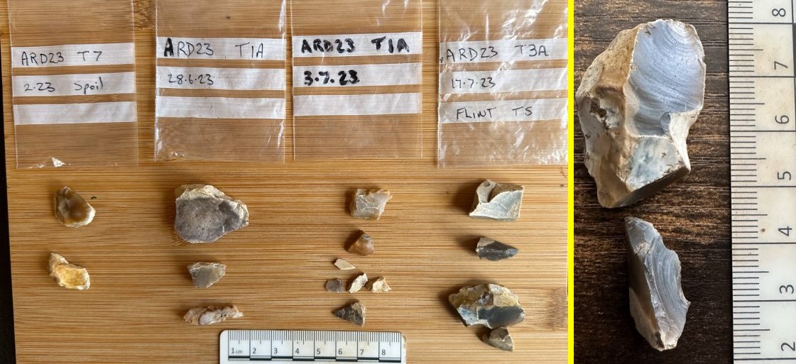
Monday 17th July
Day19 – Bill, back from his hols, was joined today by Andy, Steve, Chris and Patrick with Martin and Ian Trumble joining in the afternoon.
Bill quickly got up to speed with developments (not quick enough for Steve who was raring to get stuck in). Bill’s main task today was to measure all the latest trenches in. This would include using his latest digital measuring device (which he had added a compliant stick to give him a better chance of holding it steady). Before he could take the measurements though, the trenches needed dewatering which task he gave to Andy (helped by Chris).
To get Steve going it was decided to open up a sondage at the end of the new trench, Trench3a (in the northeast corner) to see if the stone layer could be picked up in that direction. Steve quickly discovered the orange layer laying just below the plough soil and not far below the expected stones but not all across the 80cm x 80cm pit, so another sondage was opened further down (leaving a small baulk). This time little sign of any stones, just a few random ones so a couple more sondages were opened adjacent to the first two.  This time the pit closest to the end was full of stones but in the other, there were some stones on the northwest side but mainly orange sandy clay with a distinct edge between the two (are we seeing here, the extent of the stony layer in this direction?). It was also noted that the stones here were lying under the grey sandy clay, whereas the sandy clay in the rest of the exposed area was the mottled orange as seen in the other trenches.
Meanwhile Chris continued exposing the stony layer at the end of Trench 1b showing that the stones continued right to the very end. The section wall in this area clearly shows that the overlying sandy clay is a light grey colour instead of the mottled orange colour in the rest of the trench (there was also some banding suggesting different construction events).  In the mean time Andy finished cleaning out the sondage on the northeast side of the original Trench 1 in preparation for Bill’s attempt at measuring the profile on that side of the trench using the Moasure device. Bill’s idea was to take a readings on that side up to the consolidated stony layer. Then switch over to the other side to take readings along the rest of the trenches taking in all the sondages on that side. Once again he struggled to get a good set of readings but eventually got a good result from both sides once he got the hang of using the flexible stick he’d added.
In the afternoon, when Martin and Ian arrived, Bill gave Ian a tour of the site while Martin got stuck into clearing the rest of the collapsed material out of the Trench 1 ditch (helped later by Steve). Meanwhile Ian was keen to join the activities so Bill asked him to look at the area at the edge of the consolidated stony area in Trench 1a where there appeared to be a patch of soft sandy clay (on the north west side). Steve had previously thought he had hit a layer of hard clay but this proved not to be the case as Ian was able to trowel down below this level.
The day had started quite wet but by the late afternoon was sunny and quite pleasant (shame we had to leave).
Saturday 15th July
Patrick took an opportunity to get get Nick the farmer to open up a new trench with his machine. It was agreed at the project meeting in June that we would continue extending Trench 1 towards the centre of the mound (and beyond if necessary), and also extend Trench 3 (which is at 90° to it) to meet up up with it forming an ‘L’ shape. On the ground however Bill expressed doubts about this as the overburden was deep in Trench 3 and is a long way from the new trenches (always better to work from the known to the unknown). Chris therefore suggested a compromise i.e. working the other way from the new trenches towards Trench 3. The spoil heap from Trench 3 would still need to be removed so on the day Patrick took the initiative when Nick was available to get him to remove it.  Once dealt with, the top spoil was then removed from Trench 3 all the way up to Trench 1b (well almost, a 2m gap was left for access each sector).
Thursday 13th July
Day18 – Just four today, Chris, Steve, John Smalley and Patrick.
Chris and Patrick completed their respective sections in the 4m extension showing the stony layer with black flecks possible burning. John and Steve opened up new sondages in the 2m new extension.
Steve and John also showed that stones existed in the latest 2m extension so extended by a further 2m. Small sondages in this new area showed stones again, although they looked larger and not flat, so the decision was made after lunch to join all the separate sondages together in a narrow strip to determine if the compact stone area has an edge.  A change in the nature of the soil was also detected. To the southwest end of the trench the material above the stones was grey, to the northeast it was still the orange material we had been following for the last two week. There was a clear point where the orange layer and compacts stones stopped.
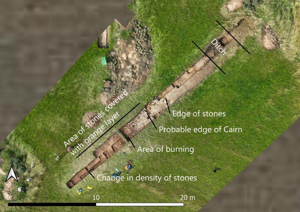
Wednesday 12th July
Day17 – Another good turnout, joining Chris were Steve, John Smalley, Phil and Patrick, and also, for the first time digging, Ashley Brogan and partner Chris Gibbons.
11:00am start today due to the weather and while Ashley and Chris were given a tour of the site, a strategy was devised for the next few days digging. The new trench (Trench 1b) was split so that half of the orange layer would be preserved on the northwest side. Working only on the southeast side of the extension, sondages were cut along the 4m length so that any termination of the stones could be determined. Section views were create along and across the area. The idea was that these sondages could be joined up at a later date when the area covered by the compact stones had been determined. 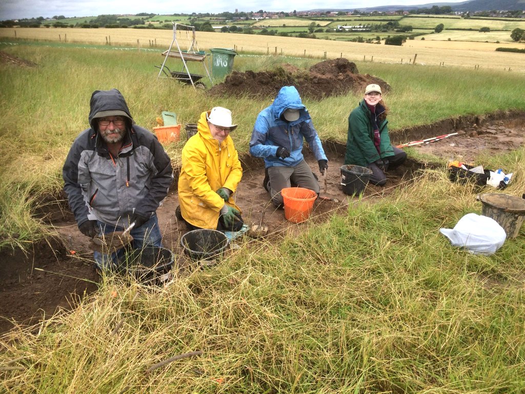 As Ashley and Chris removed the orange layer down to just above the stones in the sondages, a large area of possible burning appeared which matched what had been found not far away at the end of Trench 1a the previous week. Patrick and Chris D opened up smaller areas further along the trench. Chris D identified the compact stone layer at the end of the 4m extension so Steve and John extended the trench a further 2m by de-turfing (but this time only half the width of the trench). Sections in all the sondages showed that the black/orange/grey layers we had been excavating run diagonally across the area.
Phil, meanwhile, re-cleaned out an area of Trench1a which had been rained on. 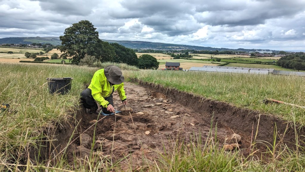 He highlighted a thin red line, which may be iron pan, running along the section between the orange layer and the stones.
 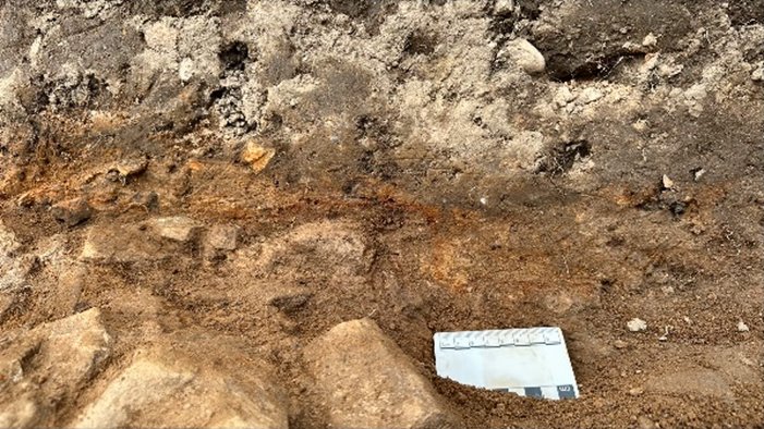 A few days later it was thought another thin red line could be seen further up the trench (further inspection suggests this was degraded iron rich sandstone rather than iron pan).
Wednesday 5th July
Day16 – Good turnout today with Steve, Phil, Peter, Patrick and joining Chris. Also new starter John Ashcroft joined mid-morning for a few hours and had a go at sieving.
Work continued cleaning Trench1a in the morning. In the afternoon a further 4m length (Trench 1b) was de-turfed (leaving a small baulk) and taken down to the top of the orange layer that sits above the stones. 
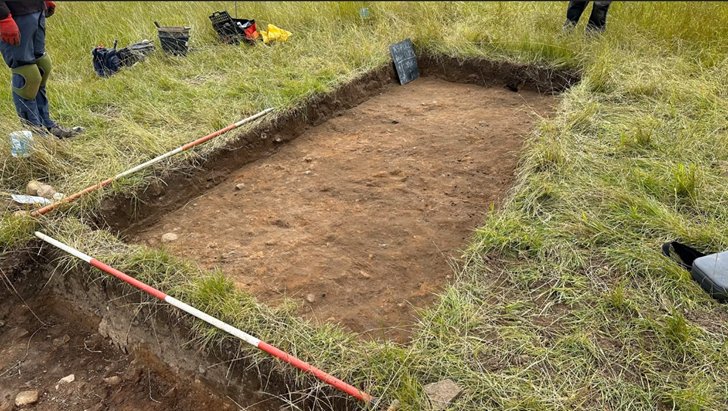 The day finish early due to the WAS meeting in the evening
Monday 3rd July
Day15 – Just three today, joining Chris were Steve and Patrick.
The morning cancelled due to rain but they managed a couple of hours in the afternoon cleaning the remaining orange layer above the stones in of Trench1a.
Wednesday 28th June
Day14 – With Bill on his hols, Chris took charge for the next couple of weeks. Joining him today were Steve, John Smalley, Peter, Martin and Patrick.
Trench 1a was extended by another 4m towards the centre of the mound by removing the top soil (by hand – mainly Steve). In this area the under the top soil was a thin layer of orange sandy clay (not seen previously). Trowelling down through this layer they reveal more of the compacted stony layer. It was clear that the stony layer extended the full length of the newly opened area. In the final meter there was a large patch of black/red/white (mainly on the southeast side), probably on top of more stones that is possibly an area of burning.
John also found amongst the stones in this area perhaps what might be a small stone axe.
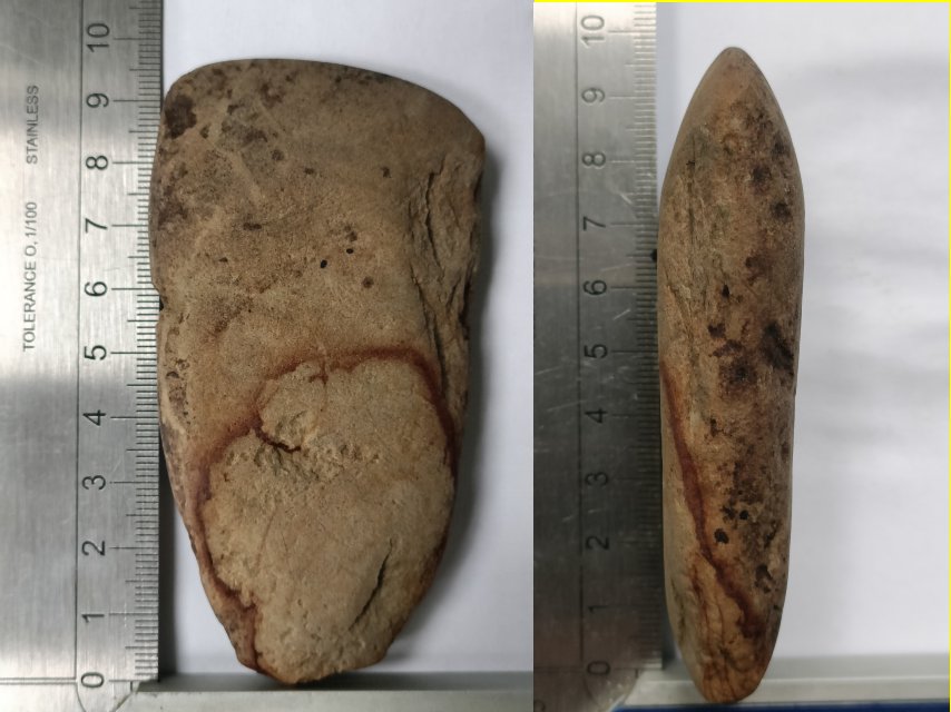 He sent images to the Liverpool Museum finds officer but learned that she was on holiday for another two weeks so have to be patient for the result. In the meantime he looked up information on axes of that size. In particular, there have been many with those dimensions ~ 10 x 5 cm – found on Orkney (from various stone types including igneous rock and sedimentary sandstone). In addition, it appears whilst they were not used as functional implements per se, they were often found in funeral contexts as offerings
As mentioned before, the northwest wall section of the ditch in Trench 1 had collapsed over winter partially filling it in, so Martin had a go at clearing it out. He managed to expose 1m of the stone floor on the northeast end of it. A large piece of burnt wood was found and bagged.
Monday 26th June
Day13 – Joining Bill on site today were Chris, Steve and new recruit Phil Livesey with Patrick joining in the afternoon. All our work today was concentrated on Trench 1a which started by recording where we had got to with last weeks efforts. We than removed the rest of the turf from the extension created last time out.  While Steve was give the task of trowelling this area, Phil was asked to look at the cut that Andy and been working on last week on the NW side of the trench. This was to continue extending it into the stony area and making sure he had the hard natural surface. Meanwhile Chris was looking at a soft patch on the opposite side of the trench which was much closer to the consolidated stony area. This was to be able to examine how deep the stony area was by see what was underneath it. Bill took advantage of the fact that Chris wasn’t working in Trench 5 to take some measurements using the new measuring device. Phil made good progress with the cut he was working on but was unsure whether he had the hard natural as there were large angled stones in it which are not expected in the glacial deposit. When Patrick arrived he too was not convinced, although we had a hard surface, when compared with the obvious natural in the ditch area, it was not the same.
  When Bill put the corer in, it wasn’t that difficult to get through and showed the bedrock to be about 0.5 below the surface. Chris too was have a problem in the area he was looking at because the soft sandy clay seemed to be going under the consolidated stony area (this would not normally be expected of a purpose built structure but maybe in our case it is).
  Meanwhile Steve had completed exposing more of the consolidated stony area but was finding cavities in it. One was certainly a tree root but others weren’t. When he examined the area in front of the consolidated stony area he also found the soft sandy clay going under the stones. However he did reach what he thought was the natural hard surface about 20cm below the stony surface. This is obviously a significant feature but what it represent is yet to be discovered, obviously needs more investigation.
  We will continue extending the the trench towards the centre until we find the end of it. We will then take a 90º branch towards Trench 3 – rather than come up from Trench 3 as originally planned as this is perceived to be quickest way of establishing the extent of the feature (always better to go from the known to the unknown).
In the afternoon Jim Meehan brought Derek Winstanley and his partner ? to have a look at our site (Derek although a well renown local historian, now lives in the States) . Bill gave them a tour and all showed great interest. Later the Nick’s wife, her mother and two daughters came to pay a visit taken around the site by Chris (great to see the family showing interest in our work).
Wednesday 21st June
Day 12 – another good turnout, joining Bill and Chris were Andy, John Smalley, Peter and later John Needle (with Patrick and Martin joining the afternoon).
Straight away Andy set off with the task of extending the cut in Trench 1a (the idea being to chase the perceived natural ground surface towards the stony area) while John and Peter carried on clearing the stony area in this trench to check to see if it continued all across it.
Meanwhile Bill had brought along his new measuring device for another attempt to get good readings. Since last week he had been able to get a better understanding of how it worked and had been looking to see if there was something he could do to improve his chances of getting a good result. The main issue was its instability when held on an uneven surface (the device having a flat base). Bill had rigged up a mount for it which gave it a three-point connection with the surface to be measured. He was keen therefore to test it on the difficult Trench 7 (wrapped in a small finds bag to protect it from the mud).  Before he could do that however, the ditch bottom had to be cleared of water and sludge and Bill got extra help with this messy job when John N and Martin arrived. The first measurement Bill attempted was the ground profile stretching from the section wall of Trench 7, along the interconnecting trench and through into Trench 6a (which Steve had done a great job clearing it out the week before).
After stuttering start with this attempts producing various errors (reported to him as ‘putting the device down too hard’, ‘not travelling fast enough’, ‘hesitation’ and ‘twisting to fast’) Bill eventually managed to get a full reading.
His next attempted was to get three profiles of the terminal end in Trench 7 (i.e. bottom, mid-section and top). Bill had learned that by using layers with a base line datum, he could combine all three in the same file, thus creating a 3D model.
Again it took a little time for Bill to get going (to the frustration of the bemused onlookers), but once he’d gained confidence in his placement technique, it didn’t take him long to complete the task (even using a ‘trace’ mode on the top section which automatically records the machines location every 10cm). The resultant model, all agreed was quite impressive and Bill was confident he would be able to easily download the data and incorporate it into his plan drawings.  In fact when he later did this, the profile across he had obtained across from Trench 7 to Trench 6a proved to be very close to the the profile obtained the traditional way. This was very encouraging giving us confidence to be able to use the device (with its three-footed mount) for all our recordings in future (as mentioned before we would still need to rely on tapes for setting out of datums etc.).
In the afternoon we had a visit from Kevin ?, who is a digger with the Wyre Archaeology Society and his partner Sian. She is a geologist so it was interesting to hear her thoughts on the ditch structure we are presented with (i.e. she thought the hole in Trench 3 which lies outside the ditch, was manmade, contrary to others who have see it). Kevin originally came from Aspull so has a particular interest in our site (he fought the council to stop them using the Kirkless site as a landfill but lost). Both Kevin and Sian said they were very impressed with our site and Bill said their group was trying to arrange a visit later in in the summer.
By late afternoon the whole 2m southwest section of Trench 1a had been cleared showing the stony area stretched across it.  Andy had also reached it with his cut. This demonstrated that stones in this area were not part any structure but seemed to be just randomly distributed amongst the soft sandy clay.
  Right at the very end of the trench however, john had revealed an area of stone that was much more consolidated. It was decided therefore to extend the trench in this area towards the centre. In time available we decided to make it just 40cm long by 1m wide. This revealed more of the consolidated stonework giving us some excitement that this might well be the remnant of the actual original mound.
  We decided not to ask Nick to remove more topsoil as work from now on in this area would need more careful attention.
Wednesday 14th June
Day 11 – good turnout with Steve, John Smalley and Peter joining Bill and Chris. While John continued the work cleaning the newly exposed section in Trench 1a, Peter began removing the rest of the top soil and any subsoil from the trench Nick had extended. Meanwhile Steve carried on his work in Trench 6a finishing off the east side wall while Bill cleared out the bottom of Trench 6. This was in preparation for this use of his new measuring device which had arrived the previous day.
Moasure 1 measuring device.  Recording our trenches using string lines, tapes, plumb bob etc., is very tedious, time consuming and needs two people. The information gathered on tracing paper has then to be interpreted and transferred into the CAD drawing which again takes time. We’ve looked at other methods such as Chris’s iPhone LiDAR function which can produce a 3D model of our structures, but the resolution of the resultant sections are not sufficient for use in the report. We have a laser measuring device which proved very useful in our Parish Church Tower interior survey. However it’s not so good for recording outdoor trench sections (particularly difficult in strong sunlight). A total station, as used by professionals, or GPS would be great but well outside our budget. This new device however, is affordable and is offered on a 30 day trial, so was thought worth a try. Its operation is solely dependant on movement (acceleration, deceleration) so no tapes or strings and all measurements are logged and transformed into CAD format ready to be uploaded into our drawing system.
Device trial. Bill’s first attempt with it was to record the upper edge of the ditch in Trench 7 (its curvature had been proving particularly difficult to record using a tape). As mentioned, the device relies on its movement from one reading to the next, therefore it is essential the device is stationary when the reading is taken. Bill was able to achieve this relatively easily letting go of it at the point where he wanted to take a reading. The dozen or so readings produced a very respectable curve which he could view in the associated app on his smart phone (it actually records the vertical height as well so a 3D representation is achieved). His next attempt however was significantly less than successful. He was trying to record the mid level profile where the ditch changed from a semi-bowl shape to the steep square ended section of the ditch, where the bedrock floor was exposed. The problem here was he needed to keep hold of the device. This is not normally a problem on a flat surface 9like the walls of a house), but on an the irregular surface of our ditch wall, proved all but impossible to keep still (there is a mounting stick available which has a compliant end but this too wouldn’t stop the device from rocking). Bill continued taking measurements of profiles where he could let go of the device (or at least hold it still) in Trench 6a when Steve had finished it cleaning up. He was able to get good results from the bedrock floor and upper sections (although the precise nature of the northern edge is still a bit of a mystery).
Conclusion. Section walls and ditch side walls are anything but flat so, for the device to be worthwhile and for us to take full advantage of it, we must be able to take readings on these surfaces (on which it needs to be held). The problem is the device has a flat bottom so, when placed on a non-flat surface, is bound to rock with the result of a poor reading or one missed altogether. A simple solution would be for it to have a three-footed base (maybe we could devise a suitable mount for it with one).
Before obtaining the device there was concerned about its accuracy. The figure quote is +/- 0.5% (i.e. 1cm over 1m) which Bill thought would be fine for our purposes as the profiles we were measuring were not that well defined. When tested against a tape however, he found the quoted figure wasn’t always achieved and was sometimes quite a lot less, particularly if care wasn’t taken when moving between points (there is a time limit of 8 seconds between readings so hesitation is to be avoided). On the whole though, Bill thought the error wasn’t too significant and could be militated against by careful operation. The ability to log and upload the data directly into CAD is a huge advantage and, in Bill’s opinion, compensates for its shortcomings. If we could resolve the problem of holding it still, the device would be very useful recording tool. We would still need tapes however for locating and setting out datums, particularly over long distances where errors of alignment are easily exaggerated.
After lunch, Steve having finished in Trench 6a, chased the hard surface he had exposed up through the trench connecting Trench 6a with Trench 7 (this had already been done but not with the newly exposed hard surface in Trench 6a).
In Trench 1a, after John had cleaned up the newly exposed section, he joined Peter in removing the top soil from the rest of the newly extended trench.  This became particularly interesting in the last two metres or so of the trench. As detected when first exposed by Nick, the surface was becoming very stony and a well defined edge to the stony area began to emerge.
 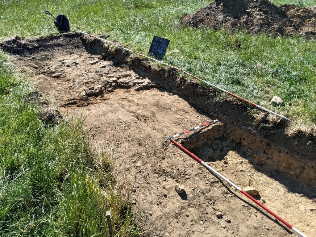 It’s perhaps too early to draw any conclusion but, could this be the remnant of the original mound. If so, John’s theory could be right about the soft sandy clay being the result of the degraded stone slumping down off the top of the original mound (and even used to backfill the ditch). Chris having finished is work in Trench 5 was able to get a good drone shot of the days work in the Trench 1 extension (in future referred to as Trench 1a).
Tuesday 13th June
Day 10 – Just five today, Bill, Andy and Peter with Steve and Chris joining in the afternoon. Bill and Andy had previously recorded the section in Trench 6 but Bill realised he had some unresolved issues with it when trying to draw it up – in particular on the east side, as it was not particularly clear where the top edge of the ditch was. The fill of the ditch having now dried out was showing a level of iron pan (not seen in this section before) which we have been using in other trenches as an indication of the upper lever of the ditch fill (i.e. interface between the fill and the subsoil).  It doesn’t show up on the photo but the iron pan seems to be going beyond what we assumed to be the eastern edge of the ditch – was the ditch over filled perhaps? (Trench 4 also showed a similar situation). Bill decided to take chase the natural back to the trench edge to get a better opinion but the issue wasn’t resolved.
Meanwhile in the recently extend Trench 1, Andy and Peter spent some time cleaning the existing section cut so that we could have a clearer understanding of what we were looking for when before starting to extend it. When we recorded this section last year we noticed that the subsoil (quite prominent in the ditch area) tapered off as you move inwards towards the centre of the mound. Replacing it was a thick layer of soft orange sandy clay which lay on top of the hard natural clay.  Once Bill had photographed the re-established section, Peter and Andy began to extend the trench, both widening it and extending it by about a metre towards the centre of the mound. The idea was to chase the natural but an area of soft sandy clay, suggesting a pit, meant slow progress – the ‘pit’ however turned out to be a shallow trough in the natural.
Steve arrived in the afternoon to he carried on his work in Trench 6a, exposing more of the upper wall on the west side – and when Chris arrived, he continued cutting the section across the feature in Trench 5. Despite nothing spectacular turning up in the feature, he was coming across quite a few patches of charcoal and the odd nodule of green coloured stone.
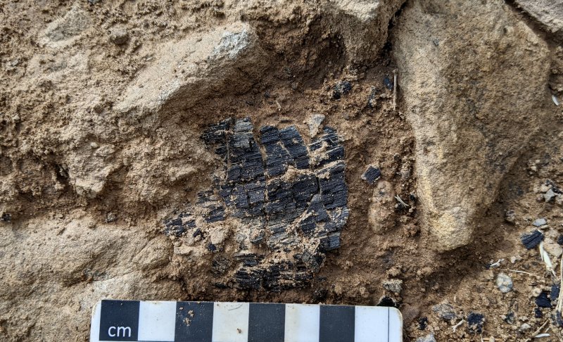
Charcoal in-situ in Trench 5’s stony mound feature
Thursday 8th June
Day 9 – Making up today’s team were Bill, Andy, Steve, Chris and John Smalley back from his hols, with Bob joining in the afternoon.
While Bill showed John around the trenches we’ve been working on, Steve and Chris carried on in their respective trenches (i.e. 5 and 6a). Trench 6a was almost ready for recording – Steve just needed to tidy up the upper section. In Trench 5 Chris continued quarter-sectioning his ‘cairn’, i.e. the stony mound associated with the burnt wood feature. This would enable him to increase our understanding of its construction and also establish the profile of the bedrock floor.  After Steve finished his work in Trench 6a on the area around the section wall, he moved onto the north side of the ditch.
  This allowed Bill and Andy to set to work recording the south section wall (the upper section had already been done but now the full bottom profile could be recorded).
  Steve’s work on the north side revealed more of what had previously been suspected i.e. a depression through the semi-bowl shape of the section leading towards the site’s western entrance. It’s still not clear what is going on in this area and more work maybe needed here to get a better understanding.
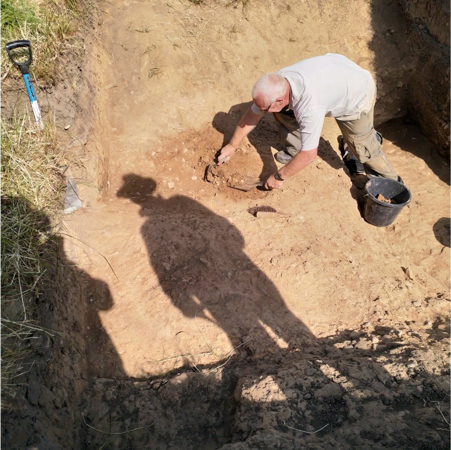
Steve it seems today was being supervised by Indiana Jones
Meanwhile John was given the task of cleaning the inner side of Trench 1. This work was in preparation for the trench’s extension towards the centre of the ring. This trench has been selected in preference over Trench 8 because, as mentioned last week, we needed a trench that had a recognisable natural surface. In the afternoon, John was joined by Bob and later in the day Nick the farmer arrived with his machine. With his usual precision, Nick deftly cut a 2 metre wide strip down to the subsoil. The strip was 6 metres long from the inner edge of the original trench towards the centre of the mound.  Interestingly, as Nick uncovered the last 2 metres, the ground became very stony – could this be the remnant of the original mound, with the surrounding material being sandy clay eroded from it? John finished off the day by taking the inner edge of the original trench down to the natural surface, while Bob cleaned the adjacent area ready for the photo.
Wednesday 31st May
Day 8 – Joining Bill and Chris today were Steve, Andy, John Needle and Phil. The weather has been kind to us this last few weeks but the sunny days has made photographer challenging. Today however with the sun obscured by cloud Bill was able to get some good shots of the trenches. Last week I mentioned cracks in the bedrock particularly in Trench 5 and 5a but could also could be seen in Trenches 6 and 7. In Trench 7 the crack seems to have damaged the square ended wall of the ditch producing a fissure on the the east side.  With Steve having finished cleaning out Trench 6 the previous day, Bill and Andy were able to record the section (Bill could therefore finish the section drawing started last year). Steve continued working on the other side of the baulk in Trench 6a. On the bottom of the west wall the ditch was becoming well defined, the top less so. In fact, as he moved northwards the general bowl shape seemed to disappear. The top edge was now very close to the edge of the trench. It was therefore decide to extend it another 20cm. There was suddenly a little excitement when Steve pulled out a coin, which soon subsided when it turned out to be a one pound coin. it was strange as it was a Scottish one ans Steve thought it to be a forgery as the date was missing.
John wondered if the soft clay in the northwest corner was actually another fill, suggesting perhaps this was an entrance into the ditch (an interesting suggestion which could be investigated at a later date). Once the Steve was happy with the west wall, he turned his attention to the east side of the ditch. Working from the bottom he was able to establish the eastern edge of the ditch and before he was able to uncovered the full profile of the eastern wall. Gratifyingly this seemed to match the projected line of it detected in Trench 6.
Chris returned to his feature in Trench 5 cutting a section through it. This showed that underneath the layer of stones was a thick layer of clayey sand lying on to of the bedrock. Chris will next cut a section in the opposite corner so that the floor of the trench can be mapped.  In Trench 8 the big question about the nature of the material being exposed needed to be answered so it was decided to cut a section into it. Phil was given this task and with the help of Andy wielding the mattock, managed to take it down another few inches.
  However this did not necessarily answer the question as, although no lower surface was detected, it was difficult to image the material being cut through was natural. It did not have the feel of the hard, fine pebble strewn clay detected in other trenches such as Trench 1 and Trench 5. In fact the occasional flat bedrock stone coming out of it seem to confirm it must have been deposited after the ditch had been cut. Andy used the auger to see if a lower surface could be detected. He reached the bedrock at a depth of about 70cm but no sign of a lower surface. Perhaps we would be better off extending one of the other trenches where the natural surface has been established such as Trench 1 or Trench 5.
In the afternoon we had a visit from Phil’s brother Tim Livesey who happens to be a geologist. Bill gave him a tour of the site before asking his opinion of the various conundrums we are presented with. Of particular interest was his description of the material fill of our ditch which he said was very sandy, in fact a silty sand, not really a clay. He gave us a explanation of the various sedimentary stones, starting from mudstone through millstone grit to course grained sandstone which is what we seem to have on our site – the only difference being the size of the grains. The strength of the stone all depended on what was binding the grains together and how the sediments were formed. In our case the thin laminations suggested regular alternating periods of deposition. Bill showed Tim a piece of bedrock broken of from the bottom of Trench 5a which showed layers of black and bright orange.

Piece of bedrock from Trench 5a
Tim said the orange was likely iron oxide and the black possibly manganese oxide. These substances precipitate out of the rock due moisture absorption in the rock and react with oxygen along the exposed laminations. The quality of the rock in this area is poor and therefore could be the source of much of the sandy material of the ditch fill. However in general the quality of the rock across the site varies so it is difficult to imagine it being the only source.
Another observation Tim made was the difference between the quality of bedrock floor and the side walls. He suggested that this was perhaps a level that the ancients had worked down to. Bill said he had also considered the possibility but had dismissed it as the depth of ditch was more or less consistent throughout the site (surely more that a coincident). However, on reflection, our ring ditch does sit on the break-of-slope which most likely reflects the shape of the the underlying bedrock, a sandstone banding created millions of years ago, before being scoured by glacial activity in more recent years.
Tuesday 30th May
Day 7 – Just a short afternoon session, with Bill today were Steve and newcomer Phil Livesey. Bill introduced Phil to Trench 8 explaining trowelling technique to flatten the surface. This hopefully would identify the extent of the soft areas discovered last time out to see if they represented a feature in the hard sandy clay. Steve continued his work in Trench 6 clearing out the rest of the fill from the centre area. This is where the large flat stone had appeared. Once removed, the remaining fill consisted of smaller rounded stones. Finally the whole of the bottom of Trench 6 when uncovered revealed a couple more fissures running on a different angle.  Meanwhile Phil in Trench 8 was making good progress, although as he trowelled down the soft areas identified before were getting smaller. By the time he had finished only small pockets remained. The big quest ion here is, is this surface a manmade deposit or is just natural. If the latter, it could mean the whole of the central mound is natural.
Thursday 25th May
Day6 – Just five out day, with Bill and Chris were Andy, Steve and Peter. While Chris continues his work on the burnt wood feature in Trench 5, Andy and Peter continued with their efforts in Trench 8. On the last visit, a patch of soft sandy clay material had emerged on the east side of the trench towards its south end. Further trowelling revealed this spreading over towards the west side of the trench although a specific edge to was difficult to discern. If fact Peter was thinking it may be going under the harder stony clay area further north (Bill said if so, this would become apparent as we trowelled down keeping the surface flat).
In Trench 6 Steve got to work removing the central section which had been left when the trench was first dug. He started on the west side where he had uncovered the bedrock floor on his last visit. 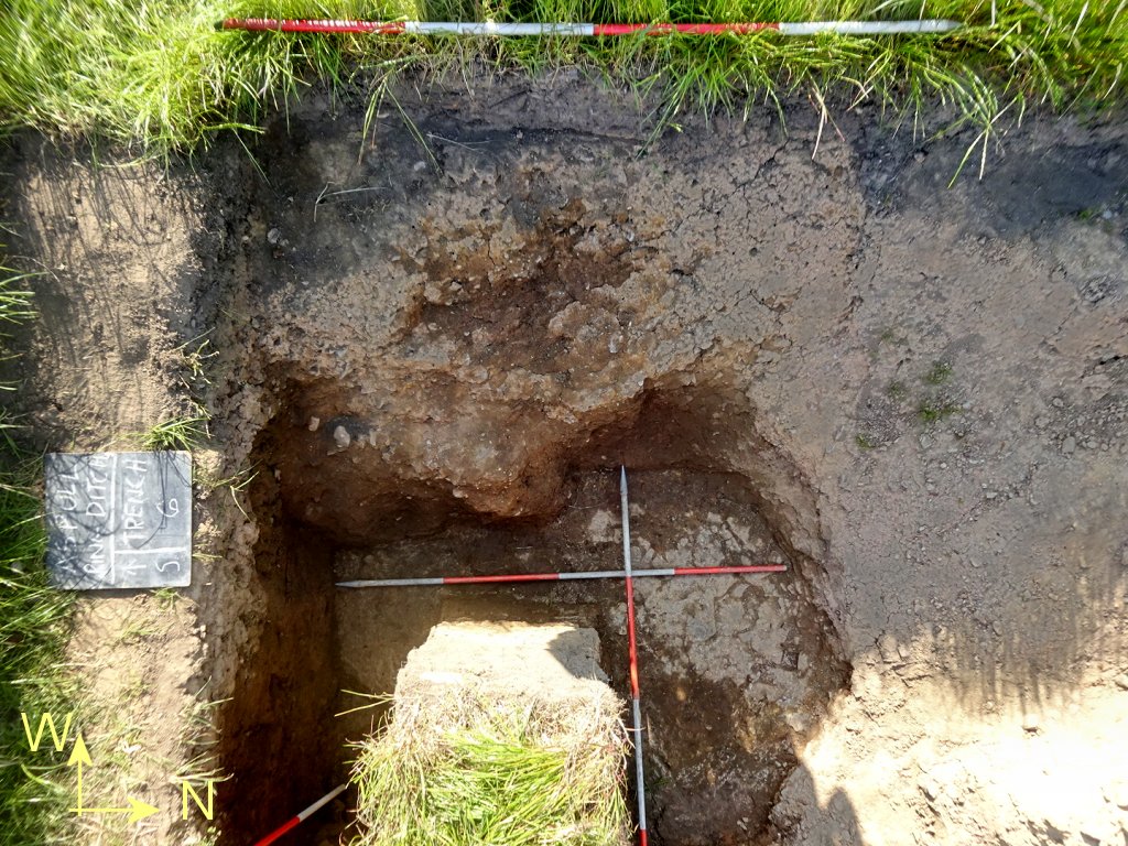 As he uncovered more of the floor, he realised it was dipping downwards. By the time he reached roughly the centre of the ditch, the depth of the floor was 1.7m (the deepest so far). At this point he noticed a crack in the floor running roughly north south. There was also a large flat stone appearing at a shallower depth (about a metre down) which he left in place, attacking the rest of the fill from the east side.
The appearance of the crack is perhaps good news as it might mean that water will drain away as it does in the other trenches. The cracks in Trench 5 and 5a are the biggest, one in fact tracing across both trenches. The date when these cracks occurred was causing some controversy as the large one could be seen in the section of Trench 5a seemingly travelling up through the fill. Chris had also detected it in the mound of the burnt wood feature. This would suggest the cracks occurred after the ditches had been back filled (and settled). One feasible explanation was that the underlaying ground had been disturbed due the the coal mining operations which was quite prevalent in the area in the 19th century.
Bill continued his quest to set to check that all the pegs where in the right place according to the plan (over time some of the original pegs had been lost, some had come out and been put back in the wrong place and some alignments weren’t quite right). By lunchtime however he was finally happy with all their locations and, with yogurt pot lids attached, Chris was able to pick them up on his drone survey (managing to do this before he left early in the afternoon). Later in the afternoon we had a visit from Patrick who had been unwell for the last week or so (thinks it was Corvid although it didn’t test as it). He soon caught up on progress and was fascinated by the possible small piece of copper ore which suggests trading or locally smelting.
Before we left for the day Steve managed to secure the use of the farmer’s strimmer. The grass around the edges of the trenches where the farmer had been unable to reach with his mower had become dangerously long and it would only be a matter of time before it caused an accident (Steve was looking forward to giving the trenches a good haircut).
Tuesday 23th May
Day5 – Similar turnout as last week i.e. Chris, Bill, Andy, Peter, Steve and John Needle. Chris continued investigating the ‘cairn’ surrounding the burnt wood feature in Trench 5. His intention today was to quarter section it in the region of the feature (i.e. SE corner) but leaving the feature untouched. This should produce 2 sections (n/s and e/w) showing any structure. An arrangement of large stones was uncovered surrounded by a soft sandy material. The arrangement suggested a posthole with with packing stones but, when the feature was half-sectioned, this proved not to be the case. 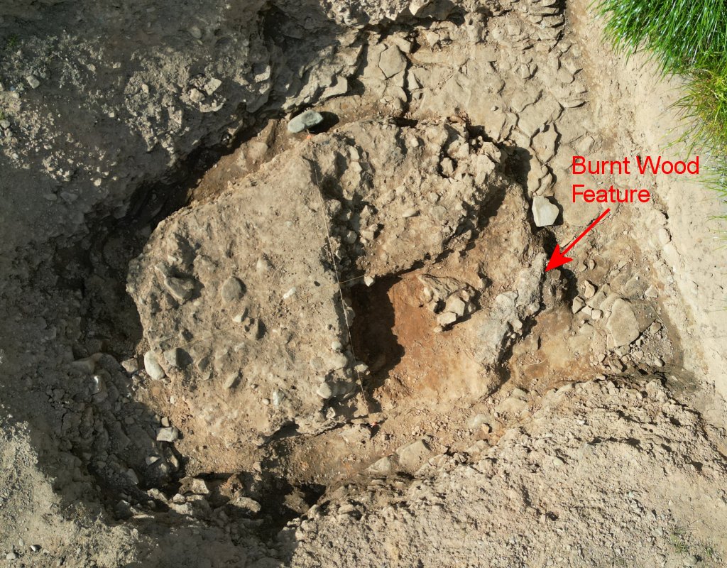 All the material retrieved from the cairn was retained for sieving.
Bill had brought along an old swing seat frame with the intention of repurposing it as an ‘A’ frame to mount sieves from. Bill had made one sieve himself, using chicken wire in the bottom of an old delivery tray, while Chris had brought along a finer sieve borrowed from his Cheshire group.  Processing involve using the coarser chicken wire first to filter out larger lumps before passing through the fine sieve. The processing proved successful, producing a selection of interesting small stone from the cairn in Trench 5, including translucent quartz pebbles, a couple of pieces of flint or chert and a couple of pieces of cinder (bottom right in the photo).
  One stone looked like it could be copper ore although this would need to be tested. There were plenty pieces of charcoal, as would be expected but it was surprising to find a small piece of cannel coal (Steve also produced a small piece from Trench 6a). Nothing spectacular this time but it is early days and material from the mound might prove more fruitful.
Meanwhile Peter and Andy continued work in Trench 8, removing the rest of the plough soil and subsoil from the west side of the trench down to the bright orange sandy clay layer below. It was expected to see more of the cobble stones which had appeared near the inner edge of the ditch but the adjacent area just showed a hard clay surface. Further to the south however, on the west side, some stones did appear but in general the appearance of stones was patchy. The underlying material in the area towards the southern end of the trench on the east was becoming quite soft – could this be a feature, something to investigate next time. 
Steve continued is work, help by John, in Trench 6 / 6a, uncovering the outer edge of the ditch. Although the flat rock floor of the ditch was well defined (as in Trench 7), there was no bedrock in the side wall, so Steve was relying on the hard clay to define its shape. The main issue was the disparity between the surface seen in Trench 6 and the surface revealed in Trench 6a (as good 20cm different over the short 40cm distance between the two). In the end when all the soft fill material had been removed a complex of steps and scoops had been revealed. In Trench 6a, the upper half of the ditch was showing a distinct semi-spherical bowl shape breaking into a steep slope down to the bedrock floor. Moving toward Trench 6, this arrangement became interrupted by a shape step inwards in both the upper and lower sections (although not as pronounced in the upper section). Before reaching the Trench 6 proper, another notch appeared in the lower section. It turns out to be quite a complicated shape, maybe best captured by Chris 3D capabilities.  With out bedrock in the sidewall, determining the shape of the ditch wall was always going to be a challenge, so this was our best guess at it (the next challenge would be its inner wall .
In the afternoon we were visited by Nick the farmer who showed great interest in our latest work. Bill explained our intentions with future excavations and Nick did seem particularly perturbed about Bill’s description of an extended Trench 8 reaching into the centre of the mound.
Thursday 18th May
Day4 – Good turnout today, joining Chris and Bill were Andy, Peter, Steve and John Needle, with Martin joining in the afternoon. As we climbed up the hill to the site we noticed the famer had kindly mowed the grass for us (well best he could avoiding the trenches, spoil heaps and pegs). It did mean life would be much easier for us moving around the site.
Chris with help from John, continued excavating the ‘cairn’ over the burnt wood feature, while Andy set to with the task of cleaning Trench 7 ready for recording. Steve was given the job of removing the baulk between Trench 6 and 6a starting with the west end, so that the mismatch between the western edge of the ditch in each trench could be resolved. Peter was asked to look at Trench 8 with a view to preparing for its extension (this is the trench selected to be extended towards the centre to get a better understanding of the mound’s makeup). Meanwhile Chris in Trench 5 was discovering more and more charcoal fragments intermingled with the cobbles of the feature (at some point Chris says he intends quarter-sectioning the feature to investigate it interior).
In Trench 7 Andy decided he needed to cut back the upper west end edge of the ditch as it wasn’t clear we had the ditch’s edge, the upper surface in this area being unusually soft. After cutting it back to a depth of about 50cm he came across the hard clay that formed the edge of the ditch further down. It was difficult to see a difference between the fill of the ditch and the soft clay on the upper edge but it was also difficult to imagine that the fill extend beyond the edge (Bill pointed out we were having a similar mystery in the upper edge of Trench 6a).  In Trench 8 Peter managed to clean a 70cm wide strip down the east side of the trench from the inner edge of the ditch to the inner edge of the trench, taking of the remaining top soil and subsoil down to the next layer. This was a bright orange sandy clay containing a number of large stone cobbles just outside the inner edge of the ditch (the thought was this could be part of the mound). Next job would be to cut into them to see if there is and underlying natural surface which would prove if it was mound material.
  In Trench 6 Steve was making great progress taking down the baulk while Bill was helping by removing the spoil that had collapsed into Trench 6a. After lunch Martin arrived to take over from Bill and by the end of the day all the spoil had been removed and Steve had joined the two trenches . This exposed a quite impressive flat bedrock floor. The next task would be to clean the west wall of the ditch to get an idea of its shape.
 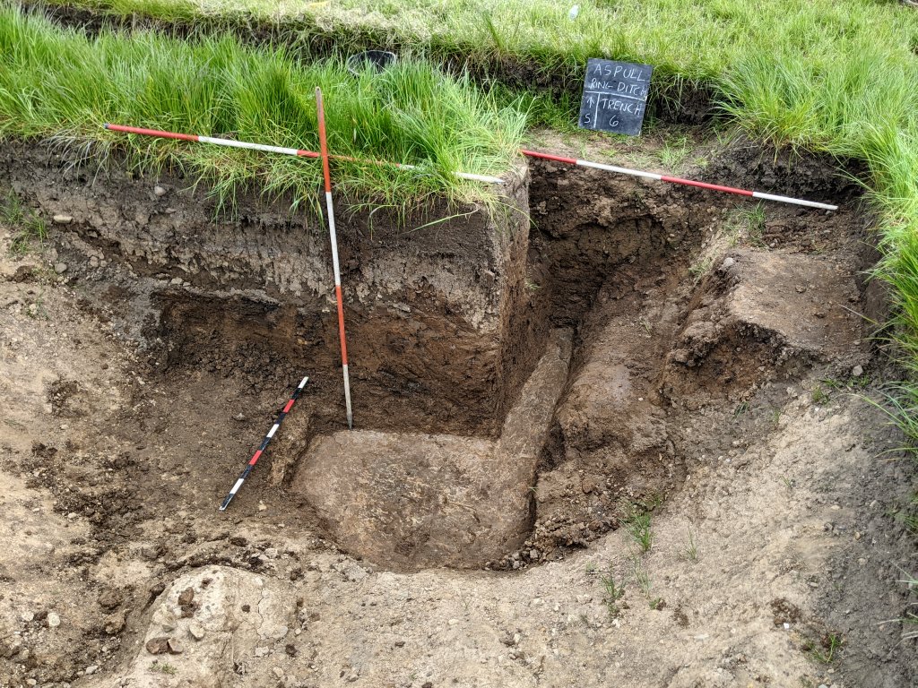 Before leaving for the day Bill and Andy recoded the section in the Trench 7.
Thursday 11th May
Day3 – As is always the way, the day you think is going to be best weather-wise turns out to be the worst – too late to change. However Chris and Steve being available on this good day decided to come out and take advantage of the fine weather. They’ve both been working on what Chris is terming (tongue in cheek) a cairn over the burnt wood feature in Trench 5 so that’s what they concentrated on today. Have had the baulk removed the previous day, they both were able to get to work straight away on the feature itself by removing the covering sheets place over last year’s exposed cobbles. The feature appears to be a 1.5m x 1.5m x 0.3m pile of stones placed at the terminus of a section of the ditch. There appear to be layers of stone and sand, with the sand containing fragments of burnt wood with a large fragment 40cm long (Carbon14 date for this came it at between 1500 and 1700 BC with a high probability in the 1600s BC).  First job was to clean the newly exposed surface to highlight the new burnt fragments exposed the day before at the western end of the feature. At this point Chris took a recording using the lidar feature on his iPhone.
  Work then proceeded from east to west taking off the sandy material down to the top of the layer of stones that the feature is constructed from. Before leaving Chris carried out a drone survey from a height of 5m and 1m .
Wednesday 10th May
Day2 – Another decent turnout. Despite the drizzly weather, joining Bill and Andy today were newcomer Phil Livesey and Steve who arrived later in the morning and Marin joined in the afternoon.
While Bill gave Phil a tour of the site, Andy set to work drying off Trench 7 ready for more work on it. It had become clear the previous week that the section wall needed to be realigned to more closely match the alignment the ditch was now presenting itself. Andy put in the string line approx 34cm further back along the north/south datum on Peg15, to the northeast corner of the trench (still not exactly square with the ditch enough to give us idea of the direction the its outer edge). We then began the task of cutting down the section wall starting with the turf (Phil catching the sods in a bucket and Andy disposing of them). By lunch time most of the section wall had been cut back.
When Steve arrived just before lunch, he was set with task of removing the central baulk in Trench 5. Phil joined him when he became available. To protect the burnt wood feature, Steve put a sheet down and worked his way from that side to minimise the mess to the rest of the trench (the final section was pushed over by Phil in Steve’s awaiting buckets). Steve then set about towelling down towards the cobble layer which seem to overlay the actual burnt wood feature. As he did so we came across patches of charcoal which he left in situ covering them with a shovel.  After lunch, Bill finished cutting the section wall back in Trench 7 and cleaning the debris from the bottom. Andy then set about trowelling the west side trying to establish its profile (helped by Martin when he arrived). By the end of the day we seemed to have the profile we were looking for (although Andy wasn’t fully convinced). The section did show however a significant layer of sticky clay at the bottom of the trench partially rising up the west wall. Between it and the usual fill of the ditch there was also a noticeable band of silty sand. Phil (who has a degree in geology noticed that the clay had a blue tinge which he though demonstrated that it had not been exposed to the atmosphere – after a few days it should oxides and turn more orange (Bill took a sample to test his theory).
  Before leaving for the day Bill had a look at the waterlogging in Trench 6a. The amount of water in the bottom was as great has it had been and Bill was able to remove it just using a bucket. He then tackled the remaining baulk to see if he could find the bedrock floor (the theory being that it may help the water to drain). The going was very sticky but eventually he manage to reach the bottom (but he would have to wait and see if it help with drainage).
Thursday 4th May
Day1 (Season2) – First day proper on site and a good turn out. Joining the team with Bill and Chris were Andy, Steve and John Needle (with Patrick, Martin and Jim Meehan joining in the afternoon). First job was to clean out trenches left open from last year – so while Steve and John tackled Trench 5a, Andy got stuck into Trench 7 while Chris started to look at cleaning Trench 5. However Bill was keen to revisit last month’s coring exercise by have another look at the area near Trench 4. This was where the previous result was showing no ditch where there obviously should be one. While Chris was resetting his grid, Bill measured in the peg nearest to Trench 4 which Chris had had to admit was not quite square with vertical (north south) baseline (in fact Bill found it to be only 1.7° out). More coring on lines 1 to 4 proved the ditch was there, showing that there wasn’t a gap at this point (however there were still some lines where the ditch hadn’t been detected which will need further investigation at some point). 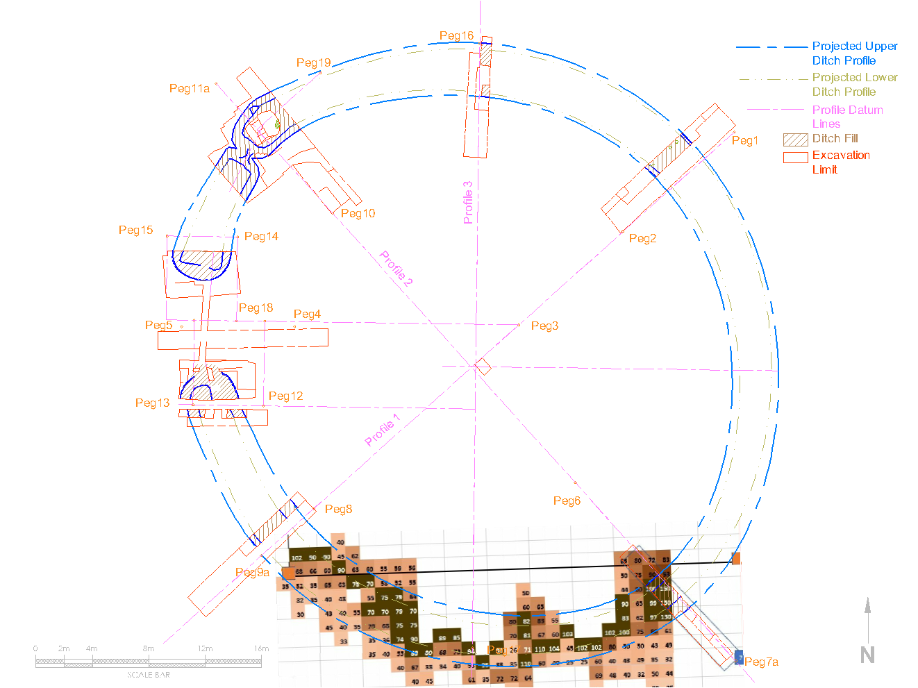 In Trench 7 however, Andy was struggling to relocate the outer edge of the ditch having come across a large cobble stone lying under what he thought was the edge. Bill was convinced though that it was part of the edge – in fact this ditch terminus was looking more like the terminus in Trench 5a i.e. squared ended (although only the bottom section, the upper section still retaining its semi-bowl shape). Bill decided we needed to realign the north wall section to match the alignment of the ditch was now showing. When Martin arrived he helped to clear out the bottom of the trench and by the end of the day the flat bedrock bottom of the trench was clearly visible.
  Meanwhile Steve and John where making a great job of cleaning out Trench 5/5a. By the end of the day both trenches were looking pristine. However it was clear the next job would be to remove the central baulk which would certainly mess up Trench 5 again (but at least it would be easier to clean up again).
Before they left for the day Bill and Patrick discussed the next intervention which would enable them to investigate the internal mound. It was decided to get Nick the farmer to extend Trench 8 (which had only been partially excavated, enough to locate the ditch) towards the centre. Eventually we would take it all the way to the centre (and perhaps beyond) but initially just 6m from it’s current extent. This would enable us to get a better idea of what we were dealing with. Patrick as usual would arrange for this to be done in the next few weeks, in the meantime there was plenty for us to be getting on with in the existing trenches (i.e. realigning Trench 7, removing the baulk in Trench 5 and not least tackling the water logged Trench 6).
Thursday 20th April
Chris return today with Patrick instead of Bill to continue with the coring exercise between Trenches 3 and 4. They eventually reached Trench 3 and crossed over it (recording the depth by just dangling a tape down into it). The results were very promising although there were some anomalies such the 25m line which hit rock every time despite being so close to Trench 3. The 16m line was also showing bedrock where there should be ditch (this could be potentially showing another junction similar to Trench 5/5a). In general though the outer edge of the ditch seemed to be following the predicted line – although when Bill later plotted it on the plan drawing, the arch of it, did seem to be too shallow. Chris however when plotting the results on the overhead drone image had to admit he may not have achieved a perpendicular horizontal (east west) baseline and in fact had had to rotate the plot by 2.3° to get it to match the pegs showing on the image.  It was generally agreed that a return visit to some of the areas would be required for further investigation, particularly in the area around Trench 4 which wasn’t showing much sign of a ditch.
Tuesday 18th April
This visit was arranged at short notice and as a result only Chris and Bill were able to make it but it was sufficient to enable Chris to extend his coring exercise. It was also an opportunity for Bill to get a better understanding of the process.
It wasn’t clear to him whether the figures produced represented the corer bottoming out or just the depth of dark (i.e. ditch fill) material. Chris pointed out that, in the area he was surveying, the bedrock is near the surface with little or no subsoil between it or the the plough soil. This is particularly true on the outside of the ditch – but not so much on the inside so the figures (in general) represent the depth of the bedrock. In fact, as the inside edge of the ditch was difficult to determine, the survey carried out today concentrated on searching for the the outside edge.
Another problem is knowing whether the corer has in fact hit the bedrock or hit a random stone (an issue we had with both the probe and auger). As the corer is made of quite strong metal so it is able to push past small stone. Larger stone do defeat it but they feel is very different – when the corer thuds onto the bedrock the vibration can be felt under foot so it’s usually obvious what the corer has hit.
Whilst Chris continued with the survey, Bill took the opportunity to check and reset some of the datums, installing new pegs where necessary. This included removing the Peg11 from Trench 5 to allow the baulk could be removed so that the burnt wood feature could be properly excavated (a new position behind the spoil heap was selected for it). Bill also re-installed Peg9 in a new position in the area of the refilled Trench 4. This done, Bill joined
Friday 14th April
Despite the weather Chris and Patrick ventured out again to continue a coring survey started a few weeks before. As mentioned before, the process involves pushing the corer down into the ground to extract cross section of the substrate. The colouration of the extracted sample indicates where the ditch is and where it isn’t (unless the corer bottoms out on bedrock which obviously indicates no ditch). 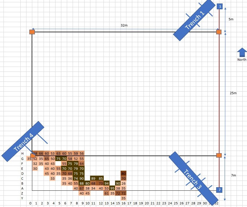 The area chosen was to the east of the now back filled Trench 4 and, as before, Chris has plotted the results using colours to indicate ditch depth. As was seen in Trench 3, the bedrock is found to be close to the surface (35cm) in the section of the field on the outside of the ditch. On the inside of the ditch, it seems to be about 60-50cms. The readings of 70 (cm) and above are probably full depth ditch (i.e. 1.5m). (Note: in position F5 they hit a stone, and a couple more attempts couldn’t get past it, so is left blank. C4 – H4 looks interesting, we may have to revisit that line.
Working eastwards from Trench 4, as can been seen, the results Chris got were initially very promising with the ditch being where it was predicted to be. However as the the survey progressed the picture became more complex – obviously more work to be done but the work is certainly throwing up areas for further investigation.
Monday 27th March
Chris attempted another coring session, with Patrick and his neighbour (who happen to be available at short notice). This time Chris marked out two areas for testing, again it was just to test the effectiveness of the technique for detecting where the ditch is (and where it isn’t). The first area was next to Trench 7 and the second next to Trench 5a. 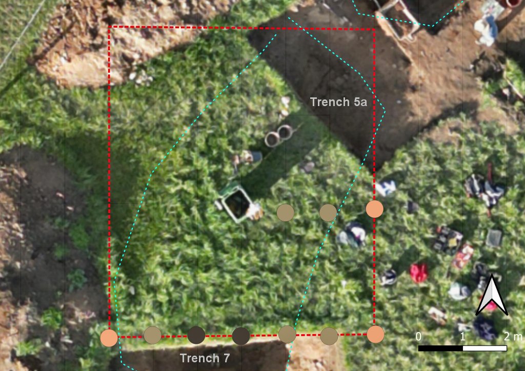 The results we very favourable showing that this technique will be very useful in discovering if there are any more gaps around the circuit.
Soil Samples
About 5 weeks ago Chris took some soil samples from the section in trench 5A and left them to settle in water. They are now showing differences in colours. 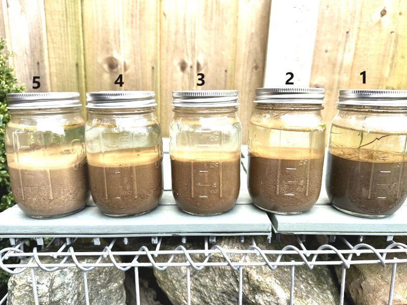 Sample 1 was taken below the top soil, with samples then taken approximately every 25cm in each colour change, with sample 5 coming from the bottom grey layer.
 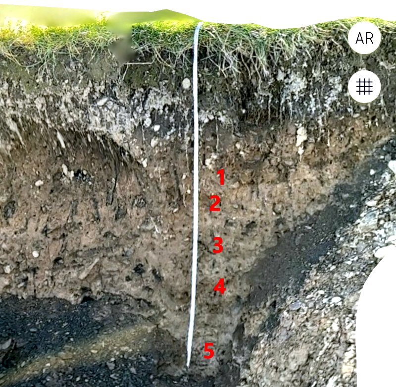 Conclusions: you have to wait 4 weeks for the samples to settle fully (even after 2/3 weeks they all looked the same). There is a colour change in each layer (probably need to use the Munsell chart to record accurately – Chris tried to read the RGB values for each jar but I can’t see it add any more information). We can clearly see by eye the grey clay layer at the bottom and the image from his 3D model shows the layer more clearly.
They were visible to the eye on the day, but other times it all looks mostly the same colour (particularly when dry – maybe the partial collapse in this trench helped make the colours visible). Trench 5A and Trench 7 (which could well be the same section) may have been backfilled differently to the rest of the site. It will be worth doing the same sampling to the other trenches to compare.
Tuesday 7th March
Chris Drabble has obtained a 1m long corer and has been keen to use it – so today, with his son being off work and willing to help, they both went on site to see if it could be of some use. At first the results were disappointing – it was easy enough to get through the 20-30cm of top soil but very hard to go deeper. He therefore adjusted the process to take multiple cores from same hole (making sure to mark hole so as not lose it). This allowed them to go much deeper.
Using this technique he was able to get a very clear distinction between top soil and the natural orange clay beneath indicating ‘No Ditch here’. He was also able to get sandy brown ditch fill up to 80cm down suggesting ‘Ditch here’. Rather than doing a full survey, he tried to gain experience at different areas of the site. So: Directly in front of the gate: Natural. 3m in from the gate: Ditch fill. 5m North of the gate by the fence: Natural. 3m to the West: Ditch fill.
They also took 5 samples adjacent to the test pit in the mound – all showed a mix of red/orange/sandy material just like the test pit itself. Three of the tests hit stone and could go no deeper. They also tried to find the iron pan adjacent to Trench 6.  They weren’t sure they got that, but did get different coloured clay layers.
  Adjacent to the south end of Trench 3 where the bedrock is close to the surface, they hit bedrock 30cm down.
Summary
All results were exactly what I expected. Not too surprising as Chris deliberately picked areas clearly outside the ditch to detect natural, and areas clearly in the ditch to check for ditch fill. Chris’ experience of using the corer was that as you push the corer in, the sample seems to compress to the point it will go in no further. However the corer has a scale on the outside so you can record the actual depth, and then record the sample. Typically you could push down 30cm but would only pull up a 20cm core, so that can be adjust for this effect.
Chris wondered how we could conduct a survey. His GPS at 1 to 2m wasn’t accurate enough so proposed using a reference such as the entrance gate or a peg. Bill said it would be preferable to use two pegs for reference to get a base datum line, then set out a grid from it. With the weather no looking to good it wasn’t certain there would be another opportunity for a site visit.