
In 2015 Derek Winstanley, with the help of Wigan Arch Soc, produced a paper on the history of Wigan Pier . Here is an extract talking about the origins of the Douglas Navigation basin and Wigan Dock.
We do not have a map of the Douglas Navigation in Wigan in the 1700s. However, information can be gleaned about the navigation from historical sources. Whitaker (1775, 37, 44-45) states that c.1735, when the navigation was being constructed, substantial evidence of a major battle between Britons and Saxons was discovered. Whitaker states that the battle was probably fought in the marshy Parson’s Meadow on the south side of the River Douglas. A large number of horse and human bones, spurs and an amazing quantity of horse shoes (some 500-600 lbs in weight) were discovered, “All along the course of the channel from the termination of the Dock to the point of Pool-bridge, for forty or fifty roods [~250-300 yards] in length and seven or eight yards in breadth…” According to Whitaker, the legendary King Arthur was victorious in this battle; others believe it could have been a Norman or Civil War battle. Irrespective of the battle, questions arise as to the location of the dock and Pool Bridge.
The 1802 map shows two canalized channels, or cuts, branching northwards off the River Douglas between two potteries, one owned by Mr. Leigh. The description of a channel for some 40-50 roods from the dock is consistent with the length of both channels shown on the 1802 map. These two canalized channels are not shown on the 1832 Boundary Commission Map, so they must have been filled before surveying was conducted. The 1802 map shows some five buildings at the terminal point of these two canalized sections, so it is reasonable to interpret that these buildings and canalized channels formed the end section of the Douglas Navigation and the site of Wigan Dock.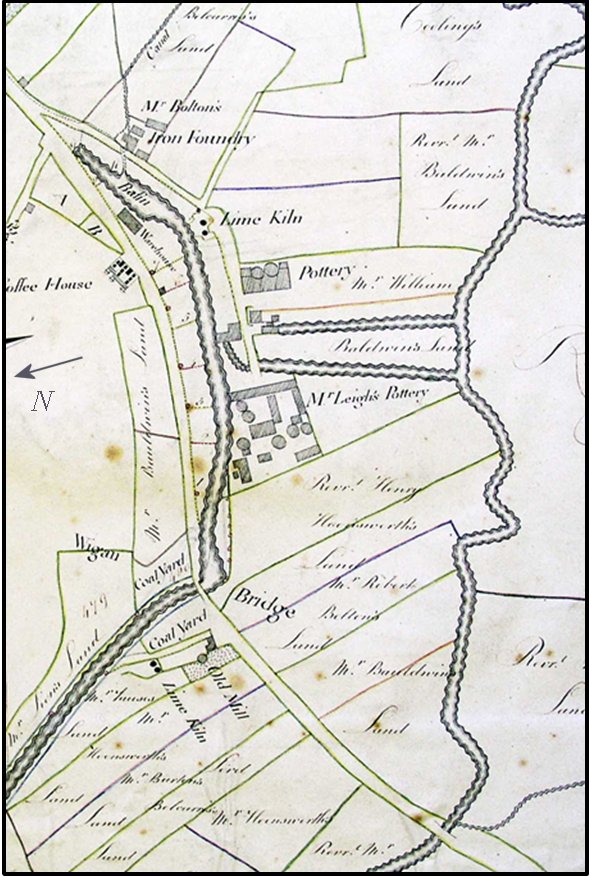
Pool Bridge probably was the name for the wooden bridge across the River Douglas shown on the 1849 and subsequent Ordnance Survey (OS) maps and town plans as Parson’s Meadow Bridge. Parson’s Meadow Bridge is at the southern end of what is Pottery Terrace today. A short distance upstream of the bridge, Poolstock Brook flows from Poolstock into Smithy Brook, which in turn flows into the River Douglas.
A key unresolved issue is whether the Leeds and Liverpool Canal Basin was built specifically for the canal in the 1780s and 1790s, or whether it represents a slightly modified older terminal basin built for the navigation. Mike Clarke, a canal expert, believes the latter. Complications arise in interpreting the sequence of developments from the navigation to the canal, because the 1802 map was drawn a decade after the Leeds and Liverpool Canal was constructed and the map shows the canal, the canal basin and the navigation. On the 1802 map, the buildings at the end section of the Douglas Navigation are shown to be on, or close to the canal wharf. However, navigation buildings close to the later canal do not necessarily mean that the north-south canalized channels joined an earlier basin constructed for the navigation.
Mike Clarke acknowledges that early accounts of the navigation are difficult to interpret and speculates that in constructing the navigation there was, “Work on the cut above Pool Bridge, probably the terminal basin…”…
We find no evidence of a terminal basin for the navigation on the site of the canal basin, but there is evidence of terminal dock area at the end of the two cuts shown on the 1802 map. Our interpretation is that the two north-to-south canalized channels, or cuts, shown on the 1802 map, together with the buildings at the northern end represented the terminal dock area for the Douglas Navigation in Wigan. It is probable that the canalized section shown on the 1802 map at the eastern end of the basin fed water into the north end of the navigation, and later into the canal basin. It is also possible that, when the canal basin was built, there may well have been an existing extensive large ditch created from clay extraction for the potteries.
Since this report was written more information has come to light which suggests that Mike’s theory might actually be correct. This has resulted from our Douglas River Project where we have been looking at the Navigation’s river locks. Mike’s website has13 in all and we had more or less located them all except the first one out called Harrison Platt lock. It’s described as being on the end of a man-made section from the terminal basin. On the 1849 OS map, Harrisons Meadow Chemical Works is shown located behind what is now B&Q on the Robin Park estate on the west bank of the Douglas. This seemed to be the obvious place for the lock.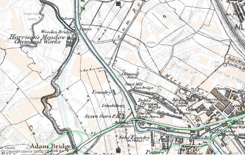 If true, it seems logical that the canal, as it is now, follows the route of the channel that Mike refers to into Wigan – and, therefore, the current basin was also the Navigation terminus. More research is needed as there is a huge difference in height at this point but other documents seem to support the theory suggesting that there was a double lock here. There is also some sense in it, as a direct route into Wallgate would certainly avoid the torturous journey around Adam Bridge (and avoid the need for a weir on the river in an area notorious for its flooding issues).