
This particular Road leading north out of Wigan through Standish and on to Walton-le-Dale (Margary 70c) was first investigated by the Wigan Archaeological Society in the early 1980’s. The initial investigations centered around the accounts given by W Thompson Watkin (Roman Lancashire 1883 p.66-69) who was able to trace the Road in the late 19th century in the Wigan area as far as Standish. However he could find little evidence himself of the Road north of Standish, relying heavily on previous sightings such as Sibson’s who claimed he could trace the road “from Standish through Welch Whithill (or Whittle) to Euxton Burgh”. Another reported sighting, said to be 13 yards wide and “about a quarter of a mile to the north-north-east of Euxton”, pointed it towards the park at Worden Hall (this must surely mean the wood near Worden Old Hall which was on the east side of the A49). Watkin goes on to describe further reports of sightings leading through Bamber Bridge and on to the Ribble crossing south of Preston.
For many years this was the excepted route i.e. a road called Meanygate (or Mainway Gate on early maps) in Bamber Bridge, lining up with a straight line path through Cinder Wood near Cuerden Hall and on south towards Old Worden Hall (which still exist by the way next to the main road through modern Buckshaw village). However excavations in 1996 at Walton-le-Dale revealed a remarkable section of the road which dramatically changed the picture as it pointed, not towards Bamber Bridge, but Leyland.
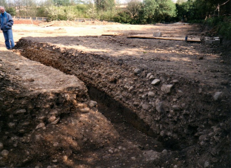
Roman Road at Walton-le-Dale – Copyright – Wigan Archaeological Society
This well defined section of road seemed to line up with Todd Lane, Stanifield Lane and on towards Euxton, lining up pretty well with Wigan Road (i.e. the A49) as it passes through Euxton village.
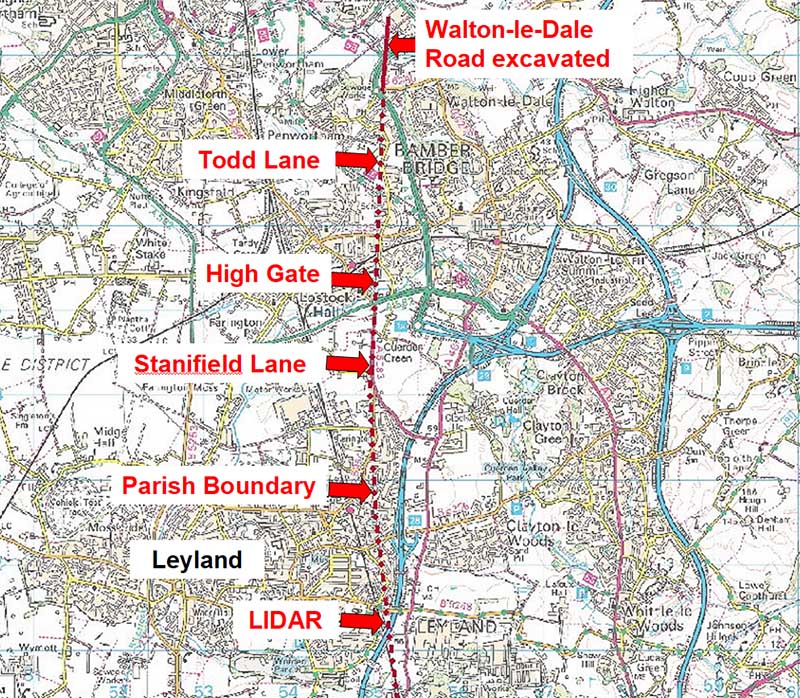
Image courtesy of David Ratledge (Roman Roads in Lancashire)
This alignment was confirmed in 2018 by excavations by Salford Archaeology in advance of a proposed new development site south of the M65 terminus. A 50 metre long section of the road was discovered in a field on the east side of Stanifield lane and showed it to be over 11 metres wide and in remarkably good condition. It was made of rammed cobbles and cambered on each site (no surface gravel metalling). On the east side there was a well defined ‘V’ shaped ditch but the west side had been truncated by modern activity (you can see more details here – see also Current Archaeology No.349).
Research in the Wigan Area.
Besides Watkin, another early reference to the line of the Road in the Wigan area is the One Inch OS Map which was first published between 1842 and 1844. A section of this map north of Wigan (see below) shows the road as a continuation of Mesnes Street, crossing the railway line at a point where a factory is indicated. The line is then shown crossing the Wigan boundary at Brimelow farm and on past Brockhurst to Round Moor Farm. Here the line ends where the track from Round Moor to Wakefield’s farm crosses it. Curiously this line, from Wigan town centre to Round Moor, is not shown on the Six Inch OS Map of 1849 or any other later edition.

In his account, Watkin relates to the road being “first detected … by a Ralph Thicknesse … in a field called Beggar’s Walk near Ryland’s factory. The railway from Wigan to Preston crossed it at this point”. Watkin also quotes Sibson as finding the road “in the bleaching crofts near Ryland’s factory in the valley at the north-east end of Wigan Mains (Mesnes) and in the next field near the footroad on the east side of the Mains”.
Ryland’s factory (or Mill) was built by Mr. Ryland’s in the early 19th century and should not be confused with the later Ryland’s factory (now derelict but last used by the Wigan & Leigh College) which is located on the north side of Mesnes Park. The original Ryland’s Mill was located further north-east on the other side of the railway in an area now occupied by a small housing estate off Barnsley Street. This places the road on the line indicated on the One Inch OS Map.
Beggar’s Walk refers to a field bounded by a track of the same name. This track appears on the Six Inch OS Map of 1849 (see below) and is shown leading north from the old Ryland’s Mill, turning sharply eastward towards in the area where Spencer Road crosses the railway. Beggar’s Walk is then shown continuing on the other side of the railway leading towards Wigan Lane just south of the Cherry Gardens pub. The field bounded by the Walk on the west side of the railway shows an alignment of field boundaries which coincide more or less with the line shown on the One Inch OS map.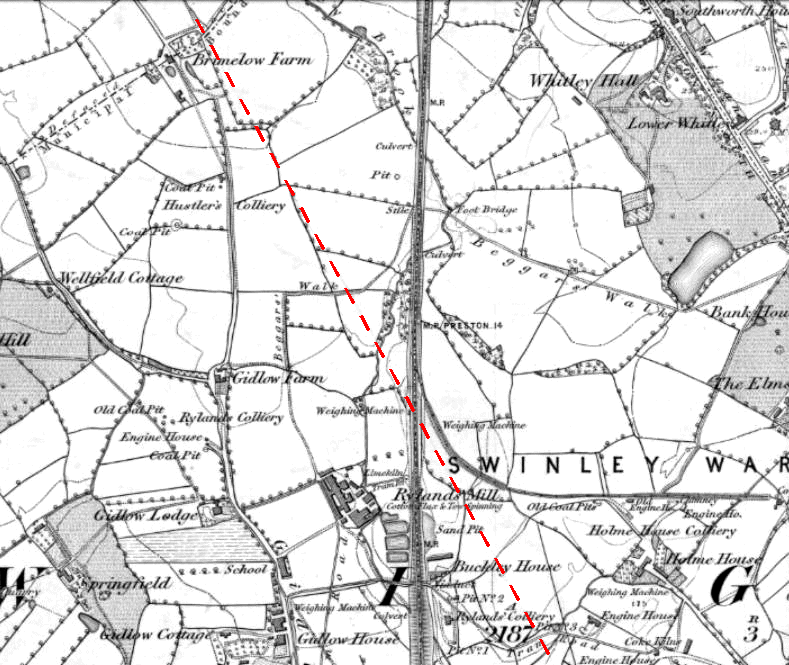
Watkin goes on to say that he found the road “in a field called Patten Hey“ to the north-east of Beggar’s Walk. He describes it as “being 14 yards in width, and a yard in depth, formed of gravel, with blocks of yellow-coloured freestone”. This is a remarkable description as roads of this width are usually associated routes connecting major settlements in the Roman Empire.
Patten Hey does not appear on the Wigan Tithe Apportionments and Map of 1838 and despite strenuous effort we have so far been unable to identify it on any other map of the area. However it is likely to be in the area where the Milliken factory (previously Tupperware and ROF) is located on the north side of Spencer Road.
From Patten Hey Watkin describes the road forming “a cart-road to Standish, proceeding through the middle of Old Meadow Field, and along the side of the next one to Barn Hey, where it was discoverable, and the line of its gravel and stones marking its progress up the hill to Standish”.
Cart-road to Standish. On the One Inch OS Map and on the later Six Inch Map there is a road shown going NNW from the Wigan border at Brimlow which meets a road leading east from Brockhurst at right angles. The road from Brockhurst carries on for a short distance before turning sharply northwards towards Round Moor farm (this road is also shown quite prominently on the Standish Estate map of 1763 which appears in Porteus’ “History of Standish”).
The stretch between Brimlow and the Brockhurst road is on the right alignment but the section heading towards Round Moor farm is neither straight nor on the alignment. Both these stretches are not now visible on the ground and do not appear on any later maps of the area. The road from Brockhurst, instead of turning north, now continues in a straight line towards Boar’s Head where it comes out near the present day cemetery entrance. The present day road from Brimlow to the Brockhurst road, which is a continuation of Gidlow Lane, runs parallel to the old road about seventy metres to the east of it. 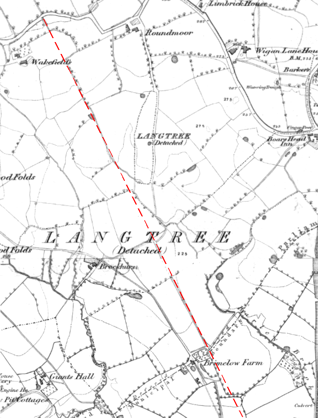
Old Meadow Field. The Standish Estate map of 1763 has an Old Meadow just to the north of Round Moor farm but it is not certain this the the field referred by Watkin.
Barn Hey. This name appears a number of times on the Standish Estate map but none specifically on the perceived alignment. It is curious to know why Watkin selects just these field names and no others. We can only assume that, as he was writing over a hundred years after the 18th century Enclosure Acts which gave the names to these fields, perhaps only some of the names had survived into the mid nineteenth century.
Watkin goes on to talk about the road through Standish running “slightly to the west of the Church”. However it is our suggestion that the line most probably changed direction at Prospect Hill which is the highest point in Standish. Passing the Church on the East side. The line would then align with Hic Bibi Lane on the Standish Coppull border where Chorley Archaeological Society found evidence of the road in excavations in the field adjacent to Coppull Moor Lane in the 1963 (Tom Rigby) and 1984 (Jack Smith).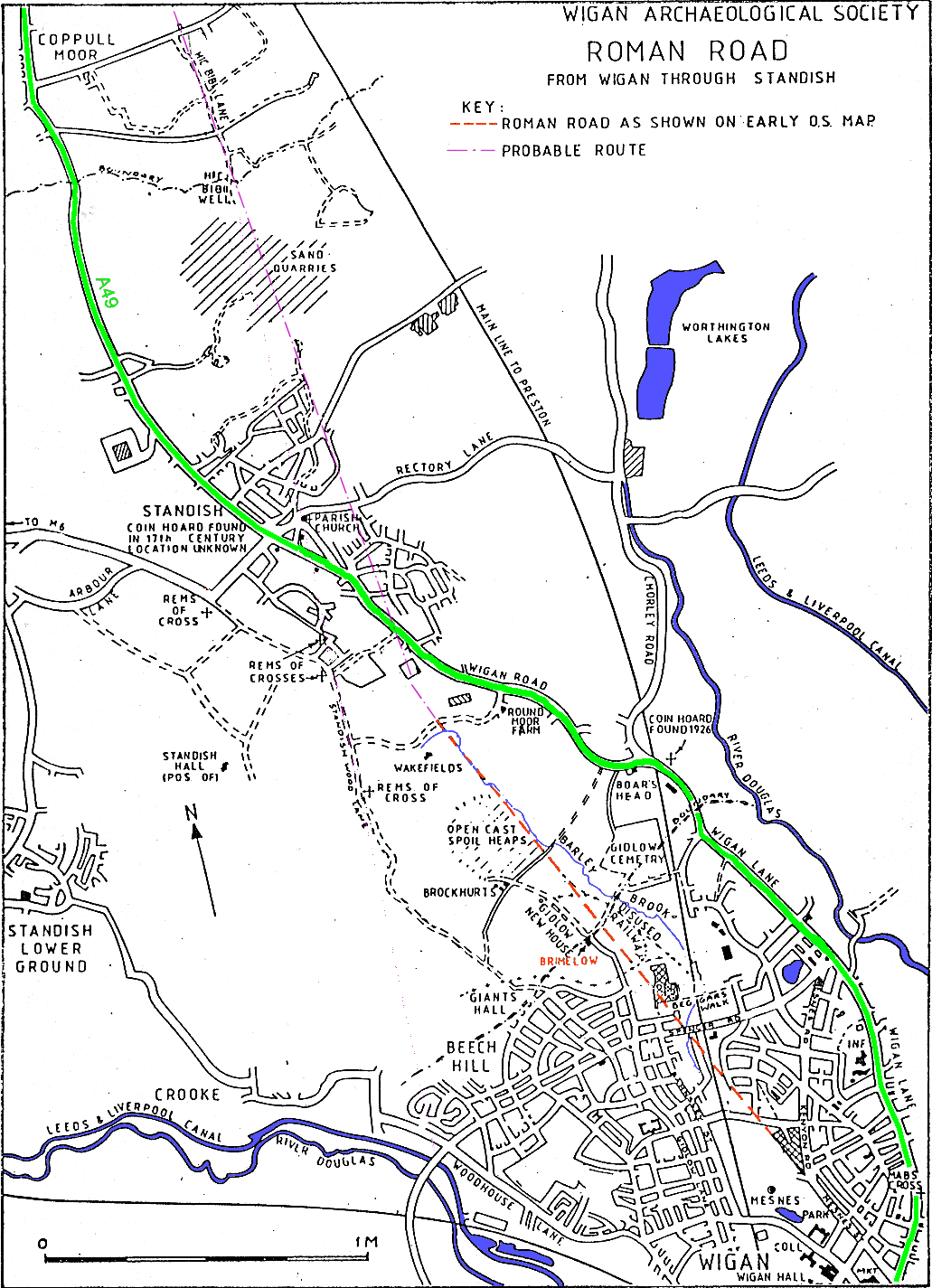
Brimelow Farm. Over the years ours Society have carried out a number investigations in the two fields at Brimelow including geophysical surveys and excavations. In 1988 our excavation found evidence for the road in the north field showing it to be about 8 metres wide composed of compacted river cobbles with a possible ditch on the west side. In 2004 we confirmed the alignment by finding further evidence in the south field (as reported in Newsletter 75). This time the road appeared to be 9 metres wide but no roadside ditches could be detected. You can see full details of our 2004 investigations here.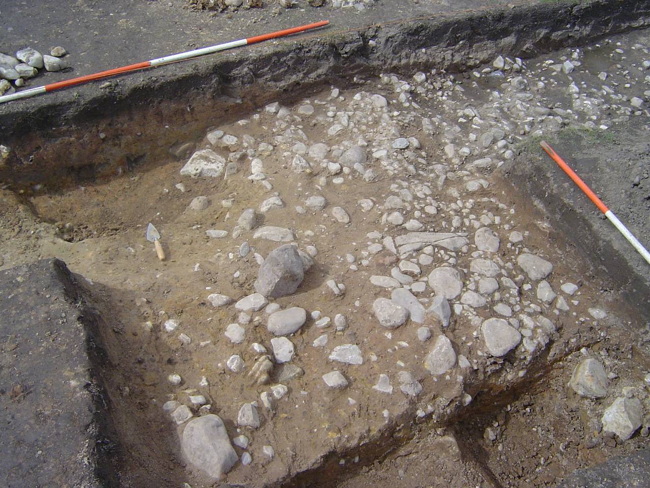
Ground Penetrating Radar. At the time we struggled to detect the road in the south field (despite many attempts) using our resistivity equipment. However in 2016 we were able to get access to GPR equipment and so returned to Brimlow to see if it could detect the road where we knew it existed thus proving its effectiveness of this prospecting tool. The result was a success and we were also able to detect other features away from the alignment and the farmer Roy Brandon has kindly allowed us to investigate these too (using this equipment the we able to successfully detect a section of road for the Wyre group near Garstang – Newsletter195). You can see details of our 2016 survey at Brimelow Farm here
GM Festival of Archaeology. In 2018 we got the chance to investigate the anomalies we had detected with more excavations as part of this yearly festival. The features away from the alignment proved to be nothing more than recent disturbance but test pits on the alignment once again exposed the road. This time the road proved to be 10 metres wide but, as with the 2004 excavation, no side ditches could be detected. You can see details of our 2018 excavations here
Standish Wood Lane. Further north Thomas Codrington favoured this road in his book “Roman Roads in Britain”. On what evidence he does not say but this old road is a popular choice with many historians. It is unarguably an ancient track as there are three Medieval cross bases located along its route. Recently Edmund Wadelove (Britannia XXXII 2001) cites this route because of its alignment with the known Roman road from Wigan to Warrington that runs south of Wigan on the other side of the Douglas valley. Wadelove concludes that Standish is the Roman settlement of Coccium (however this was before the discovery of the Roman bathhouse in the centre of Wigan). It is quite understandable, when examining this route on the ground, why historians have been attracted to it, as it is quite straight and follows a natural ridge south out of Standish.
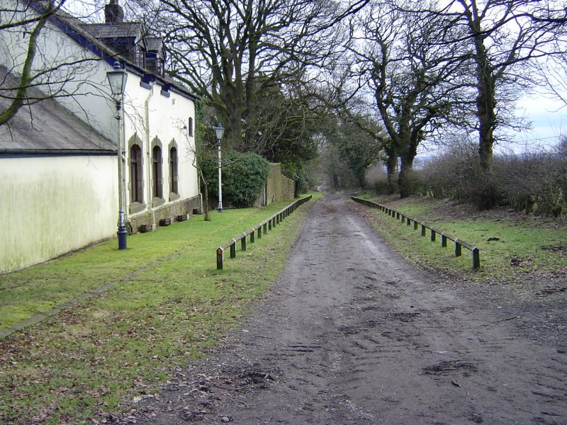
Looking south along Standish Wood Lane as it passes Strickland House
Along a portion of its length, however, the road turns into a 4 metre deep hollow way which suggests a medieval origin (one of the Medieval cross bases is located part way along this section – adding credence to this suggestion). If, however, we consider the hollow way section to have been a later addition to alleviate the steep slope at that particular point, it is still possible to imagine this route as being the original Roman alignment (the route into Wigan via Brimelow Farm being a later diversion). To check this theory, in 2009 and 2010 the Wigan Arch Soc carried out fieldwork in this area including two resistivity surveys in fields either side of Lower Standish Wood Fold (now called Speckled Holly) on the projected line. The results however were negative. The lack of pottery in the south filed suggests it was not cultivated until recent times, which would give more chance for the road to survive if it was there. Our only conclusion is that, from these results, the road did not cross these fields and therefore Standish Wood Lane is unlikely to have been the Roman road. You can see details of our investigations here .
Row High Wood. In 2016 a section of the road just north of Coppull was suggested by David Ratledge after examining LiDAR images of the area. To check this out we visited the site and you can see details of what we found here
Hi…We are currently investigating the possibility of a Roman road/ Track coming from the Wigan area towards our home town of Burned then towards Ilkley.
Could anyone possibly be able to she any light on this please.
Kind regards Dave Pendle Archaeological Society
Sorry my home town is infact Burnley.
Thankyou
Dave
Hi Dave – we are quite sure there was a road from Wigan to Ribchester (which corresponds to the information in the Antonine Itinerary – 20mp from Wigan) although we haven’t found anything specific on the ground. There is a well established route from Ribchester through Clitheroe, Barnoldswick and on past Skipton, but I haven’t come across one going toward Burnley. I’d be very interested any information you have on this route.
Bill Aldridge
I live near to A49 North of Wigan. I always assumed that this was the old main road through Lancashire via Wigan.
When did it change from the Roman/Medieaval road to it`s present position?
Excavations at Walton-le-Dale in the 1990’s revealed a very impressive section of this particular Roman road. It’s heading going south was directly towards Todd Lane in Lostock Hall and Stanifield Field just north of Leyland. The projected line from there lines up quite nicely with the A49 at the Pack House Bridge (south of Buckshaw village). Incidentally the twist in the A49 here seems to have been there before the railway came. It seems quite likely that the Roman road followed the A49 south from here all the way through Euxton as far as the Bowling Green pub on the south side of the Yarrow valley. From here its line becomes vague until we pick it up again just south of Coppull. It crossed Coppull Moor Lane on an alignment with Hic Bibi Lane where Chorley Arch Soc excavated in the 1980’s. At this point the line is some way east of the A49 but crosses it at Standish to line up with the section we investigate at Brimlow Farm. Not at all sure when this section was abandoned in favour of the A49 but I do know that it was earlier than the Middle Ages as there exists a reference to the Boars Head pub on the highway leading out of Wigan. Hope this helps.
Bill Aldridge
Thanks. The main reason that I am asking is that as I understand it, the Battle Of Wigan Lane in 1651 was known as the Battle of the Bloody Mountains and resulted in the Royalists and Parliamentarians meeting along the road.
I seem to remember that some time ago I read that the area was recorded on maps as being theBloody Mountains before 1651.
Also, that Bottling Wood may have been a corruption of Battling Wood.
A book in the History Shop at Wigan about the history of Wigan states that 4 of the 12 battles of King Arthur may have been fought on the banks of the Dhub Glas or Douglas. That Wigan may derive from Wig meaning fight and an making it plural, therefore, place of fights or battles.
I did read that Vig is fight in Norse.
I also understand that the description of the 4 battles is that they were fought in the Region of Linnuis or the Region of the Lake and that the Lake may be Martin Mere.
If so, then the battles may have been fought taking the road into account etc as was the 1651 battle, and if so then the road would possibly have been along the current A49 when Arthur fought the Anglo-Saxons etc.
Could it be that the Roman Road went out of use when the Romans left Britain etc?
Would the Romans have chosen the path of the Roman road to fit into their road building patterns rather than follow higher ground etc. and that when they left the locals began to use higher ground etc.?
The Roman road north of Wigan may well have gone out of use quite early -because, as you suggest, the locals may have preferred the higher ground.
As for the King Arthur’s battles, it was Whitaker (an 18th century historian from Manchester) who suggested that the 2nd, 3rd, 4th and 5th were fought in the Wigan area. He linked them to the discovery of a large quantity of human and horse remains found when the Terminal Basin was built at the bottom of Wallgate (more details of this in our Q and A section which you can find here http://www.wiganarchsoc.co.uk/QandA.html#4
I’ve also come across the term Wig meaning to fight as being the origin of Wigan’s name. We explore this and other possibilities in an early newsletter (No. 15 http://www.wiganarchsoc.co.uk/content/News_Letters/news015.htm
I must admit I haven’t come across any reference to the Bloody Mountains prior to the 1651 battle – but strangely enough the site is marked on the 1849 6″ OS map in the Bottling Wood area. This is on the other side of the Douglas Valley to where the actual battle took place which was quite definitely on Wigan Lane (by the maps of the Wigan area prior to the Civil War are quite rare – the only two I know of, Gough’s (1360) and Speed’s (1610) don’t have the reference).
Arthur’s 10th battle of Tibuit (Latin) or Traeth Tryfrwyd (British).
In the ongoing discussions concerning the possible site of Arthur’s tenth battle of Tribuit, the River Ribble area receives mention. On the banks of the Douglas, a tributary to the Ribble estuary, lies the village of Rufford.
The British term for this battle is Traeth Tryfrwyd. Rufford and (T)ryf(r)wyd sound remarkably similar.
Traeth means ‘estuary’. While Rufford is now several miles from the present Ribble estuary in earlier days it was perhaps the first upstream settlement?
Just a thought.
In Roman mythology, the goddess Minerva had an owl.
The emblem of Standish/the Standish Family included an owl.
If the head of the goddess Minerva was found North of Wigan, is there any connection ?
Could be but I haven’t heard of anybody finding the head of the goddess Minerva in Standish (that would be a find). By the way the Bloody Mountains reference only appears on the 1893 and 1907 OS maps to the south of Bottling Wood (not the 1849 map as previously mentioned) – in the area around West Mount and Vine Street.
I am writing a short history of Appley Bridge and would like to include your 1849 O.S. Map showing the possible line of the Roman Road. This is a totally none commercial venture and we expect only a few copies will be produced mainly to go to school and local community groups. You would be fully acknowledged.
Hi Stephen, unfortunately it’s only shown on the 1 inch OS map of 1840 but I’ll will send you that by E-mail (btw hope you are including something about the Meadows and the search for the Douglas Lock – http://www.wiganarchsoc.co.uk/content/News_Letters/news206.htm )