Chapters
|
Project: Standish Hall Corn Mill
(An Excavation carried out by the Wigan Archaeological Society)
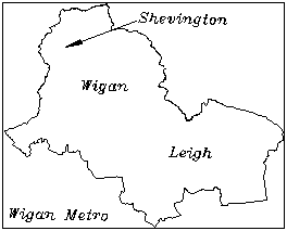 In 1989 British Coal sold Elnup Wood in Shevington to
the local Groundwork Trust for just a pound. The intention was to encourage the locals to
get involved in a wood management scheme, providing a useful amenity for the surrounding
community. Later that year, Friends of Elnup was formed. One member, Adrian Morris, was
assigned with the task of researching the wood from a historical point of view and he soon
realised there had been a corn mill in the valley which belonged to Standish Hall Estate.
From his subsequent research of this and of another mill in the area (the Jolly Mill),
Adrian produced a booklet entitled Standish Corn-Mills and Millers, which was published in
1995 by Landy Publishing. In 1989 British Coal sold Elnup Wood in Shevington to
the local Groundwork Trust for just a pound. The intention was to encourage the locals to
get involved in a wood management scheme, providing a useful amenity for the surrounding
community. Later that year, Friends of Elnup was formed. One member, Adrian Morris, was
assigned with the task of researching the wood from a historical point of view and he soon
realised there had been a corn mill in the valley which belonged to Standish Hall Estate.
From his subsequent research of this and of another mill in the area (the Jolly Mill),
Adrian produced a booklet entitled Standish Corn-Mills and Millers, which was published in
1995 by Landy Publishing. |
| History
In his book Adrian describes historical documents and deeds that
provide good evidence for a mill in the valley as early as the 14th century. The mill,
however, is only first mentioned by name in the 18th century in an account book by Ralph
Standish. This shows that the miller Ralph Rainford paid rent for the mill between 1721
and 1727. Documents show that in the 19th century the mill was owned by Stephen
Richardson, who also farmed land in the Shevington area. By 1871, however the family had
moved to Appley Bridge and, at that time, no miller is documented in Shevington, which is
taken as an indication that the mill had gone out of use by then.
|
Maps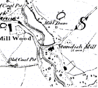
A pictorial representation of the mill is shown on a
manor map of 1763, depicting a large building standing parallel to a dam with an east wing
at right angles. Another wing is shown to the west (although this may have been a separate
building). The Standish Tithe Apportionment map of 1842 and the 1st edition 6 inch OS
map
of 1849 both show the mill to be about 28m long, including an additional extension to the
west which is shown slightly offset to the north. There are two wings as before extending
southwards from the main building. Later
maps of 1898 and 1826 have some inconsistencies
but generally show only the west extension still surviving. |
| Cottage
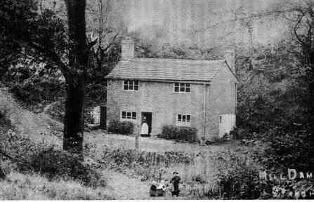
A photograph taken at about the turn of the century
shows only the west section, which had been converted into a two-storey dwelling. This
building survived up to just after WW2 when it was demolished due to its unsafe condition,
apparently without the absent owners permission. Much anecdotal information about this
cottage has come from people who lived there or who knew the people who lived there. For
instance how local children pestered the residence by putting sods over the chimney which
was easily reached from the bank of the milldam behind. Also the owner at one time had a fishpond
built where the mill building had been. [Click
here] to read an account from B Whittle who was born and lived there
before the War.
In early 90's, when Adrian first started his research, there was no
trace of any building or fishpond on the ground and nobody really knew exactly where the
mill had stood. The large earth bank representing the milldam still straddled the valley
with a footpath across the top. The water was gone from the millpond, drained through a
well built stone cut sluice on the west side of the dam, but this was well away from where
the mill site was supposed to be.
|
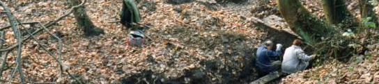
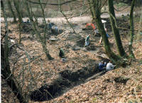
| Excavation.
It was at this point that Adrian decided to contact the Archaeological
Society to see if we could identify on the ground the precise position of the mill. When
we first arrived in 1993, the ground in front of the milldam was completely overgrown and
very boggy. Water from a small spring on the east side of the valley was constantly
running on to the site and the first job was to channel this away to allow the area to dry
out.
| Cutting through the undergrowth, the outline of a small brick building
was soon revealed, which turned out to be the remains of a cottage shown in the
photograph. As we had suspected it had two rooms with a hearth in the middle of the west
gable wall and a small oven structure in the north east corner of the other room. | 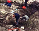 |
 The rest of the mill itself proved more illusive. However Groundwork were
able to provide a small excavator, and by digging a series of trenches eventually the mill
foundations began to emerge. They lay approximately one meter below the present ground
level, buried beneath a thick layer of rubble in-fill. This was sealed below a layer of
black sticky clay, which was in turn covered by a rich deposit of topsoil. The topsoil, we
believe, had come from the adjacent fields, which had been open cast in the 1950's causing
alterations in the field drainage. The black sticky clay turned out to be puddling clay
put down by the owner of the cottage when creating a fishpond in his garden. The rubble
in-fill was a mixture of brick, ash and domestic refuse containing pottery dating from the
19th century. It seemed obvious that after the mill had been demolished, the remaining
hollow was used as a rubbish midden.
The rest of the mill itself proved more illusive. However Groundwork were
able to provide a small excavator, and by digging a series of trenches eventually the mill
foundations began to emerge. They lay approximately one meter below the present ground
level, buried beneath a thick layer of rubble in-fill. This was sealed below a layer of
black sticky clay, which was in turn covered by a rich deposit of topsoil. The topsoil, we
believe, had come from the adjacent fields, which had been open cast in the 1950's causing
alterations in the field drainage. The black sticky clay turned out to be puddling clay
put down by the owner of the cottage when creating a fishpond in his garden. The rubble
in-fill was a mixture of brick, ash and domestic refuse containing pottery dating from the
19th century. It seemed obvious that after the mill had been demolished, the remaining
hollow was used as a rubbish midden.
|
| Phases
By 1996, working only at weekends in the summer, the Society was able
to uncover a number of buildings, representing four separate phases of construction. The
earliest phase, we believe was to the east and must be the actual mill building itself. A
corn-drying kiln was the next to be constructed representing the west wing shown on the
early maps. A brick annexe was then built in the corner between the kiln and the mill.
Finally the west extension (cottage) was added, using the west wall of the annexe as its
east gable end and part of the back wall of the kiln. When the mill and kiln buildings
were demolished toward the end of the last century, the west extension was left, retaining
parts of the annex and kiln building in its construction.
|
| Drying Kiln
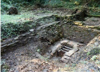 The most interesting building uncovered was the corn-drying
kiln, which was a large brick building constructed on stone foundation walls 0.5 metre
thick. The building was 9.1 metres long by 5.5 metres wide. Built internally against three
sides of the stone wall foundations, we found brick terracing about 1 meter high and 1
metres wide. In the centre was a large brick built hearth, which still had three iron bars
for the fire. Originally, over this terracing, there would have been a large tiled floor
supported by a cast or wrought iron frame. In the drying operation, corn would have been
spread over the tiles, which had perforations in them to allow the heat from the fire to
percolate through. When the kiln was in operation there would have been a large iron plate
suspended under the iron floor just above the fire to prevent scorching the grains. The most interesting building uncovered was the corn-drying
kiln, which was a large brick building constructed on stone foundation walls 0.5 metre
thick. The building was 9.1 metres long by 5.5 metres wide. Built internally against three
sides of the stone wall foundations, we found brick terracing about 1 meter high and 1
metres wide. In the centre was a large brick built hearth, which still had three iron bars
for the fire. Originally, over this terracing, there would have been a large tiled floor
supported by a cast or wrought iron frame. In the drying operation, corn would have been
spread over the tiles, which had perforations in them to allow the heat from the fire to
percolate through. When the kiln was in operation there would have been a large iron plate
suspended under the iron floor just above the fire to prevent scorching the grains.
 A good working example of a mill of this type is at the
Heron Mill near
Milnthorpe in Cumbria. The corn-drying kiln is still intact and you can see sloping terracing under
the tiled floor, which is on 3 sides in a similar
fashion to ours. On the fourth side there is a large
wooden board which slopes toward the fire. At the front of this are large wooden hoppers
where the grain is pushed after drying, to be loaded into sacks ready for milling. A good working example of a mill of this type is at the
Heron Mill near
Milnthorpe in Cumbria. The corn-drying kiln is still intact and you can see sloping terracing under
the tiled floor, which is on 3 sides in a similar
fashion to ours. On the fourth side there is a large
wooden board which slopes toward the fire. At the front of this are large wooden hoppers
where the grain is pushed after drying, to be loaded into sacks ready for milling. |
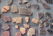
| Tiles
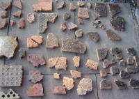 Many of the perforated tiles
that have found on the site are mostly large well-made moulded types (25cm square x 5 cm deep) with some 5-hole but mainly 9-hole
cluster patterns. These, we believe, date from the early 19th century. However, many were found which were obviously hand-made with only a one hole or 3-hole pattern and must
therefore be older. Some of these had been reused in the construction of the kiln particularly in the area between the terracing and the hearth. One 3-hole type was sent to
Bolton Museum Services for dating (they have a large brick collection for this purpose). From the condition of the fabric, their conclusion was that the tile
could beas early as the 16th century in
date. Although the mill is reputedly to Medieval in date
and a great quantity of pottery was retrieved from the site, these kiln tile
fragments proved to be the oldest items identified. Many of the perforated tiles
that have found on the site are mostly large well-made moulded types (25cm square x 5 cm deep) with some 5-hole but mainly 9-hole
cluster patterns. These, we believe, date from the early 19th century. However, many were found which were obviously hand-made with only a one hole or 3-hole pattern and must
therefore be older. Some of these had been reused in the construction of the kiln particularly in the area between the terracing and the hearth. One 3-hole type was sent to
Bolton Museum Services for dating (they have a large brick collection for this purpose). From the condition of the fabric, their conclusion was that the tile
could beas early as the 16th century in
date. Although the mill is reputedly to Medieval in date
and a great quantity of pottery was retrieved from the site, these kiln tile
fragments proved to be the oldest items identified.
In 2004 the society was contacted by Peter Crew form the Snowdonia National Park Study Centre at Plas Tan
y Bwlch. Peter and his team have
been investigating kiln tiles for a number of years now and have built up
quite a large catalogue covering Wales and Cumbria. Their wide and varied
collection consists mainly of tiles dating from the 19th century but they do
have some earlier examples of which some are handmade.
They were, therefore, quite excite to see our collection, which consisted of
a good number of the hand-made type. We dully delivered our collection to
them later that summer while on a society trip to the centre (newsletter
76). Peter is currently adding them to his catalogue. His
opinion is that this batch of early hand-made examples are probably the most
important single collection in the country and represent continuous
operations on the site over many years.
|
Annex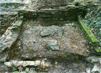
Some of the hand-made tiles were also found in the flooring of
the annex building, which had a raised cobbled area about 1 metre square in the centre.
Beneath this we hoping to find earlier remains, as it did not appear to be cellared,
however trial trenching to one side failed to show anything significant. The purpose of
this building still remains unclear. |
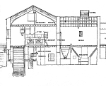
The Plan of the Excavated Site
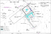
[Click
here] to see how the site could have looked in the late nineteenth
century |
| Future Work
Excavation towards the east of the site came to halt because of a large
crack willow, which, although having gained permission for it to remove, had not the necessary
funds to carry out the work. Also the depth of the remains
on this side would have required
hiring a much larger excavator. This is the area where we believe the wheel pit to be
located. Anecdotal information suggests that water came on to the wheel through a tunnel
in the dam wall. However, we could not find any evidence for this and it may be that the
water was channelled in a wooden chute or launder from the stone built sluice on the west
side of the dam.
The tailrace for the mill also went through a tunnel, the exit of which
was found when a large amount of dirty water was drained into the excavation. This
happened after a heavy down pour when water had collected in the another part of the
excavation. The water almost immediately disappeared, but re-emerged about 30 meters way
entering the stream, which runs through the open sluice to the west. The entrance to the
tunnel was never found.
It was the intention of the Groundwork Trust to build permanent fencing
around the site, and a viewing platform with information boards as part of general scheme
for a woodland trail. However maintaining an open site
would prove difficult and back filling was the best option for its long-term preservation.
There is still plenty of archaeology on this for future investigations. Bill Aldridge
Wigan Archaeological Society |
|