Chapters
|
Project: Arley Hall & Water Mills
Research by the Wigan Archaeological Society Grid Ref: SD589107
The society has been studying the Arley Estate and the nearby Douglas
valley for a number of years now, trying to unravel some of the complex
historical and industrial activities that have gone on there over the
centuries. Here is our report.
|
|
Arley Hall
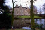 For the last hundred years or so Arley Hall has been the headquarters of the
Wigan Golf Club, a private course on the outskirts of Blackrod. Strictly
speaking it lies in the Bolton Metropolitan Borough, but the Hall has had
a long history associating it strongly with the Wigan area. For the last hundred years or so Arley Hall has been the headquarters of the
Wigan Golf Club, a private course on the outskirts of Blackrod. Strictly
speaking it lies in the Bolton Metropolitan Borough, but the Hall has had
a long history associating it strongly with the Wigan area.
(click here for more details)
(click here for details of site
map)
|
| History
First mention of an estate at Arley
seems to come from the 12th
century when it was reported that King Henry I confiscated it (later to be
returned by King John (1)). The earliest reference to its occupancy comes
for the 13th century when the le Walsh family are mention in local charters. As
early as 1190 the surrounding manors of Haigh and Blackrod were apparently in the hands
of the le Norreys family and it is possible that Emma, sister of Hugh le
Norreys, held Arley in 1290 (2). However, when William le Walsh died in
1393, deeds mention that he held land at Arley, renting it for one penny or
a pair of gloves from William le Bradshagh, who by then was lord of the
manor (2) (William's predecessor, William Bradshaigh of the Mab's
Cross Legend, had married Mabel Norris some time in the late 13th
century).
From the early 15th century to the late 16th century a
branch of the Standish family were in residence, possibly the same 'Arley'
branch who founded the Chantry of the Holy Cross in Standish Parish Church
(3). In 1442 James Standish of Arley was charged with 'waylaying certain
persons in order to kill them'. His brother Oliver and others were also
implicated (2).
In the 17th century details are less certain, but by the
middle of the 18th century we know that the Chisenhale family had been
established there. The Rev. John Chisenhale owned coal mines in the area and
it was he who was responsible, in 1767, for rebuilding the hall. He died at
the Hall in 1782,  followed by Daniel, his younger brother, in 1798. This
left the estate in the hands of the reverend's daughters, Ann and Hannah
(4). Ann was already married to a John C. Johnson of Liverpool who later
took the Hall as his seat. They had two sons, John and William, who assumed
the Chisenhale name. John later became Deputy-Lieutenant for the county. In
1800, while cleaning out the moat, their father is reported to have found a
quantity of medieval silver possibly dated to Henry II (3), which supposedly
ended up in the British Museum. Further inquiries by the author at the BM
have drawn a blank. In the BM's opinion the find, in all probability, was a
collection of late Elizabethan or early Jacobean pewter. Three candlesticks
from the collection in fact were put on view at a pewter exhibition held at
Lincoln's Inn, London in 1904 and 1908 (5) . The whereabouts of these items
are now unknown. followed by Daniel, his younger brother, in 1798. This
left the estate in the hands of the reverend's daughters, Ann and Hannah
(4). Ann was already married to a John C. Johnson of Liverpool who later
took the Hall as his seat. They had two sons, John and William, who assumed
the Chisenhale name. John later became Deputy-Lieutenant for the county. In
1800, while cleaning out the moat, their father is reported to have found a
quantity of medieval silver possibly dated to Henry II (3), which supposedly
ended up in the British Museum. Further inquiries by the author at the BM
have drawn a blank. In the BM's opinion the find, in all probability, was a
collection of late Elizabethan or early Jacobean pewter. Three candlesticks
from the collection in fact were put on view at a pewter exhibition held at
Lincoln's Inn, London in 1904 and 1908 (5) . The whereabouts of these items
are now unknown.
In 1865 James Gidlow, a local mill owner, bought the Hall
for �13,000, with the intention of exploiting the coal in the area (6).
When he died, the estate went to a Colonel Fell, J.P. of Bolton. It was at
this time (1898) that the grounds were converted into the golf course with
the Hall becoming the clubhouse and HQ. A book has recently been published
to celebrate the club's centenary. Written by Jack Winstanley, it covers in
detail this period to the present time, particularly of how the estate was
acquired by the club, which in itself is a fascinating story. (The book can
be viewed at the Wigan History Shop, library reference 796.35209.42736).
(1) The Journal (Bolton) 28th Jan 1888
(2) Victoria County History (Lancashire)
(3) Wigan Observer and Advertiser 5th June 1909
(4) Last Will & Testament of Daniel Chisenhale 1798 (Preston Record Office)
(5) Candlesticks (from 13th to 19th Century) - Ronald F Michaelis
(6) Wigan Golf Club Booklet 1928
|
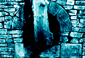
| Water Mill
About half a mile away from the Hall, in the wooded
valley which borders the grounds to the north and west, lie the remains of
a water mill. The site can be seen by taking a detour to the left from the
 present path which leads from the hall to the footbridge over the river
Douglas. The ruins are perched precariously on the hillside in the corner
where the Arley brook joins the Douglas and probably date from around the
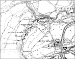
end of the 18th century. They appear on the tithe map of 1841 and also on
the first edition six inch Ordnance Survey map of 1849 where the
site is marked as 'Arley Mill (Logwood)'. The only reference we have been
able to discover about the activity carried out at the mill appears in a
Wigan Observer article in 1915, where it says 'fustic and charcoal being
ground there, on a machine called a raft' (7). Logwood and fustic were
types of wood imported from the Americas and ground down to extract black
and yellow dyes for the clothing industry. On the ten inch (1892) and six
inch (1909) Ordnance Survey maps the Arley Mill is shown as an abandoned
ruin with two pit shafts adjacent. On the 1930 Geological Survey map, the
site is marked as 'Arley Mill Pit', the shafts of which had been sunk to a
depth of 1044 feet. On the ground, two depressions mark the position of
the two mineshafts with the remains of protective fencing provided by the
National Coal Board. The closeness of the shafts to the mill tends to
suggest that waterpower was being used in the mining operation, possibly
winding or pumping. If this is the case, it is a rare example of a mining
practice which died out soon after the advent of steam power.
present path which leads from the hall to the footbridge over the river
Douglas. The ruins are perched precariously on the hillside in the corner
where the Arley brook joins the Douglas and probably date from around the
end of the 18th century. They appear on the tithe map of 1841 and also on
the first edition six inch Ordnance Survey map of 1849 where the
site is marked as 'Arley Mill (Logwood)'. The only reference we have been
able to discover about the activity carried out at the mill appears in a
Wigan Observer article in 1915, where it says 'fustic and charcoal being
ground there, on a machine called a raft' (7). Logwood and fustic were
types of wood imported from the Americas and ground down to extract black
and yellow dyes for the clothing industry. On the ten inch (1892) and six
inch (1909) Ordnance Survey maps the Arley Mill is shown as an abandoned
ruin with two pit shafts adjacent. On the 1930 Geological Survey map, the
site is marked as 'Arley Mill Pit', the shafts of which had been sunk to a
depth of 1044 feet. On the ground, two depressions mark the position of
the two mineshafts with the remains of protective fencing provided by the
National Coal Board. The closeness of the shafts to the mill tends to
suggest that waterpower was being used in the mining operation, possibly
winding or pumping. If this is the case, it is a rare example of a mining
practice which died out soon after the advent of steam power.
(7) Wigan Observer 10th June 1915
|
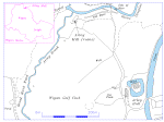
| Survey
 Although much of the mill's remains have survived over
the years, the effects of vegetation and wear and tear from visitors have
taken its toll. It was with this in mind that from 1993 to 95 the Wigan
Archaeological Society carried out a survey of the site, in order to
record as much detail as possible before further deterioration took place.
A certain amount of clearing had to be done before work could start,
however, great care was taken not to disturb the fragile nature of the
surviving structures. Although much of the mill's remains have survived over
the years, the effects of vegetation and wear and tear from visitors have
taken its toll. It was with this in mind that from 1993 to 95 the Wigan
Archaeological Society carried out a survey of the site, in order to
record as much detail as possible before further deterioration took place.
A certain amount of clearing had to be done before work could start,
however, great care was taken not to disturb the fragile nature of the
surviving structures.
From the remains it was found that the building was
rectangular in shape and constructed mainly of roughly cut sandstone, with
some dressed blocks for 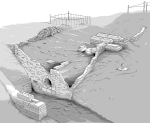 corner
quoining. Huge blocks of sandstone were
located in a number of areas within the structure, carefully cut to mount
heavy machinery. The building measured 9.75 metres wide, but its length
could not be determined precisely as the walls only survive on three
sides. There was, however, evidence of a dividing wall running at 7.3
metres from the north wall. There are indications that the mill was
probably quite a high structure, as two large brick built buttresses have
been added at some time on the outside of the west wall. corner
quoining. Huge blocks of sandstone were
located in a number of areas within the structure, carefully cut to mount
heavy machinery. The building measured 9.75 metres wide, but its length
could not be determined precisely as the walls only survive on three
sides. There was, however, evidence of a dividing wall running at 7.3
metres from the north wall. There are indications that the mill was
probably quite a high structure, as two large brick built buttresses have
been added at some time on the outside of the west wall.
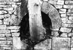
Judging from the size of the wheel pit, the actual
water wheel would have been huge. Measurements indicate it would have been
5.5 metres in diameter and 2.75 metres wide. The water approached the
wheel through a stone-lined tunnel from the millrace. By comparing the
height of the tunnel roof with the central axis of the wheel, the
indication is that the 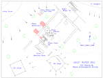 mill was breast shot (i.e. water came onto the
wheel at its centre). This was confirmed by further study of the millrace,
which showed that water could not have filled to a higher level than the
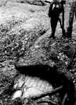
top of the tunnel. The remains of the millrace itself can be traced back
to the river Douglas about 150 metres upstream, where evidence of the weir
or dam can still be seen in the riverbank. The sluice gate timbers also
survive at the entrance to the millrace (see Excavations
below).
mill was breast shot (i.e. water came onto the
wheel at its centre). This was confirmed by further study of the millrace,
which showed that water could not have filled to a higher level than the
top of the tunnel. The remains of the millrace itself can be traced back
to the river Douglas about 150 metres upstream, where evidence of the weir
or dam can still be seen in the riverbank. The sluice gate timbers also
survive at the entrance to the millrace (see Excavations
below).
It is obvious, when looking at the remains of the mill,
that it was a crushing operation rather than a grinding one, as the stone
wheels, which are still to be seen among the rubble, have smooth edges and
rough faces. The largest measures 1.83 metres in diameter by 0.36 metres
thick and would have been mounted vertically in pairs, driven round a
third wheel lying horizontally. One of the vertical wheels is still in one
piece, whereas the other has been smashed into at least three pieces and
is lying nearby. The base 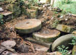 wheel is still in its original position mounted
on a large stone plinth. Another smaller wheel (1.3 metres diameter by 0.3
metres thick) survives complete with its iron shaft, lying outside the
building to the west. At present there is nothing to indicate where this
wheel would have been mounted. wheel is still in its original position mounted
on a large stone plinth. Another smaller wheel (1.3 metres diameter by 0.3
metres thick) survives complete with its iron shaft, lying outside the
building to the west. At present there is nothing to indicate where this
wheel would have been mounted.
Adjacent to the grinding wheels inside the mill is a
curious stone lined pit, which seems to be in line with the drive shaft of
the water wheel. It measures 0.95 metres square and 0.9 metres deep with a
stone lined bottom. The inside walls bear the marks of something which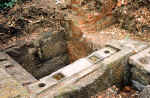 rotated on a vertical axis. Cut stone beds indicate where the bearings
would have been mounted, held down by large iron tie rods. Adjacent to
this feature are two very large stone machine beds which seem to be in
line with the pit shaft next to the mill building. The inference is that
waterpower was being used for either winding or more likely pumping (all
the pits in this area were notorious for flooding).
rotated on a vertical axis. Cut stone beds indicate where the bearings
would have been mounted, held down by large iron tie rods. Adjacent to
this feature are two very large stone machine beds which seem to be in
line with the pit shaft next to the mill building. The inference is that
waterpower was being used for either winding or more likely pumping (all
the pits in this area were notorious for flooding).
We could find no evidence of steam power on the site
except for a chimney marked on the 1909 1/2500 map. It may be, therefore,
that the mill was abandoned when the wheel stopped working sometime
between 1850 and 1870.
|
| Mill Research
The earliest reference to the mill at 'Erelegh' comes
from the 13th century when it seems likely the le Walsh family where in
residence at the Hall(2). Later, according to the Standish deeds of 1559/60
,"..Christopher Worthington grants a licence to James de Standish of
Erley to erect a mill dam and smithy on the Douglas water.."(8). It is
probable that this refers to a corn mill, although nothing appears on the
Yates Map of 1786. This may be an omission or perhaps the site had gone out
of use as a corn mill by then.
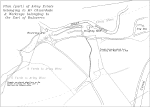 A few years ago Tony France, a mining consultant and
local historian, drew our attention to an estate plan showing two
mills in the Arley valley, the extant one being marked as the Blacking Mill
and the additional one, further up the valley, as the Doughty Mill. The plan
was probably drawn by William Peace the mining agent for the Earl of
Balcarres (Lord Crawford), who, in the 1830's, was in dispute with Mr
Johnson of Arley over mineral rights and mine drainage (9). A few years ago Tony France, a mining consultant and
local historian, drew our attention to an estate plan showing two
mills in the Arley valley, the extant one being marked as the Blacking Mill
and the additional one, further up the valley, as the Doughty Mill. The plan
was probably drawn by William Peace the mining agent for the Earl of
Balcarres (Lord Crawford), who, in the 1830's, was in dispute with Mr
Johnson of Arley over mineral rights and mine drainage (9).
There was no sign of this second mill on the ground,
however, further research revealed that the census for 1841 had a miller
living at the Blacking Mill and a collier's family living at the 'Dooty'
Mill. This may indicate that the second dwelling had stopped being used as a
water mill by then. The only other map we could find, which shows both
buildings, is the Blackrod tithe map from the same year as the census.
Careful study of the 1849 first edition map shows another 'blacking' mill on
the same stretch of the Douglas, about a mile upstream towards Addlington.
Although other 'blacking' mills can be found around Lancashire, the actual
process being carried out has not been established. John Shaw, in his book
'Water Power in Scotland' describes a blacking mill as 'for the crushing of
Charcoal to a fine powder, which was then used to dust moulds in the iron
founding industry when it was at its heyday c1820'. It is interesting to
note that the site of the Haigh Foundry, famous in the 18th and 19th
centuries, is not that far away, just a mile or so down the Douglas valley.
(8) Calendar of Standish Deeds 1230-1575 - Porteus
(9) Wigan Coal & Iron Co. by Donald Anderson & A A France
|
| Excavations
In 1997 we set out to find the position of the second
'Doughty' mill and carry out a detailed survey of the millrace in that area.
On the estate map the race appears to run beneath the mill before running on
to feed the blacking mill further down stream. The race is clearly defined
in this area being stone-lined, two metres wide and over one metre deep. On
the south side the ground is very boggy and, despite extensive searching,
little trace of a building work could be found.
 However, on the side between
the race and the river, substantial stone foundations of the building were
discovered lying approximately 40 cm below the surface. The ground is much
drier on this side and the remains appeared to be covered in layers of river
gravel. They consist of foundations going down to a depth of over a metre
surrounding a brick floor running level with the top of the millrace. A
bricked-up entrance on the east flank indicated different phases of
construction. Currently, only the east and north edges of the building have
so far been uncovered but the closeness of the north wall to the millrace
(approximately two metres) confirmed that the mill must have straddled the
race. The only dating evidence for the mill has come from the early 19th
century and nothing has been found particularly to indicate the building's
usage. The position, however, of the remains suggests that the mill must
have had an undershot wheel, as at this point on the race the head of water
would not have been high enough for anything else. Also the tailrace must
have followed a different route than at present to allow the water to be
discharged effectively. Just to the west of the remains, there is a branch
from the main race which leads straight into the river. It is probable that
this was the original route, modified when the second mill was constructed.
Clearing the area around the branch has shown that, in its present form,
this second race was being used as an over-spill for the main race, probably
to control the flow of water to the mill further down stream.
However, on the side between
the race and the river, substantial stone foundations of the building were
discovered lying approximately 40 cm below the surface. The ground is much
drier on this side and the remains appeared to be covered in layers of river
gravel. They consist of foundations going down to a depth of over a metre
surrounding a brick floor running level with the top of the millrace. A
bricked-up entrance on the east flank indicated different phases of
construction. Currently, only the east and north edges of the building have
so far been uncovered but the closeness of the north wall to the millrace
(approximately two metres) confirmed that the mill must have straddled the
race. The only dating evidence for the mill has come from the early 19th
century and nothing has been found particularly to indicate the building's
usage. The position, however, of the remains suggests that the mill must
have had an undershot wheel, as at this point on the race the head of water
would not have been high enough for anything else. Also the tailrace must
have followed a different route than at present to allow the water to be
discharged effectively. Just to the west of the remains, there is a branch
from the main race which leads straight into the river. It is probable that
this was the original route, modified when the second mill was constructed.
Clearing the area around the branch has shown that, in its present form,
this second race was being used as an over-spill for the main race, probably
to control the flow of water to the mill further down stream. 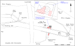 There is
evidence of perhaps even another millrace running beyond this branch
parallel with the river but its purpose is unclear. The river gravel, which
lies on top of the mill's ruins, is an indication that the other mill must
have continued in use well after this mill had been demolished, as race
debris must have been periodically cleared out and dumped on the side.
There is
evidence of perhaps even another millrace running beyond this branch
parallel with the river but its purpose is unclear. The river gravel, which
lies on top of the mill's ruins, is an indication that the other mill must
have continued in use well after this mill had been demolished, as race
debris must have been periodically cleared out and dumped on the side.
Subsequent work carried out here has involved clearing
the entrance to the millrace, which revealed quite a substantial amount of
timberwork underlying a thick layer of river gravel, which, in turn, was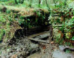 buried beneath layers of black sedimentary soil. Vertical sluice guides and
side and bottom lining timbers measuring 30 cm by 5 cm thick and up to 2
metres long were uncovered in an excellent state of preservation. This is
probably due to the damp anaerobic sedimentary environment in which they
reside. The sluice gate itself was also found nearby but has suffered far
more degradation, being closer to the surface, and only a small section of
it has survived. Further study of the overflow at the start of the millrace
branch has revealed an iron pipe approximately 15cm diameter. This could be
the outflow from the drainage tunnels marked on the early estate map.
buried beneath layers of black sedimentary soil. Vertical sluice guides and
side and bottom lining timbers measuring 30 cm by 5 cm thick and up to 2
metres long were uncovered in an excellent state of preservation. This is
probably due to the damp anaerobic sedimentary environment in which they
reside. The sluice gate itself was also found nearby but has suffered far
more degradation, being closer to the surface, and only a small section of
it has survived. Further study of the overflow at the start of the millrace
branch has revealed an iron pipe approximately 15cm diameter. This could be
the outflow from the drainage tunnels marked on the early estate map.
In the future, we would like to establish the full extent
of the Doughty mill and also try to discover where the bridge over the
millrace was located. We also intend to carry out more work in the general
area, hopefully to build up a full picture of industrial activity in this
unique valley. |
Bill Aldridge
Wigan Archaeological Society
Acknowledgement:
Ed Walmesley, Hon Secretary Wigan Golf Club, Arley Hall, Haigh, Wigan.
|
|