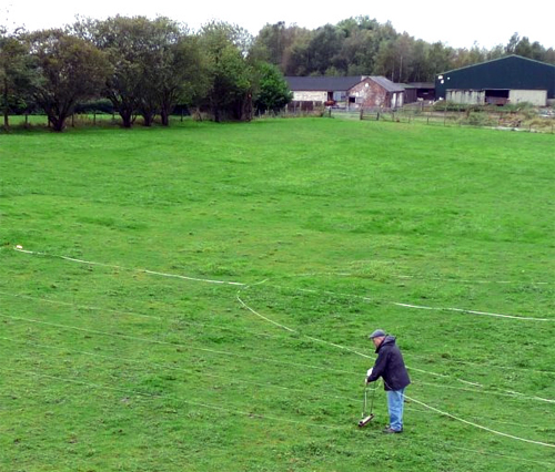
Last month we successfully completed our first survey at Cleworth Hall. Using the Society's resistivity meter, we were able cover a 51m x 20m patch across the middle of the field to the east of Cleworth Hall Farm. This is where we suspect the line of the Roman road to run (see our March Newsletter No.142 for details).
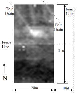 As is very often the case with resistivity, the results are a bit inconclusive. However, a high reading in the centre could be interpreted as the remnant of the road. Unfortunately, as it does not continue across the full width of the survey area, it is difficult to be certain of this interpretation. A dark band just to the north of it however is more linear and could represent the road side ditch. Other anomalies can be more easily indentified, e.g. two diagonal lines on the north side probably represent field drains. Also the linear feature running east-west across the middle of the survey area indicates the position of the fence line. The large dark patch to the south is more difficult to explain. This represents an area of low resistivity, which is an indication of high moisture content in the subsoil. This is contrary to expectations as the ground tends to rise in this area. The result could be due to a manmade feature such as a filled-in ditch but this would be huge - something you would normally expect from an ancient feature such as an Iron Age settlement. This is not totally implausible, however, as something similar was found in excavations at Gadbury Fold in Atherton in 2003 (see Newsletter No.66). Further surveying would improve the picture and enable a better interpretation.
The work was carried out at quite short notice as the farmer runs a stable and, having prepared the field, was keen to get his horses in it before winter. The window of opportunity was therefore quite small; however he did say that there would be another opportunity in the Spring to extend the survey and maybe dig out a small evaluation trench. I'd like to thank the farmer, Ray Gee, for his patience with us and also John Brookes who spent some time in trying to arrange the survey.
Etherstone Hall
In May (Newsletter No.144) I reported on the progress of the Dig Greater Manchester project and the plans to include Etherstone Hall in Leigh as the first site for excavations. These plans have now been agreed and legal contracts signed. However, due to winter closing in, work on the site will only began in March next year. This will take the form of exploratory trenches to establish the extent of the footing of the original buildings. The main event will take place in July when it is hoped that school children from around the district and members of the local community will get involved. Our involvement will be to make a bid for a grant from the Heritage Lottery Fund. This will be in support of the project and will compliment the funding from Wigan Council and AGMA, the Association of Greater Manchester Authorities. We will also have the opportunity to join in with the excavations, working along side the professionals on what promises to be a very interesting site.
Next Meeting
Wednesday 2nd November - at the Pagefield Hotel, starting at 7.30pm as usual. Our speaker this month will be Peter Leeming from the Greater Manchester Archaeology Unit whose talk is entitled "Twentieth Century Defences in Greater Manchester". It's surprising how many of these defences have survived over the years, even in the Wigan area. For instance there was a WWII defensive line running from the Ribble estuary to the outskirts of Liverpool following the line of the Leeds and Liverpool Canal. Along this line were pillboxes of various types, observation post and anti-tank features of all shapes and sizes. Peter will be describing these and many more in the Greater Manchester area. Hope to see you there, - BA
|