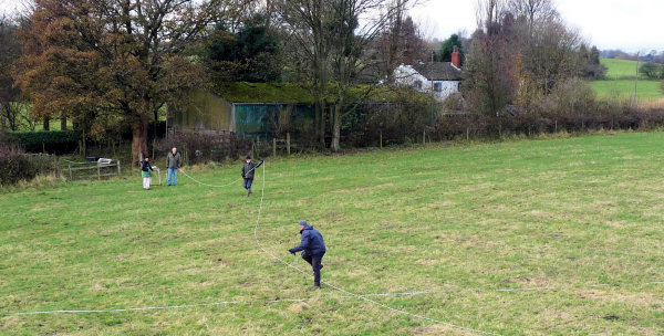
Last month saw our return to Standish Wood Fold to look at the field just south of Speckled Holly. It's on the projected line of Standish Wood Lane and, if the theory is correct that the Lane is the Roman road, then it must cross this field at some point. On the way there we met the farmer's son, (also called Tom Stafford) who was curious to know if we'd found anything (but he was happy, as we were, that there were no bulls to accompany us this time).
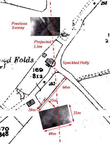 It was difficult for us to get a bearing in this field, however, as the projected line runs at about 45 degrees to the field boundary. Also the trees and cottage buildings prevented us from seeing the previous survey area. Using the top (north) corner of the field as our base, we picked our spot 60m eastward along the field boundary and set out a 25m x 40m survey area using 3, 4, 5, triangles. We were confident this area would cover the projected line and, with the meter filter on rural setting, we were able to complete the survey in a relatively short time. It was difficult for us to get a bearing in this field, however, as the projected line runs at about 45 degrees to the field boundary. Also the trees and cottage buildings prevented us from seeing the previous survey area. Using the top (north) corner of the field as our base, we picked our spot 60m eastward along the field boundary and set out a 25m x 40m survey area using 3, 4, 5, triangles. We were confident this area would cover the projected line and, with the meter filter on rural setting, we were able to complete the survey in a relatively short time.
As you can see, however, the results show absolutely nothing. The pattern produced is very typical of underlying geology, i.e. the lighter areas (higher resistivity) reflect the dryer soil on the higher ground. This suggests that the Roman road did not cross this field.
Another clue is that there are no signs on the ground of an agger, bank or terrace, which you might expect as the road came down the hill side. This field is on a ridge pointing towards Wigan, but the projected line come off this ridge pointing towards Scott Lane Bridge at Martland Mill, then on to Goose Green (eventually lining up, in theory, with the road leading south out of Wigan). Probing with a steel rod suggests a rocky sub-surface all over the field at no more than a ploughshare's depth. Curiously the ground is a-ceramic (i.e. not a single piece of pottery could be found). This suggests the field wasn't cultivated until recent times, which would give more chance for the road to survive if it was there. Our only conclusion is that the road did not cross this field and therefore the inference is that Standish Wood Lane is most likely not the Roman road leading north out of Wigan.
Tithe Map Workshops
Almost 500 Cheshire tithe maps and associated tithe appointments are now available online. Lancaster University Centre for North West Regional Studies are running workshops to explain how to use them. There will be two alternative sessions (in the morning and afternoon) on Saturday 4th December. They will be held at the Fylde College in Lancaster and will each last for about two and half hours.
Delegates will be tutored on how to download the maps from the internet and how to compare them with later Ordinance Survey maps (a certain level of computer expertise is required). If you are interested in attending, details will be available at our next meeting.
Next Meeting
Wednesday 1st December in the concert room of the Upper Morris Street Working Men's Club (off Greenough Street), starting at 7.30 pm as usual.
This month, by popular demand, Ian Miller, from Oxford Archaeology North will be joining us. However, as a departure from his usual update on Roman Wigan, Ian will be telling us about his excavations at the 17th
century Iron Slitting Mill at Lymm in Cheshire. Slitting mills were used for rolling and cutting wrought iron sheets into strips for making things like iron straps for wooden barrel. Ian's work at the Lymm mill was carried out in 2005 as a precursor to the site being consolidated into a beauty spot (here is their website). I'm sure he will be
presenting us with another fascinating talk.
Hope to see you at the meeting - BA
|