Chapters
|
Project: Greatacre Excavation Report
July 2005 |
| Background |
|
In the late 1960’s,
Alan Jennings was helping to dig a well on his father’s allotment in the Douglas
Valley. In those days, although less than 50 metres from the River Douglas, the only way
of getting clean water to that area was by creating your own supply. At about one and half metres down, however,
Allan’s dad hit something that made him immediately stop digging and jumped out the
trench. He told his son to start filling it in again and
warned him not to mention it to anyone. What
had spooked his dad all those years ago? Allan's dad, in fact, was convinced he had
hit a lead coffin that was probably part of a large cemetery.
Thirty-odd years later, with Roman remains being found in the town
centre and his dad long gone, Allan’s curiosity finally got the better of him. In May
this year he made a formal approach to the society with a view to investigating his
dad’s find. Things have changed quite a lot in the Douglas valley since those days.
The allotments have gone and a considerable amount of landscaping has taken place, but
Allan can still pinpoint the exact spot where his dad had excavated for the well.
Overgrown privet hedges once bordering his father’s plot and a small depression was
all Allan needed to convince him he was in the right place.
|
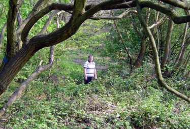
The Site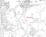
The site is on the east side of the River Douglas near
the end of the street called Greatacre (Grid Ref. SD 5875 0645). On an early map1 this area is referred to as the Bloody Mountains (strangely though, the Civil War skirmish
called The Battle of Wigan Lane, occurred on the other side of the valley). 100 metres to
the south is the road bridge over the river which carries the new inner ring road round
the back of Tesco's supermarket on to Wigan Lane. 100 metres upstream is a footbridge
where once stood the Sutton corn mill and where, up to the 19th century, the
small terraced-house community of Bottling
Wood once thrived. Apart from the odd spring, however, nothing appears to have happened on
the early maps in the area of investigation. (click here for larger image)
 Allan's contact with the society
started a trail of enquiry which led us to find out who the landowner is and whether we
could get permission to dig. As it happened this part of the Douglas Valley was subject to
a study for a flood defence initiative which included a barrier spanning the Douglas
valley just a few metres downstream from the find site. The land is in fact, owned by Wigan Council, who had already given a commission to
United Utilities to install overflow tanks and a new drainage system as part of the first
phase of the flood defences. It was therefore
imperative for us to discover the extent of this work and whether it would affect our find
site. Fortunately for us it turned out that the site lay just outside the work area and
therefore did not come under their remit. Permission
to dig was eventually secured by our chairman, Tom Glover, after negotiations with the
council who gave us a day to carry out our investigation. (click here for larger image) Allan's contact with the society
started a trail of enquiry which led us to find out who the landowner is and whether we
could get permission to dig. As it happened this part of the Douglas Valley was subject to
a study for a flood defence initiative which included a barrier spanning the Douglas
valley just a few metres downstream from the find site. The land is in fact, owned by Wigan Council, who had already given a commission to
United Utilities to install overflow tanks and a new drainage system as part of the first
phase of the flood defences. It was therefore
imperative for us to discover the extent of this work and whether it would affect our find
site. Fortunately for us it turned out that the site lay just outside the work area and
therefore did not come under their remit. Permission
to dig was eventually secured by our chairman, Tom Glover, after negotiations with the
council who gave us a day to carry out our investigation. (click here for larger image)
|
| Excavation |
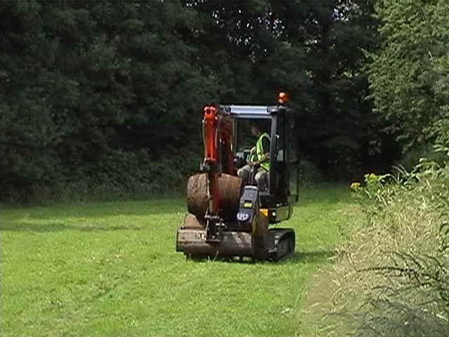
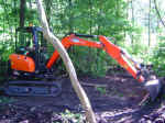  A small
excavator was hired for the day which was skillfully driven by Mark Hayward (his talents
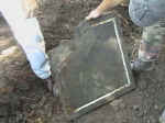
never fail to amaze). The first scraping of topsoil immediately uncovered a stone slab
about 60cm square and 5cm thick. It had been carefully worked with what appeared to be a
thin band of white marble inlay round the edge (strangely not accurate enough to be
decorative). A small
excavator was hired for the day which was skillfully driven by Mark Hayward (his talents
never fail to amaze). The first scraping of topsoil immediately uncovered a stone slab
about 60cm square and 5cm thick. It had been carefully worked with what appeared to be a
thin band of white marble inlay round the edge (strangely not accurate enough to be
decorative).
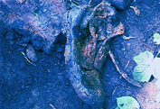
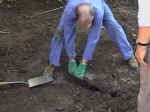
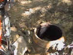
Underneath
the slab was a hole about 50cm in diameter and about a spade’s depth. The walling
appeared to be made of wood and there was also evidence of an iron rim. As Mark cleared
away the earth from around it, it became obvious that we had a wooden barrel complete with
iron hoops holding it together. Allan was totally perplexed by this, as he remembered
nothing of it on this spot (in fact when his dad had backfilled the hole, he had taken the
opportunity to bury allotment rubbish including a van engine which he had been
dismantling). The age of placement of this barrel could not have been long, however, as it was
sat on top of a steel oil drum that had its top and bottom cut out. It was obvious that
both the barrel and the drum had acted as liners for a well. We managed to get the barrel
and drum out but the hole was filled with black slutch2, too difficult to
remove, so, thinking we might be in the wrong spot, the hole was quickly backfilled.
 |
 |
 |
 |
| Click image for larger picture. |
Click image for larger picture. |
How could we miss a hole with an engine buried in it? Mark continued scraping away the ground
in the vicinity in the available area between the trees (the subsoil in this area is a
light brown clay which easily shows up signs of disturbance) but without success until we
eventually ran out of space. We decide to investigate the area around the edge of the
allotment where a large elderberry tree had grown. Allan said this was where they used to
dump their rubbish against the fence of the allotment. Sure enough brick and stone debris
began to emerge as soon as Mark put his bucket in (including one stone and one
terracotta water trough). Underneath this however there was good evidence of
disturbance in the form of a big blackish stain in the clay.
 |
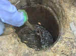 |
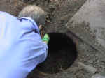
To our surprise, to the side of
this under more rubble, another hole appeared, again about 50cm in diameter and similarly
lined with wood. This time, however, the wood was much thinner (no more than 1cm thick), parallel sided and held together with wooden strapping.
We had found yet another well; this time it was filled with rubble, which we managed to
remove to depth of about a metre (including a fair amount of black slutch that filled the
bottom). The base of the well was just beyond our reach but Ken Stathem (our chief spade
man) could feel something hard and hollow with his spade just below the surface of the
slutch. My guess is that this maybe a culvert to aid water access and prevent the well from
silting up. Mark continued digging through the black stain next to the well, uncovering as
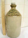
he went items of Victorian rubbish including a variety of footwear (boots and women’s
shoes) and a complete stone 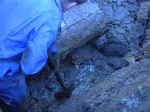 jug (made in
Leigh) with its stopper still intact. Before we could reach the bottom of the well we came
upon the water table (lower than expected) which prevented us going any further. The hole
was also at the limit of our capabilities without shoring. Even at this depth there were still quantities of Victorian pottery coming out from
under the water. It was therefore decided to backfill, having established that the
Victorians had been active even at this depth and that anything else would have probably
been destroyed. When we had finished, the site was returned to the state in which we found
it, minus the two wells which were made safe prior backfilling. jug (made in
Leigh) with its stopper still intact. Before we could reach the bottom of the well we came
upon the water table (lower than expected) which prevented us going any further. The hole
was also at the limit of our capabilities without shoring. Even at this depth there were still quantities of Victorian pottery coming out from
under the water. It was therefore decided to backfill, having established that the
Victorians had been active even at this depth and that anything else would have probably
been destroyed. When we had finished, the site was returned to the state in which we found
it, minus the two wells which were made safe prior backfilling.
|
 |
Click
on image for larger picture. |
Click
on image for larger picture. |
|
| Conclusion |
 |
Allan could not
understand what had happened to the hole his dad had dug and the engine and other rubbish
they had used to backfill it. We know that after Allan’s dad gave up using the
allotment he handed it over to his uncle. Our theory, therefore, is that his uncle went on
to build the well on that spot after investigating what his brother had found for himself.
We may never know what his father discovered and whether his uncle had later come across
it but the stone slab we discovered covering the first well is made of slate which is very
similar in colour to lead and could be mistaken for it.
(At least Allan did not
go away empty handed, as he now has an attractive antique wooden barrel in his front
garden.)
1 1894 25”
OS map sheet XCIII-8.
2
Slutch - a local term, wetter than mud but not quite sludge.
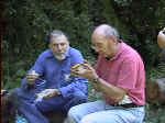
Participants
Tom
Glover ...Organiser
Bill
Aldridge ...Director
Mark
Hayward ...Digger Driver
Ken
Statham ....Chief Digger
Adrian
Morris ...Digger
Gail
Farrar and kids ...Moral support
Allan
Jennings ...Finder |
|