Following on from the Grand Arcade development and the proposed Southern Gateway redevelopment (including the Joint Services Centre), the council are now looking at the northern sector of the town centre. We have been asked to help by filling in a consultation document giving our opinion on how this area should be improved. The area is centred on New Market Street but stretches from Northway in the east to Frog Lane in the west as far as Hallgate. From our point of view this area is very important as it encompasses a large section of the supposed Roman ditch and agger identified by Sibson in the early 19th century. It also crosses the Roman road leading north out of Wigan and includes the grounds of old Wigan Hall (i.e. the Rectory). We will therefore be making sure the council are aware of our concerns and try to ensure that any potential for archaeology is not lost.
St William's School
Work has continued on this site following last month's very successful involvement with the schools in the area (see last month's newsletter). This month we have continued our search for the road with series of test pits (7 in all) along the line of the old school wall all the way up to the present reception block. Unfortunately all the pits produced a negative result. From ground level to the solid geology, the layers comprised of topsoil, red ash with light sand, red bricks and demolition rubbish with dark soil and dark ash. The poor result here and at Leaway is forcing us to consider that the line has either been obliterated here or that it didn't take this route at all. Therefore sites further north are now being looked at, particularly along the line of a series of tracks and hedgerows shown on the 1849 6" OS map. These include George Street just north of St William's school, the playing field of Ince CE Primary School and Anderton Street on the other side of Ince Green Lane.
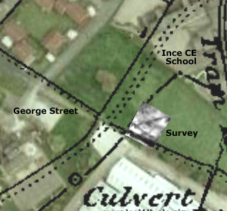
Ince CE Primary School
Just before the end of term last year we carried out a resistivity survey of this school's playing field where we suspected the line of the road could have ran. Again the exercise involved the school-children who showed great enthusiasm and interest in our activities. The result showed that the original ground level in this area is not as deep as in other areas we have looked at. It also produced a large ditch feature which seems to be aligned with the field boundary and track marked on the 1849 6" OS map. The width of the feature (3m) suggests a hollow way which would be a significant find in itself (usually medieval though).
Anderton Street
Last month an opportunity arose to investigate a vacant plot next to Ince Labour Club opposite Anderton Street mill. A series of 5 test pits were dug but once again the results were not positive - plenty of cobbles, clay and sand layers, but nothing conclusive.
Wigapedia
Dave Horrocks, our web designer, has created this new facility which will act as a repository for information about Wigan's history and archaeology. It will only be available to members but they will be able to make their own contributions (similarly to the original Wikipedia), to hopefully build a useful resource for researching Wigan's heritage. We have also introduced an on-line membership scheme for those unable attend meetings, at the reduced cost of £5. Please contact me through the website for further details.
Next Meeting
Wednesday 5th February at the District Scout HQ (Baden Powell Centre) in Greenough Street, starting at 7.30 pm as usual. This month we have Steve Hewlit who used teach GCSE Archaeology at the Wigan College. His main interest however is in Geology and particularly that of the Wigan area. I have asked him if he could possibly combine the two for us. His talk is therefore entitled the Geology of Archaeology in the Wigan area.
Hope to see you there B.A.
|